METAR & TAF KGBR
KGBR does not publish a METAR.
Showing the nearest reporting station: KPSF (PITTSFIELD MUNI) · 15.4 NM away. Conditions at KGBR may differ.
METAR · KPSF
Observed 11:54Z
KPSF 271154Z AUTO 00000KT 10SM SCT060 17/14 A2986 RMK AO2 SLP088 T01720144 10172 20128 51004
- Wind
- 000° @ 0 kt
- Visibility
- 10 SM
- Temp / Dew
- 17°C / 14°C
- Altimeter
- 29.86 inHg
- Clouds
- SCT
- Density alt
- 1,231 ft
- Ceiling
- Unlimited
- Rules
- VFR
Airport info & contacts
Manager on record, flight service, ARTCC, attendance schedule and pattern altitude — published by the FAA and refreshed every 28 days.
Location
- From city
- 2 NM W
- VFR sectional
- NEW YORK
- ARTCC
- ZBW · BOSTON
- NOTAM facility
- BTV (NOTAM-D)
Airport manager
- Name
- JOSEPH SOLAN
- Phone
- 413-528-1010
- Address
- 70 EGREMONT PLAIN RD., 70 EGREMONT PLAIN RD., GREAT BARRINGTON MA 01230
Flight service · Hours
- FSS BTV
- BURLINGTON1-800-WX-BRIEF
- Attendance
- 0800-1700
Frequencies
Tap any row to copy the frequency to your clipboard.
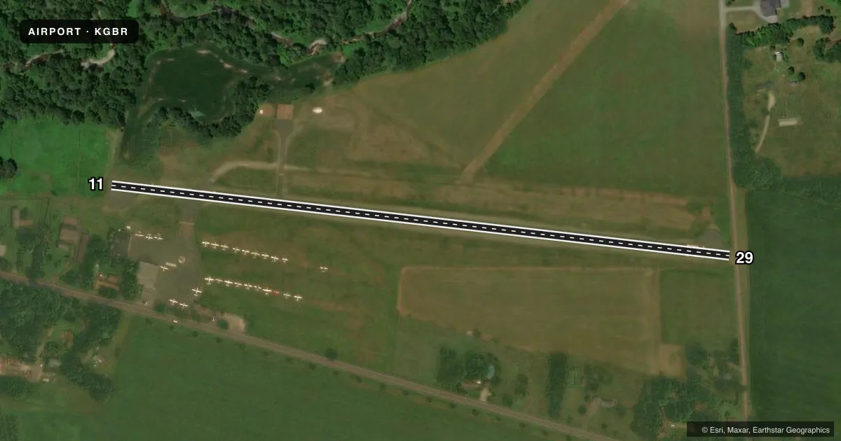
Runways & pattern
Full pagePattern entry · RWY 11
LEFT TRAFFICRunway end performance
| End | TORA | TODA | ASDA | LDA | VGSI | Approach lights | Obstruction |
|---|---|---|---|---|---|---|---|
| 11 | — | — | — | — | — | — | 30', trees, 425' from thr, 130' R of cntrln, slope 7 |
| 29 | — | — | — | — | — | — | 57', trees, 1000' from thr, 210' R of cntrln, slope 14 |
Declared distances in feet. TORA = takeoff run available, TODA = takeoff distance, ASDA = accelerate-stop, LDA = landing distance.
Airport sketch
Runways drawn to scale from FAA survey coordinates, rendered over satellite imagery. Not for navigation.
Approaches & charts
Services on the field
Fuel grades, oxygen, maintenance, ramp storage and lighting — as declared to the FAA by the airport operator.
Fuel & services
- Fuel
- 100LL
- Oxygen (bottled)
- High pressure
- Oxygen (bulk)
- Not available
- Airframe repair
- Major
- Power plant repair
- Major
- Other services
- CHTR,INSTR,RNTL
Ramp & ground
- Transient storage
- Tie-down
- Hangar
- Landing fee
- Yes
- Customs
- Not available
- Lighting schedule
- SEE RMK
- Beacon schedule
- SS-SR
- Beacon
- White / Green (civil land)(WG)
- Wind indicator
- Lighted
- Segmented circle
- No
Fuel & FBOs
Cheapest 100LL and Jet A on the field and nearby. Always confirm with the FBO before taxi.
Airport notes
Surface conditions, obstructions, local procedures, lighting outages and other notes published with each FAA cycle.
General notes
- TGLS NA.
- PRACTICE VFR GPS RWY 11 NA WHEN RWY 29 IS IN USE FOR STUDENT TFC.
- FOR CD CTC ALBANY APCH AT 518-862-2299.
- WILDLIFE ON & INVOF ARPT.
- COLD TEMPERATURE AIRPORT. ALTITUDE CORRECTION REQUIRED AT OR BELOW -19C.
- COMPASS ROSE ADZY ONLY, NOT CRTFYD.
Lighting notes
- ACTVT REIL RWY 11; LIRL RWY 11/29 - 121.6.
Approach & departure obstructions
- 29+15 FT ROAD IN PRIM SFC AREA.
- 11LGTD THR RELCTD 170 FT; 2409 FT OF RWY USBL FOR NGT OPS.
- 29APCH RATIO 19:1 TO DTHR.
Other notes
- THIS AIRPORT HAS BEEN SURVEYED BY THE NATIONAL GEODETIC SURVEY.
- FILED FOR RECORD PURPOSES ONLY.
- AVCARD NOT ACPTD.
VFR map & nearby airports
VFR sectional. Tap any ICAO chip to open that airport.
Key facts · KGBR
Answer card- ICAO
- KGBR
- Name
- GREAT BARRINGTON
- Location
- GREAT BARRINGTON, MASSACHUSETTS
- Elevation
- 739.4 ft MSL
- Traffic pattern altitude
- 1,739.4 ft MSL (1,000 AGL)
- Control tower
- Non-towered (use CTAF)
- Total runways
- 1
- Longest runway
- 11/29 · 2,579 ft
- Published ILS approaches
- 0
- Published frequencies
- 4
- Magnetic variation
- 14°
- Current flight rules
- VFR
- Current wind
- 000° at 0 kt
- Favored runway now
- –
Great Barrington Airport (KGBR) sits in Great Barrington, Massachusetts. Field elevation is 739.4 ft MSL. The airport has one runway. Runway 11/29 is 2,579 ft asphalt, so plan for a short-field mindset. There is no control tower. Use CTAF 122.8 for local traffic. The published pattern altitude is not listed, so use the standard 1,000 ft AGL pattern unless the current Chart Supplement says otherwise.
No ILS approaches are published here. Albany Approach handles clearance delivery and approach or departure services on 132.825 and 307.2. Berkshire Aviation is on the field. It carries AVGAS 100LL. Touch-and-go landings are not authorized. Runway 11 has REILs. Low intensity runway lights are installed on 11/29 and operate on 121.6. The lighted threshold on runway 11 is relocated 170 ft, so only 2,409 ft is usable for night operations. Runway 29 has a displaced threshold and a 15 ft road in the primary surface area near that end.
This is a cold temperature airport. Altitude correction is required at or below minus 19 degrees Celsius. Practice VFR GPS approaches to runway 11 are not authorized when runway 29 is in use for student traffic. Check the current Chart Supplement and call the airport operator or Berkshire Aviation before you go if you need current operational details.