METAR & TAF 20N
20N does not publish a METAR.
Showing the nearest reporting station: KPOU (HUDSON VALLEY RGNL) · 21.8 NM away. Conditions at 20N may differ.
METAR · KPOU
Observed 12:53Z
KPOU 271253Z AUTO 00000KT 10SM CLR 23/18 A2983 RMK AO2 SLP097 T02280178
- Wind
- 000° @ 0 kt
- Visibility
- 10 SM
- Temp / Dew
- 23°C / 18°C
- Altimeter
- 29.83 inHg
- Clouds
- CLR
- Density alt
- 1,254 ft
- Ceiling
- Unlimited
- Rules
- VFR
Airport info & contacts
Manager on record, flight service, ARTCC, attendance schedule and pattern altitude — published by the FAA and refreshed every 28 days.
Location
- From city
- 4 NM N
- VFR sectional
- NEW YORK
- ARTCC
- ZNY · NEW YORK
- NOTAM facility
- ISP (NOTAM-D)
Airport manager
- Name
- TODD COGGESHALL
- Phone
- 845-481-1559
- Address
- 1161 FLATBUSH AVE, KINGSTON NY 12401
Flight service · Hours
- FSS ISP
- NEW YORK1-800-WX-BRIEF
- Attendance
- JAN-DEC · 0900-1700
Frequencies
Tap any row to copy the frequency to your clipboard.
Runways & pattern
Full pagePattern entry · RWY 15
LEFT TRAFFICRunway end performance
| End | TORA | TODA | ASDA | LDA | VGSI | Approach lights | Obstruction |
|---|---|---|---|---|---|---|---|
| 15 | 3,100' | 3,100' | 3,010' | 2,775' | PAPI 2-box left(4.5°) | — | 75', tree, 214' from thr, 183' R of cntrln, slope 0 |
| 33 | 3,100' | 3,100' | 2,939' | 2,630' | PAPI 2-box left(3.6°) | — | 33', pole, 257' from thr, 178' R of cntrln, slope 1 |
Declared distances in feet. TORA = takeoff run available, TODA = takeoff distance, ASDA = accelerate-stop, LDA = landing distance.
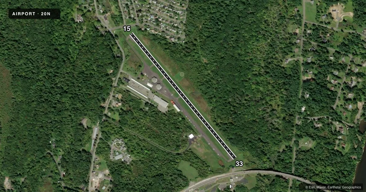
Airport sketch
Runways drawn to scale from FAA survey coordinates, rendered over satellite imagery. Not for navigation.
Approaches & charts
Services on the field
Fuel grades, oxygen, maintenance, ramp storage and lighting — as declared to the FAA by the airport operator.
Fuel & services
- Fuel
- 100LLA
- Oxygen (bottled)
- Not available
- Oxygen (bulk)
- Not available
- Airframe repair
- Major
- Power plant repair
- Major
- Other services
- INSTR,RNTL
Ramp & ground
- Transient storage
- Tie-down
- Landing fee
- Yes
- Customs
- Not available
- Lighting schedule
- SEE RMK
- Wind indicator
- Lighted
- Segmented circle
- Yes
Fuel & FBOs
Cheapest 100LL and Jet A on the field and nearby. Always confirm with the FBO before taxi.
Airport notes
Surface conditions, obstructions, local procedures, lighting outages and other notes published with each FAA cycle.
General notes
- PAEW ADJACENT TWY/RWY.
- VOLUNTARY NOISE ABTMT PROC IN EFCT. AVOID OVERFLIGHT OF HOUSING DEVELOPMENT ADJ TO N END OF RWY.
- NO RUNUPS AT RY 15 THLD.
- NO LINE OF SIGHT BTN RY 33 HOLD LINE & ACFT IN FINAL .25 MI OF APCH TO RY 33.
- RENTAL CAR AVBL - 845-338-6929.
- FOR CD CTC NEW YORK APCH AT 516-683-2448
Lighting notes
- ACTVT PAPI RYS 15 & 33 - 123.3. MIRL RY 15/33; REIL RY 33 & TWY LGTS OPERATE 123.3 DUSK-DAWN.
Approach & departure obstructions
- 15RWY 15: 25 FT LIGHT POLE, 136 FT FM RWY 116 FT LEFT. 12 FENCE, 125 FT FM RWY LEFT & RIGHT. 61 FT TREE 126 FT FM RWY 181 FT LEFT. 15 FT ROAD, 135 FT FM RWY LEFT & RIGHT.
- 33RWY 33: 7 FT FENCE, 164 FT FM RWY; 8 FT SHED, 152 FT FM RWY 126 FT LEFT.
- 15RY 15 PAPI UNUSABLE 5 DEGS LEFT OF COURSE & 8 DEGS RIGHT OF COURSE.
- 15CTLNG OBSTN EXCEEDS A 45 DEG SLP.
- 33RY 33 HAS +73 FT TREES, 742 FT FM RY, 85 FT LT, CLNC SLOPE 14:1 BASED ON DSPLCD THLD.
Other notes
- EXISTED PRIOR TO 1959.
- AUTOMATED UNICOM.
- 2UNATNDD THANKSGIVING AND CHRISTMAS.
VFR map & nearby airports
VFR sectional. Tap any ICAO chip to open that airport.
Key facts · 20N
Answer card- ICAO
- 20N
- Name
- KINGSTON-ULSTER
- Location
- KINGSTON, NEW YORK
- Elevation
- 147.4 ft MSL
- Traffic pattern altitude
- 1,147.4 ft MSL (1,000 AGL)
- Control tower
- Non-towered (use CTAF)
- Total runways
- 1
- Longest runway
- 15/33 · 3,100 ft
- Published ILS approaches
- 0
- Published frequencies
- 4
- Magnetic variation
- 13°
- Current flight rules
- VFR
- Current wind
- 000° at 0 kt
- Favored runway now
- –
Kingston-Ulster Airport sits in Kingston, New York. Field elevation is 147.4 ft MSL. The airport has one runway. Runway 15/33 is 3,100 ft long and asphalt. There is no control tower. The published pattern altitude is not listed, so use the standard 1,000 ft AGL for light piston traffic unless the current FAA Chart Supplement says otherwise.
No ILS approaches are published here. Richmor Aviation is on the field. It carries 100LL and Jet A. The airport uses CTAF 122.8 and UNICOM 122.8. Approach and departure service is on 132.75 and 363.1 with New York. PAPI is available on runways 15 and 33 on 123.3. Medium intensity runway lights are installed on 15/33. Runway end identifier lights are on runway 33. Taxiway lights also operate on 123.3 from dusk to dawn.
A first-time pilot should pay close attention to the published obstructions. Runway 15 has multiple close-in objects near the approach path. Runway 33 also has nearby fences, a shed and trees. There is a voluntary noise abatement procedure. Avoid overflight of the housing development near the north end of the runway. There is also no line of sight between the runway 33 hold line and aircraft on short final inside the last quarter mile. Use extra caution when taxiing and clearing for departure.