METAR & TAF KPOU
Current METAR
Observed 11:53Z
KPOU 271153Z AUTO 00000KT 10SM CLR 20/17 A2983 RMK AO2 SLP096 T02000172 10200 20167 53008
- Wind
- 000° @ 0 kt
- Visibility
- 10 SM
- Temp / Dew
- 20°C / 17°C
- Altimeter
- 29.83 inHg
- Clouds
- CLR
- Density alt
- 914 ft
- Ceiling
- Unlimited
- Rules
- VFR
Airport info & contacts
Manager on record, flight service, ARTCC, attendance schedule and pattern altitude — published by the FAA and refreshed every 28 days.
Location
- From city
- 4 NM S
- VFR sectional
- NEW YORK
- ARTCC
- ZNY · NEW YORK
- NOTAM facility
- POU (NOTAM-D)
Airport manager
- Name
- JEFF DURAND
- Phone
- 845-463-6000
- Address
- 263 NEW HACKENSACK RD, WAPPINGERS FALLS NY 12590
Flight service · Hours
- FSS ISP
- NEW YORK1-800-WX-BRIEF
- Attendance
- 0700-2130
Frequencies
Tap any row to copy the frequency to your clipboard.
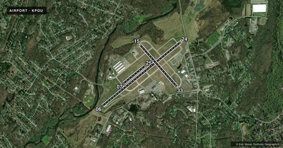
Runways & pattern
Full pagePattern entry · RWY 06
LEFT TRAFFIC| Runway | Heading (°M) | Length | Surface | Traffic |
|---|---|---|---|---|
| 06/24 | 39° / 219° | 5,001 ft | ASPH | Standard L |
| 15/33 | 127° / 307° | 2,743 ft | ASPH-CONC | Standard L |
| 07/25 | 39° / 219° | 1,357 ft | TURF | Standard L |
Runway end performance
| End | TORA | TODA | ASDA | LDA | VGSI | Approach lights | Obstruction |
|---|---|---|---|---|---|---|---|
| 06 | 5,001' | 5,001' | 5,001' | 5,001' | PAPI 4-box left(3°) | MALSR | 18', tree, 380' from thr, 300' R of cntrln, slope 10 |
| 24 | 5,001' | 5,001' | 5,001' | 4,886' | PAPI 4-box left(3.42°) | — | 71', tree, 210' from thr, 400' R of cntrln, slope 0 |
| 15 | 2,743' | 2,743' | 2,743' | 2,743' | — | — | 51', trees, 900' from thr, 100' R of cntrln, slope 13 |
| 33 | 2,743' | 2,743' | 2,743' | 2,743' | VASI 4-box left(3.75°) | — | 37', trees, 240' from thr, 200' R of cntrln, slope 1 |
| 25 | — | — | — | — | — | — | 24', ant, 215' from thr, 90' R of cntrln, slope 8 |
Declared distances in feet. TORA = takeoff run available, TODA = takeoff distance, ASDA = accelerate-stop, LDA = landing distance.
Airport sketch
Runways drawn to scale from FAA survey coordinates, rendered over satellite imagery. Not for navigation.
Approaches & charts
ILS · 1
Services on the field
Fuel grades, oxygen, maintenance, ramp storage and lighting — as declared to the FAA by the airport operator.
Fuel & services
- Fuel
- 100LLA
- Airframe repair
- Major
- Power plant repair
- Major
- Other services
- CARGO,CHTR,INSTR,RNTL,SALES
Ramp & ground
- Transient storage
- Tie-down
- Hangar
- Landing fee
- Yes
- Customs
- Not available
- Lighting schedule
- SEE RMK
- Beacon schedule
- SS-SR
- Beacon
- White / Green (civil land)(WG)
- Wind indicator
- Lighted
- Segmented circle
- No
Fuel & FBOs
Cheapest 100LL and Jet A on the field and nearby. Always confirm with the FBO before taxi.
Airport notes
Surface conditions, obstructions, local procedures, lighting outages and other notes published with each FAA cycle.
General notes
- NOISE ABATEMENT PROCEDURES IN EFCT CTC AMGR FOR DETAILS.
- BIRDS & DEER ON & INVOF ARPT.
- RWY 07/25 RESTRICTED TO ACFT LESS THAN 12500 LBS.
- CTC FBO DURG BUS HRS AT 845-849-3770 FOR AFT HRS FUEL SVC.
- TWY C, TWY G T-HNGR TXL, & TWY J T-HNGR TXL CLSD TO ACR ACFT.
- FOR CD WHEN ATCT CLSD CTC NEW YORK APCH AT 516-683-2448 OR 121.8.
- RWY 06 TGL AND PRACTICE APCHS PROHIBITED DUE TO OBSCD LINE OF SIGHT FM ATCT.
- RWY 15/33 CLSD TO SKED ACR OPS WITH MORE THAN 9 PAX SEATS AND NON SKED ACR OPS WITH MORE THAN 30 PAX SEATS EXCP FOR TAXI.
- NEW NOISE ABATEMENT: REPETITIVE OPNS PROHIBITED WHEN ATCT CLSD.
Lighting notes
- WHEN ATCT CLSD ACTVT MALSR RWY 06; REIL RWY 24; HIRL RWY 06/24 - CTAF.
Runway surface & condition
- 06/24PCR VALUE: 396/F/C/X/T
- 07/25CLSD NGTS, DURG IMC, & FM NOV 1 - APR 15.
- 15/33RWY 15/33 NOT AVBL FOR PART 121/PART 380 OPS WITH SKED PAX CARRYING OPS MORE THAN 9 PAX SEATS AND NON-SKED PAX CARRYING OPS MORE THAN 30 PAX SEATS. NO PART 121/PART 380 OPS EXC FOR TAX.
Approach & departure obstructions
- 33+13 FT OBSTRUCTION LGTD POLE 160 FT FM THLD 150 FT LEFT.
- 33VASI RSTD TO CAT A ACFT ONLY.
- 24APCH SLP 4:1 TO DTHR.
Other notes
- PPR 24 HRS FOR ACR OPS WITH MORE THAN 30 PAX SEATS; CALL AMGR 845-463-6000. INDEX B COVERAGE IS PRVDD.
- LANDING FEE FOR MULTI-ENGINE AIRCRAFT.
- TPA SMALL ACFT 1034 FT, LARGE ACFT 1834 FT.
VFR map & nearby airports
VFR sectional. Tap any ICAO chip to open that airport.
Key facts · KPOU
Answer card- ICAO
- KPOU
- Name
- HUDSON VALLEY RGNL
- Location
- POUGHKEEPSIE, NEW YORK
- Elevation
- 163.5 ft MSL
- Traffic pattern altitude
- 1,163.5 ft MSL (1,000 AGL)
- Control tower
- Towered · 0700-2200 (15 MAY-14 SEP); 0700-2100 (15 SEP- 14 MAY)
- Total runways
- 3
- Longest runway
- 06/24 · 5,001 ft
- Published ILS approaches
- 1
- Published frequencies
- 9
- Magnetic variation
- 12°
- Current flight rules
- VFR
- Current wind
- 000° at 0 kt
- Favored runway now
- –
Hudson Valley Rgnl sits in Poughkeepsie, New York. Field elevation is 163.5 ft MSL. The airport has three runways. The longest is 06/24 at 5,001 ft. It also has 15/33 at 2,743 ft and a turf runway, 07/25, at 1,357 ft. The tower is open daily. Hours are 0700-2200 from 15 May through 14 Sep. Hours are 0700-2100 from 15 Sep through 14 May. One ILS is published for runway 06. Pattern altitude is published as 1,034 ft MSL for small aircraft. Large aircraft use 1,834 ft MSL.
FlightLevel Aviation is on the field. It carries 100LL, Jet A and Jet A Prist. The airport has published noise abatement procedures. Repetitive operations are prohibited when the tower is closed. Runway 06 has a tower sightline issue, so touch-and-go landings and practice approaches are prohibited there. Birds and deer are also noted in the airport area, so keep a sharp scan on departure and in the pattern.
Runway 07/25 is closed at night, in IMC and from November 1 through April 15. It is also restricted to aircraft under 12,500 lb. When the tower is closed, clearance delivery goes through New York Approach. For current noise details or any special operating limits, check the current FAA Chart Supplement or call the airport operator before you go.