METAR & TAF KMGJ
Current METAR
Observed 11:54Z
KMGJ 271154Z AUTO 19004KT 10SM CLR 20/17 A2984 RMK AO2 SLP101 60000 T02000172 10200 20167 53007
- Wind
- 190° @ 4 kt
- Visibility
- 10 SM
- Temp / Dew
- 20°C / 17°C
- Altimeter
- 29.84 inHg
- Clouds
- CLR
- Density alt
- 1,158 ft
- Ceiling
- Unlimited
- Rules
- VFR
Airport info & contacts
Manager on record, flight service, ARTCC, attendance schedule and pattern altitude — published by the FAA and refreshed every 28 days.
Location
- From city
- 1 NM SW
- VFR sectional
- NEW YORK
- ARTCC
- ZNY · NEW YORK
- NOTAM facility
- MGJ (NOTAM-D)
Airport manager
- Name
- EDWARD MAGRYTA
- Phone
- 845-457-4925
- Address
- 500 DUNN RD., MONTGOMERY NY 12549-2402
Flight service · Hours
- FSS ISP
- NEW YORK1-800-WX-BRIEF
- Attendance
- SUN · 0830-1630
- NOV--APR · MON-SAT · 0700-1700
- MAY-OCT · MON-SAT · 0700-1900
Frequencies
Tap any row to copy the frequency to your clipboard.
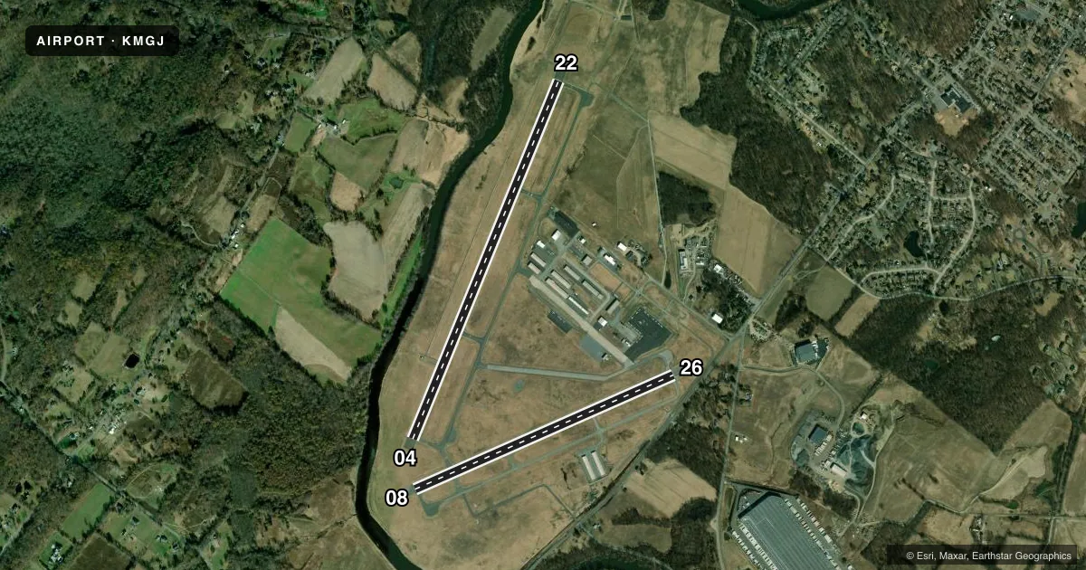
Runways & pattern
Full pagePattern entry · RWY 22
RIGHT TRAFFIC| Runway | Heading (°M) | Length | Surface | Traffic |
|---|---|---|---|---|
| 04/22Favored | 8° / 188° | 5,006 ft | ASPH | 22 R |
| 08/26 | 52° / 232° | 3,664 ft | ASPH | 26 R |
Runway end performance
| End | TORA | TODA | ASDA | LDA | VGSI | Approach lights | Obstruction |
|---|---|---|---|---|---|---|---|
| 04 | — | — | — | — | PAPI 4-box left(3°) | — | 54', trees, 555' from thr, 489' R of cntrln, slope 6 |
| 22 | — | — | — | — | PAPI 2-box left(3°) | — | 65', trees, 1272' from thr, 523' R of cntrln, slope 16 |
| 08 | — | — | — | — | PAPI 2-box left(3.5°) | — | 49', trees, 790' from thr, 180' R of cntrln, slope 12 |
| 26 | — | — | — | — | PAPI 2-box left(3.5°) | — | 87', fence, 526' from thr, 138' R of cntrln, slope 3 |
Declared distances in feet. TORA = takeoff run available, TODA = takeoff distance, ASDA = accelerate-stop, LDA = landing distance.
Airport sketch
Runways drawn to scale from FAA survey coordinates, rendered over satellite imagery. Not for navigation.
Approaches & charts
ILS · 1
Services on the field
Fuel grades, oxygen, maintenance, ramp storage and lighting — as declared to the FAA by the airport operator.
Fuel & services
- Fuel
- 100LLA
- Oxygen (bottled)
- HIGH/LOW
- Oxygen (bulk)
- HIGH/LOW
- Airframe repair
- Major
- Power plant repair
- Major
- Other services
- CHTR,INSTR
Ramp & ground
- Transient storage
- Hangar
- Landing fee
- No fee published
- Customs
- Not available
- Lighting schedule
- SEE RMK
- Beacon schedule
- SS-SR
- Beacon
- White / Green (civil land)(WG)
- Wind indicator
- Lighted
- Segmented circle
- Yes
Fuel & FBOs
Cheapest 100LL and Jet A on the field and nearby. Always confirm with the FBO before taxi.
Airport notes
Surface conditions, obstructions, local procedures, lighting outages and other notes published with each FAA cycle.
General notes
- 9 FT STABILIZED SHOULDER EACH SIDE OF RWY 8/26.
- NOISE ABATEMENT PROCEDURES IN EFCT; CTC AMGR 845-457-4925.
- BE AWARE OF LRG TBJT ACFT INVOF STEWART ARPT LCTD 7 NM ESE. 800 FT HILL 1/2 MILE NW OF ARPT ON DOWNWIND/BASE LEG FOR RWY 22.
- SAWRS
- FUEL AVAIL. AFT HRS BY CREDIT CARD SELF-SVC RAMP.
- DEER AND BIRDS ON AND INVOF ARPT.
- RWY 04 DESGND CALM WIND RWY.
- FOR CD CTC NEW YORK APCH AT 516-683-2448 OR 123.85
- RWY 04-22 HIRLS ON PHOTOCELL DRG DAY, ON REMOTE AT NGT.
Lighting notes
- ACTVT HIRL RWY 04/22; MIRL RWY 08/26; TWY LGTS - CTAF. REIL RWY 04 & 22; PAPI RWYS 04 & 22; 08 & 26 OPR CONSLY. PCL ONLY AVBL SS-SR.
Approach & departure obstructions
- 26RWY 26 APCH SLOPE 11:1 DUE TO 56 FT TREE 644 FT FM DTHR.
Other notes
- ESTBD PRIOR TO 1959.
- SEGMENTED CRC WITH WIND CONE LCTD MID FLD IN AREA BTN RWYS.
- TPA: 1030 FT AGL SINGL ENG, 1330 FT AGL MULT ENG/TURBOPROP/JET.
- AUTOMATED UNICOM.
- WIND IND ON RWYS 04, 22, 26.
VFR map & nearby airports
VFR sectional. Tap any ICAO chip to open that airport.
Key facts · KMGJ
Answer card- ICAO
- KMGJ
- Name
- ORANGE COUNTY
- Location
- MONTGOMERY, NEW YORK
- Elevation
- 369.9 ft MSL
- Traffic pattern altitude
- 1,369.9 ft MSL (1,000 AGL)
- Control tower
- Non-towered (use CTAF)
- Total runways
- 2
- Longest runway
- 04/22 · 5,006 ft
- Published ILS approaches
- 1
- Published frequencies
- 5
- Magnetic variation
- 14°
- Current flight rules
- VFR
- Current wind
- 190° at 4 kt
- Favored runway now
- RWY 22
Orange County Airport is in Montgomery, New York. The field elevation is 369.9 ft MSL. It has two asphalt runways. The longest is runway 04/22 at 5,006 ft. This is an uncontrolled field. CTAF and UNICOM are both 122.725. The airport has one ILS approach to runway 04. The published pattern altitude is 1,030 ft AGL for single-engine aircraft. Multi-engine, turboprop and jet traffic use 1,330 ft AGL.
Orange County Airport is a practical stop for piston and turbine traffic in the Hudson Valley. The on-field FBO is Orange County Airport. It carries 100LL and Jet A with Prist. After-hours fuel is available by credit card self-service on the ramp. The airport uses pilot controlled lighting from sunset to sunrise. Runway 04/22 has high intensity lights. Runway 08/26 has medium intensity lights. Runway 26 has a steep approach path because of a 56-foot tree near the displaced threshold. There is also an 800-foot hill half a mile northwest of the airport on the downwind and base leg for runway 22. Noise abatement procedures are in effect. Check with the airport manager before arrival if you need the current guidance. Watch for deer, birds and traffic from Stewart Airport nearby.