METAR & TAF N82
N82 does not publish a METAR.
Showing the nearest reporting station: KMGJ (ORANGE COUNTY) · 10.2 NM away. Conditions at N82 may differ.
METAR · KMGJ
Observed 12:54Z
KMGJ 271254Z AUTO 00000KT 10SM CLR 22/18 A2984 RMK AO2 SLP101 T02170178
- Wind
- 000° @ 0 kt
- Visibility
- 10 SM
- Temp / Dew
- 22°C / 18°C
- Altimeter
- 29.84 inHg
- Clouds
- CLR
- Density alt
- 1,619 ft
- Ceiling
- Unlimited
- Rules
- VFR
Airport info & contacts
Manager on record, flight service, ARTCC, attendance schedule and pattern altitude — published by the FAA and refreshed every 28 days.
Location
- From city
- 2 NM NE
- VFR sectional
- NEW YORK
- ARTCC
- ZNY · NEW YORK
- NOTAM facility
- ISP (NOTAM-D)
Airport manager
- Name
- DANIEL YATES
- Phone
- (845) 888-2791
- Address
- WURTSBORO AIRPARK, LLC, 50 BARONE RD, WURTSBORO NY 12790
Flight service · Hours
- FSS ISP
- NEW YORK1-800-WX-BRIEF
- Attendance
- 0900-1700
Frequencies
Tap any row to copy the frequency to your clipboard.
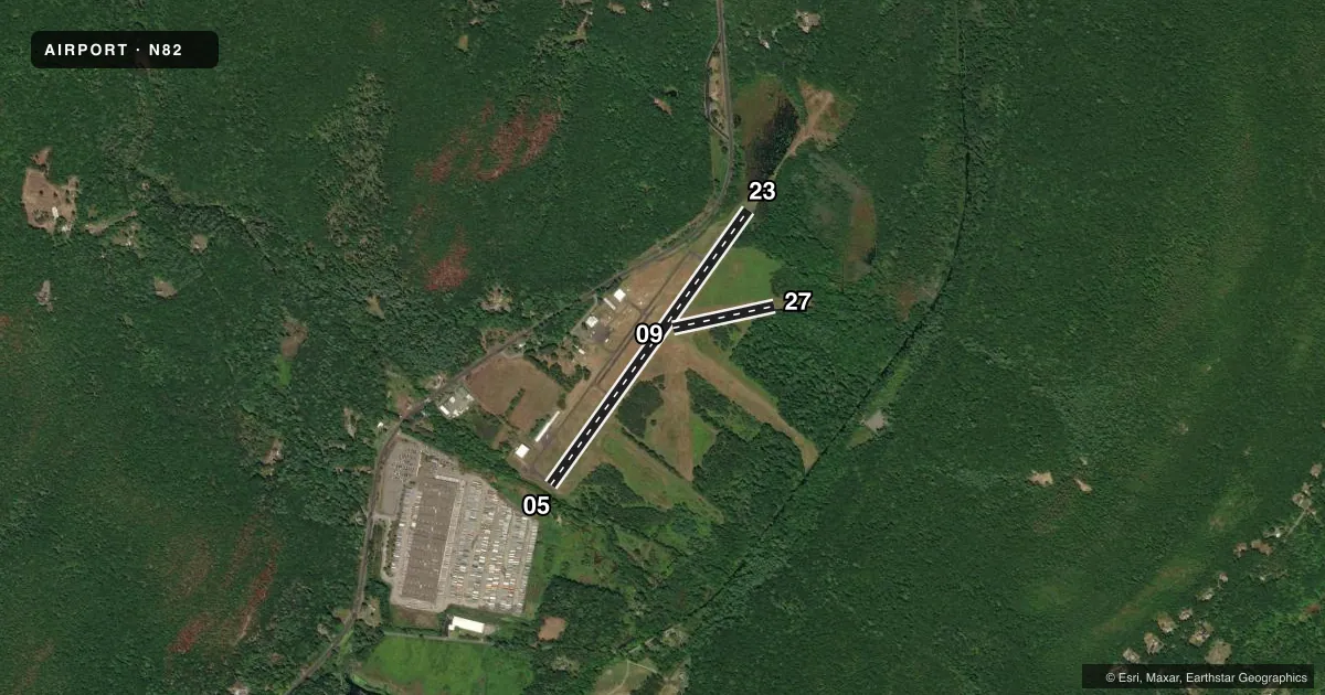
Runways & pattern
Full pagePattern entry · RWY 05
LEFT TRAFFIC| Runway | Heading (°M) | Length | Surface | Traffic |
|---|---|---|---|---|
| 05/23 | 24° / 204° | 3,591 ft | ASPH | Standard L |
| 09/27 | 66° / 246° | 1,101 ft | TURF | Standard L |
Runway end performance
| End | TORA | TODA | ASDA | LDA | VGSI | Approach lights | Obstruction |
|---|---|---|---|---|---|---|---|
| 05 | — | — | — | — | — | — | 28', trees, 372' from thr, 66' R of cntrln, slope 6 |
| 23 | — | — | — | — | — | — | 17', trees, 363' from thr, 94' R of cntrln, slope 9 |
| 09 | — | — | — | — | — | — | 103', trees, 977' from thr, 68' R of cntrln, slope 9 |
| 27 | — | — | — | — | — | — | 79', trees, 95' from thr, 113' R of cntrln, slope 1 |
Declared distances in feet. TORA = takeoff run available, TODA = takeoff distance, ASDA = accelerate-stop, LDA = landing distance.
Airport sketch
Runways drawn to scale from FAA survey coordinates, rendered over satellite imagery. Not for navigation.
Approaches & charts
Services on the field
Fuel grades, oxygen, maintenance, ramp storage and lighting — as declared to the FAA by the airport operator.
Fuel & services
- Fuel
- 100LL
- Oxygen (bottled)
- Not available
- Oxygen (bulk)
- Not available
- Airframe repair
- Not available
- Power plant repair
- Not available
- Other services
- GLD,INSTR,RNTL,SALES,TOW
Ramp & ground
- Transient storage
- Tie-down
- Hangar
- Landing fee
- No fee published
- Customs
- Not available
- Wind indicator
- Yes
- Segmented circle
- No
Fuel & FBOs
Cheapest 100LL and Jet A on the field and nearby. Always confirm with the FBO before taxi.
Airport notes
Surface conditions, obstructions, local procedures, lighting outages and other notes published with each FAA cycle.
General notes
- DEER ON & INVOF ARPT.
- EXTSV GLIDER ACTIVITY.
- FOR CD CTC NEW YORK APCH AT 516-683-2448
Approach & departure obstructions
- 05RWY 05 HAS +8 FT BERM 50 FT FM THLD; +88 FT TREE, 139 FT FM THLD; 165 FT RIGHT.
- 23RWY 23: 40 FT TREES; 37 FT FM THLD, 161 FT RIGHT. 50FT TREES; 191 FT FM THLD,106 FT LEFT.
- 05RY 05/23 MKGS FADED.
- 23RY 05/23 MKGS FADED.
- 05APCH RATIO 48:1 TO DSPLCD THLD.
Other notes
- 1WINTER MONTHS ATTENDED TILL DUSK.
VFR map & nearby airports
VFR sectional. Tap any ICAO chip to open that airport.
Key facts · N82
Answer card- ICAO
- N82
- Name
- WURTSBORO/SULLIVAN COUNTY
- Location
- WURTSBORO, NEW YORK
- Elevation
- 548.4 ft MSL
- Traffic pattern altitude
- 1,548.4 ft MSL (1,000 AGL)
- Control tower
- Non-towered (use CTAF)
- Total runways
- 2
- Longest runway
- 05/23 · 3,591 ft
- Published ILS approaches
- 0
- Published frequencies
- 4
- Magnetic variation
- 12°
- Current flight rules
- VFR
- Current wind
- 000° at 0 kt
- Favored runway now
- –
Wurtsboro/Sullivan County Airport (N82) sits in Wurtsboro, New York. Field elevation is 548.4 ft MSL. The airport has 2 runways. The longest is 05/23 at 3,591 ft. There is no control tower. No ILS approaches are published. Pattern altitude is not published, so use the standard 1,000 ft AGL for light piston traffic unless the current Chart Supplement says otherwise.
Runway 05/23 is asphalt. Runway 09/27 is turf and measures 1,101 ft. The published remarks matter here. Runway 05/23 markings are faded. Runway 05 has a berm and trees close in on the approach side. Runway 23 also has trees near the threshold. Deer are on and in the vicinity of the airport. There is extensive glider activity, so expect mixed traffic and keep a sharp scan in the pattern.
No on-field FBOs are listed in the facts, so verify fuel and services with the airport operator or the field on CTAF before you go. For clearance delivery, New York Approach is listed at 516-683-2448. During winter months the airport is attended until dusk. This is a non-towered field with published approach and departure frequencies for New York Approach. Plan for normal self-announced traffic work on 122.8 and pay close attention to the runway environment before you commit.