METAR & TAF N07
N07 does not publish a METAR.
Showing the nearest reporting station: KCDW (ESSEX COUNTY) · 4.6 NM away. Conditions at N07 may differ.
METAR · KCDW
Observed 06:53Z
KCDW 270653Z AUTO 00000KT 10SM FEW080 OVC100 22/16 A2983 RMK AO2 SLP105 T02170161
- Wind
- 000° @ 0 kt
- Visibility
- 10 SM
- Temp / Dew
- 22°C / 16°C
- Altimeter
- 29.83 inHg
- Clouds
- OVC
- Density alt
- 1,176 ft
- Ceiling
- 10,000 ft AGL
- Rules
- VFR
Airport info & contacts
Manager on record, flight service, ARTCC, attendance schedule and pattern altitude — published by the FAA and refreshed every 28 days.
Location
- From city
- 2 NM N
- VFR sectional
- NEW YORK
- ARTCC
- ZNY · NEW YORK
- NOTAM facility
- MIV (NOTAM-D)
Airport manager
- Name
- TOM VAN WINGERDEN
- Phone
- 973-628-7166
- Address
- 425 BEAVER BROOK ROAD, LINCOLN PARK NJ 07035
Flight service · Hours
- FSS MIV
- MILLVILLE1-800-WX-BRIEF
- Attendance
- MON-FRI · 0900-DUSK
- SAT-SUN · UNATT
Frequencies
Tap any row to copy the frequency to your clipboard.
Runways & pattern
Full pagePattern entry · RWY 01
LEFT TRAFFICRunway end performance
| End | TORA | TODA | ASDA | LDA | VGSI | Approach lights | Obstruction |
|---|---|---|---|---|---|---|---|
| 01 | — | — | — | — | — | — | 50', trees, 200' from thr, 60' R of cntrln, slope 0 |
| 19 | — | — | — | — | PAPI 2-box left(4°) | — | 20', stack, 260' from thr, 155' R of cntrln, slope 3 |
Declared distances in feet. TORA = takeoff run available, TODA = takeoff distance, ASDA = accelerate-stop, LDA = landing distance.
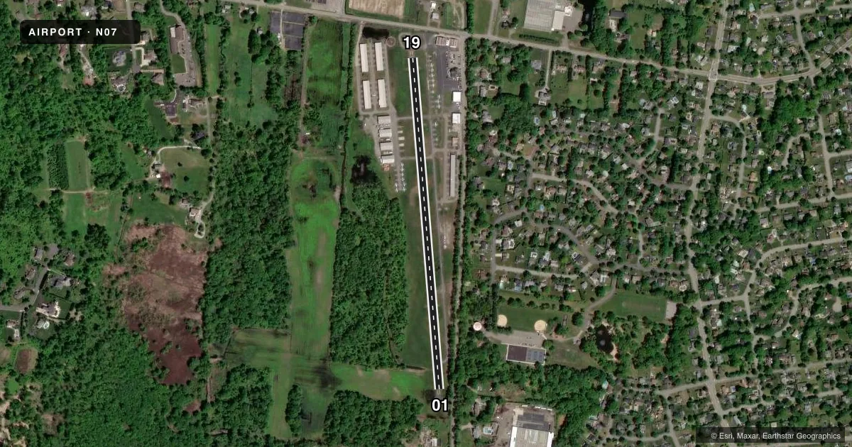
Airport sketch
Runways drawn to scale from FAA survey coordinates, rendered over satellite imagery. Not for navigation.
Approaches & charts
Services on the field
Fuel grades, oxygen, maintenance, ramp storage and lighting — as declared to the FAA by the airport operator.
Fuel & services
- Fuel
- 100LLA
- Oxygen (bottled)
- Low pressure
- Oxygen (bulk)
- Not available
- Airframe repair
- Major
- Power plant repair
- Major
- Other services
- CHTR,INSTR,RNTL,SALES
Ramp & ground
- Transient storage
- Tie-down
- Landing fee
- No fee published
- Customs
- Not available
- Lighting schedule
- SEE RMK
- Beacon schedule
- SS-SR
- Beacon
- White / Green (civil land)(WG)
- Wind indicator
- Yes
- Segmented circle
- No
Fuel & FBOs
Cheapest 100LL and Jet A on the field and nearby. Always confirm with the FBO before taxi.
Airport notes
Surface conditions, obstructions, local procedures, lighting outages and other notes published with each FAA cycle.
General notes
- NARROW TAXILANES & TWYS CAUSED BY NSTD CLNCS.
- DEER AND BIRDS INVOF RUNWAY.
- TOUCH AND GO LANDINGS PROHIBITED.
- GCO AVBL ON FREQ 121.725. IF UNABLE, CTC NEWARK APCH AT 800-645-3206.
- TSNT HEL OPS ALLOWED WITH PRE-APVL ONLY, CALL 973-628-7166.
Lighting notes
- ACTVT HIRL RY 01/19 - CTAF. ACTVT HIGH INTST FST WITH 7 CLICKS BFR ACTVTNG LOWER INTSTS.
Approach & departure obstructions
- 01+75 FT TREES 0-200 FT FROM RWY END 250 L - 250 R.
- 19+30 FT HGR 80 FT FROM RWY END 200 FT L.
- 01+50 FT TREE LINE 0-680 FT AND 90-160 FT R; APCH RATIO 0:1 BASED ON DSPLCD THLD.
- 19APCH RATIO 7:1 TO DSPLCD THLD.
Other notes
- ESTAB PRIOR TO 1936.
- MANAGERFBO CTC (973) 633-0450.
VFR map & nearby airports
VFR sectional. Tap any ICAO chip to open that airport.
Key facts · N07
Answer card- ICAO
- N07
- Name
- LINCOLN PARK
- Location
- LINCOLN PARK, NEW JERSEY
- Elevation
- 181 ft MSL
- Traffic pattern altitude
- 1,181 ft MSL (1,000 AGL)
- Control tower
- Non-towered (use CTAF)
- Total runways
- 1
- Longest runway
- 01/19 · 2,767 ft
- Published ILS approaches
- 0
- Published frequencies
- 4
- Magnetic variation
- 13°
- Current flight rules
- VFR
- Current wind
- 000° at 0 kt
- Favored runway now
- –
Lincoln Park Airport (N07) sits in Lincoln Park, New Jersey. Field elevation is 181 ft MSL. The airport has one runway. Runway 01/19 is 2,767 ft asphalt, which is the longest runway on the field. There is no control tower. CTAF and UNICOM are both 122.8. Newark Approach is on 127.6 and 379.9.
No ILS approaches are published here. Pattern altitude is not published, so use the standard 1,000 ft AGL for light piston traffic unless the current Chart Supplement says otherwise. The field has a few operational points to plan for. Touch and go landings are prohibited. Taxi lanes and taxiways are narrow because of nonstandard clearances. Deer and birds are reported in the area. There are also obstructions near both runway ends, including a hangar near runway 19 and tree lines near runway 01.
Lincoln Park Aviation is on the field. It carries AVGAS 100LL. Call (973) 633-0450 for current service details before you go. Runway 01/19 has high intensity lights that are activated by CTAF. Use 7 clicks to bring them on fast before selecting lower intensity. If you need ground communications outlet help, frequency 121.725 is listed. This is a small, constrained airport, so brief your taxi and landing plan before arrival.