METAR & TAF 4N1
4N1 does not publish a METAR.
Showing the nearest reporting station: KFWN (SUSSEX) · 13.2 NM away. Conditions at 4N1 may differ.
METAR · KFWN
Observed 04:53Z
KFWN 270453Z AUTO 32004KT 10SM FEW049 BKN110 21/17 A2985 RMK AO2 SLP104 T02060172 402890128 $
- Wind
- 320° @ 4 kt
- Visibility
- 10 SM
- Temp / Dew
- 21°C / 17°C
- Altimeter
- 29.85 inHg
- Clouds
- BKN
- Density alt
- 1,786 ft
- Ceiling
- 11,000 ft AGL
- Rules
- VFR
Airport info & contacts
Manager on record, flight service, ARTCC, attendance schedule and pattern altitude — published by the FAA and refreshed every 28 days.
Location
- From city
- 1 NM E
- VFR sectional
- NEW YORK
- ARTCC
- ZNY · NEW YORK
- NOTAM facility
- MIV (NOTAM-D)
Airport manager
- Name
- TIM WAGNER
- Phone
- 973-728-7721
- Address
- 126A AIRPORT RD BOX 1, WEST MILFORD NJ 07480
Flight service · Hours
- FSS MIV
- MILLVILLE1-800-WX-BRIEF
- Attendance
- 0800-1700
Frequencies
Tap any row to copy the frequency to your clipboard.
Runways & pattern
Full pagePattern entry · RWY 06
RIGHT TRAFFICRunway end performance
| End | TORA | TODA | ASDA | LDA | VGSI | Approach lights | Obstruction |
|---|---|---|---|---|---|---|---|
| 06 | — | — | — | — | — | — | 192', trees, 1988' from thr, 170' R of cntrln, slope 9 |
| 24 | — | — | — | — | PAPI 2-box left(3.5°) | — | 23', tree, 680' from thr, 132' R of cntrln, slope 20 |
Declared distances in feet. TORA = takeoff run available, TODA = takeoff distance, ASDA = accelerate-stop, LDA = landing distance.
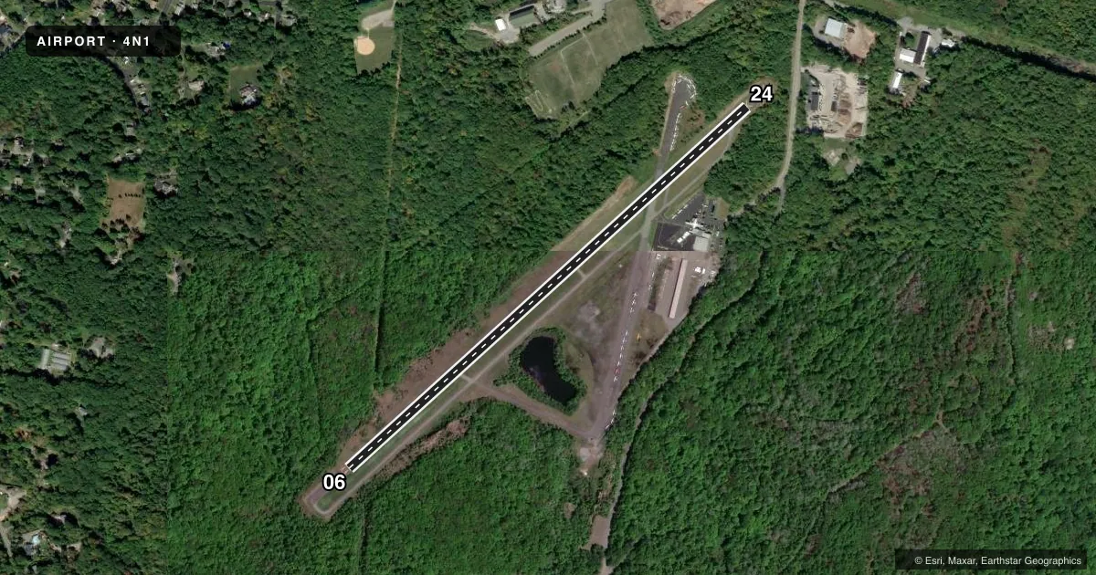
Airport sketch
Runways drawn to scale from FAA survey coordinates, rendered over satellite imagery. Not for navigation.
Approaches & charts
Services on the field
Fuel grades, oxygen, maintenance, ramp storage and lighting — as declared to the FAA by the airport operator.
Fuel & services
- Fuel
- 100LLA
- Oxygen (bottled)
- Not available
- Oxygen (bulk)
- Not available
- Airframe repair
- Major
- Power plant repair
- Major
- Other services
- AMB,INSTR,PAJA,RNTL,SALES
Ramp & ground
- Transient storage
- Tie-down
- Landing fee
- No fee published
- Customs
- Not available
- Lighting schedule
- SEE RMK
- Beacon schedule
- SS-SR
- Beacon
- White / Green (civil land)(WG)
- Wind indicator
- Lighted
- Segmented circle
- No
Fuel & FBOs
Cheapest 100LL and Jet A on the field and nearby. Always confirm with the FBO before taxi.
Airport notes
Surface conditions, obstructions, local procedures, lighting outages and other notes published with each FAA cycle.
General notes
- RY 06/24 STEEP ROCK LEDGES LCTD JUST BYD BOTH RY ENDS.
- ARPT SUBJECT TO GUSTING WIND & FREQUENT CROSSWINDS.
- SOME RWY AND TWY LGTS TALLER THAN STANDARD.
- DEER AND BIRDS ON AND INVOF ARPT.
- FOR CD CTC NEWARK APCH AT 800-645-3206.
- DROP ZONE LCTD SE SIDE OF RWY.
Lighting notes
- ACTVT MIRL RWY 06/24 - CTAF, 5 CLICKS. PAPI RWY 24 OPR CONSLY.
Approach & departure obstructions
- 06TREES BELOW RWY END, CLIFF.
Other notes
- RECOMMENDED THAT WIRES RWY 6 APCH BE MKD WITH PLASTIC BALLS OR PUT UNDERGND (WIRES NOW MKD & LGTS MOUNTED ON POLES).
- AUTOMATED UNICOM; 3 CLICKS TO ACTVT.
VFR map & nearby airports
VFR sectional. Tap any ICAO chip to open that airport.
Key facts · 4N1
Answer card- ICAO
- 4N1
- Name
- GREENWOOD LAKE
- Location
- WEST MILFORD, NEW JERSEY
- Elevation
- 789.6 ft MSL
- Traffic pattern altitude
- 1,789.6 ft MSL (1,000 AGL)
- Control tower
- Non-towered (use CTAF)
- Total runways
- 1
- Longest runway
- 06/24 · 3,471 ft
- Published ILS approaches
- 0
- Published frequencies
- 3
- Magnetic variation
- 13°
- Current flight rules
- VFR
- Current wind
- 320° at 4 kt
- Favored runway now
- RWY 06
Greenwood Lake Airport is in West Milford, New Jersey. The field elevation is 789.6 ft MSL. It has one runway, 06/24, which is 3,471 ft long and asphalt. There is no control tower. No ILS approaches are published. The pattern altitude is not published, so use the standard 1,000 ft AGL for light piston operations unless the current Chart Supplement says otherwise.
Greenwood Lake Airport has one on-field FBO. Greenwood Lake Airport carries 100LL and Jet A. Call (973) 728-7721 for current service details before you go. Automated UNICOM is available. Activate it with three microphone clicks. Runway 06/24 lighting is medium intensity and is activated on CTAF with five clicks. The PAPI on runway 24 operates continuously.
This is a field where the local conditions matter. Deer and birds are present on and near the airport. The runway and taxiway lights include some taller-than-standard fixtures. The airport is also known for gusting wind and frequent crosswinds. Runway 06 has trees below the end, plus a cliff. There are steep rock ledges just beyond both runway ends. Wires on the runway 6 approach are marked, with lights mounted on poles. For clearance delivery, contact Newark Approach. The drop zone is on the southeast side of the runway.