METAR & TAF KFWN
Current METAR
Observed 11:43Z
KFWN 271143Z AUTO 00000KT 2SM BR OVC002 19/ A2985 RMK AO2 VIS 1V3 T0189 $
- Wind
- 000° @ 0 kt
- Visibility
- 2 SM
- Temp / Dew
- —
- Altimeter
- 29.85 inHg
- Clouds
- OVC
- Density alt
- —
- Ceiling
- 200 ft AGL
- Rules
- LIFR
Airport info & contacts
Manager on record, flight service, ARTCC, attendance schedule and pattern altitude — published by the FAA and refreshed every 28 days.
Location
- From city
- 1 NM SW
- VFR sectional
- NEW YORK
- ARTCC
- ZNY · NEW YORK
- NOTAM facility
- MIV (NOTAM-D)
Airport manager
- Name
- JOHN MASSARI
- Phone
- (973) 702-1640
- Address
- PO BOX 311, SUSSEX NJ 07461
Flight service · Hours
- FSS MIV
- MILLVILLE1-800-WX-BRIEF
- Attendance
- 0830-1700
Frequencies
Tap any row to copy the frequency to your clipboard.
Runways & pattern
Full pagePattern entry · RWY 03
LEFT TRAFFICRunway end performance
| End | TORA | TODA | ASDA | LDA | VGSI | Approach lights | Obstruction |
|---|---|---|---|---|---|---|---|
| 03 | — | — | — | — | PAPI 2-box left(4°) | — | 50', trees, 250' from thr, 260' R of cntrln, slope 1 |
| 21 | — | — | — | — | — | — | 69', trees, 375' from thr, 79' R of cntrln, slope 2 |
Declared distances in feet. TORA = takeoff run available, TODA = takeoff distance, ASDA = accelerate-stop, LDA = landing distance.
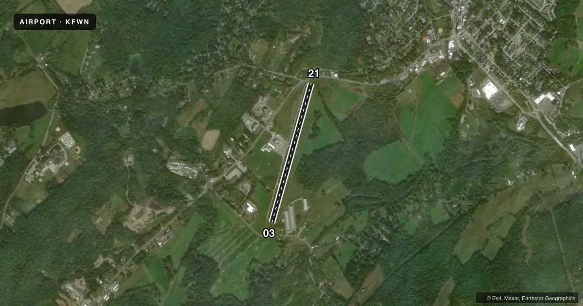
Airport sketch
Runways drawn to scale from FAA survey coordinates, rendered over satellite imagery. Not for navigation.
Approaches & charts
Services on the field
Fuel grades, oxygen, maintenance, ramp storage and lighting — as declared to the FAA by the airport operator.
Fuel & services
- Fuel
- 100LLA
- Oxygen (bottled)
- Not available
- Oxygen (bulk)
- Not available
- Airframe repair
- Not available
- Power plant repair
- Not available
- Other services
- AMB,AVNCS,INSTR,PAJA
Ramp & ground
- Transient storage
- Tie-down
- Landing fee
- Yes
- Customs
- Not available
- Lighting schedule
- SEE RMK
- Beacon schedule
- SS-SR
- Beacon
- White / Green (civil land)(WG)
- Wind indicator
- Lighted
- Segmented circle
- No
Fuel & FBOs
Cheapest 100LL and Jet A on the field and nearby. Always confirm with the FBO before taxi.
Airport notes
Surface conditions, obstructions, local procedures, lighting outages and other notes published with each FAA cycle.
General notes
- PAJA, DROP ZONE LCTD SW SIDE OF RWY.
- NON-STD TWY WIDTH, TWY AND RWY MRKGS. AIRCRAFT OPNS ON BLACKTOP ONLY.
- MAIN TWY SW 1500 FT CLSD.
- FOR CD CTC NEWARK APCH AT 800-645-3206.
- DEER AND BIRDS ON AND INVOF ARPT.
- NO TGL OR PLA ALLOWED.
Lighting notes
- DUSK-DAWN. ACTVT MIRL RWY 03/21 - CTAF.
Fuel notes
- ASELF-SVC.
Approach & departure obstructions
- 0315 FT TREE, 38 FT FM RWY END, 176 FT RIGHT.
- 2110 FT SIGN, 41 FT FM RWY END, 44 FT RIGHT.
- 03RWY 03 REIL OTS INDEFLY.
- 21RWY 21 REIL OTS INDEFLY.
- 03RWY 03 PAPI OTS INDEFLY.
- 03RWY 03 APCH RATIO 14:1 TO DSPLCD THR.
- 21RWY 21 APCH RATIO 16:1 TO DSPLCD THR.
Other notes
- BUILT PRIOR TO 1959.
VFR map & nearby airports
VFR sectional. Tap any ICAO chip to open that airport.
Key facts · KFWN
Answer card- ICAO
- KFWN
- Name
- SUSSEX
- Location
- SUSSEX, NEW JERSEY
- Elevation
- 421.6 ft MSL
- Traffic pattern altitude
- 1,421.6 ft MSL (1,000 AGL)
- Control tower
- Non-towered (use CTAF)
- Total runways
- 1
- Longest runway
- 03/21 · 3,506 ft
- Published ILS approaches
- 0
- Published frequencies
- 4
- Magnetic variation
- 13°
- Current flight rules
- LIFR
- Current wind
- 000° at 0 kt
- Favored runway now
- –
Sussex Airport is in Sussex, New Jersey. Field elevation is 421.6 ft MSL. It has one runway, 03/21, which is 3,506 ft long. The airport is non-towered. Traffic pattern altitude is not published, so use 1,000 ft AGL for light piston operations unless the current Chart Supplement says otherwise.
There are no published ILS approaches here. For clearance delivery, Newark Approach is listed in the remarks. The airport uses UNICOM and CTAF 122.7. Runway 03 REIL is out of service indefinitely. Runway 21 REIL is also out of service indefinitely. The main taxiway southwest 1,500 ft is closed. Taxiway width and runway markings are non-standard. Aircraft operations are permitted on blacktop only.
No on-field FBOs are listed. Self-serve fuel is available. Verify current fuel availability with the airport operator or the FBO directly by phone before you go. A parachute jump aircraft and drop zone are on the southwest side of the runway. Deer and birds are reported on and near the airport. Runway 03 and 21 both have published approach clearance slope notes to the displaced threshold, so pay close attention on arrival. This is an older field built before 1959, so expect a layout that may not feel standard if you have not been here before.