METAR & TAF 1N7
1N7 does not publish a METAR.
Showing the nearest reporting station: KMPO (POCONO MOUNTAINS RGNL) · 20.0 NM away. Conditions at 1N7 may differ.
METAR · KMPO
Observed 10:53Z
KMPO 271053Z AUTO 9SM 16/15 A2989 RMK AO2 SLP113 T01560150
- Wind
- Calm
- Visibility
- 9 SM
- Temp / Dew
- 16°C / 15°C
- Altimeter
- 29.89 inHg
- Clouds
- Clear
- Density alt
- 618 ft
- Ceiling
- Unlimited
- Rules
- VFR
Airport info & contacts
Manager on record, flight service, ARTCC, attendance schedule and pattern altitude — published by the FAA and refreshed every 28 days.
Location
- From city
- 2 NM SW
- VFR sectional
- NEW YORK
- ARTCC
- ZNY · NEW YORK
- NOTAM facility
- MIV (NOTAM-D)
Airport manager
- Name
- DENNIS KIERNAN
- Phone
- 908-362-8965
- Address
- 36 LAMBERT RD., BLAIRSTOWN NJ 07825
Flight service · Hours
- FSS MIV
- MILLVILLE1-800-WX-BRIEF
- Attendance
- 0700-1800
Frequencies
Tap any row to copy the frequency to your clipboard.
Runways & pattern
Full pagePattern entry · RWY 07
LEFT TRAFFICRunway end performance
| End | TORA | TODA | ASDA | LDA | VGSI | Approach lights | Obstruction |
|---|---|---|---|---|---|---|---|
| 07 | — | — | — | — | — | — | 77', trees, 225' from thr, 198' R of cntrln, slope 0 |
| 25 | — | — | — | — | — | — | 25', trees, 207' from thr, 31' R of cntrln, slope 0 |
Declared distances in feet. TORA = takeoff run available, TODA = takeoff distance, ASDA = accelerate-stop, LDA = landing distance.
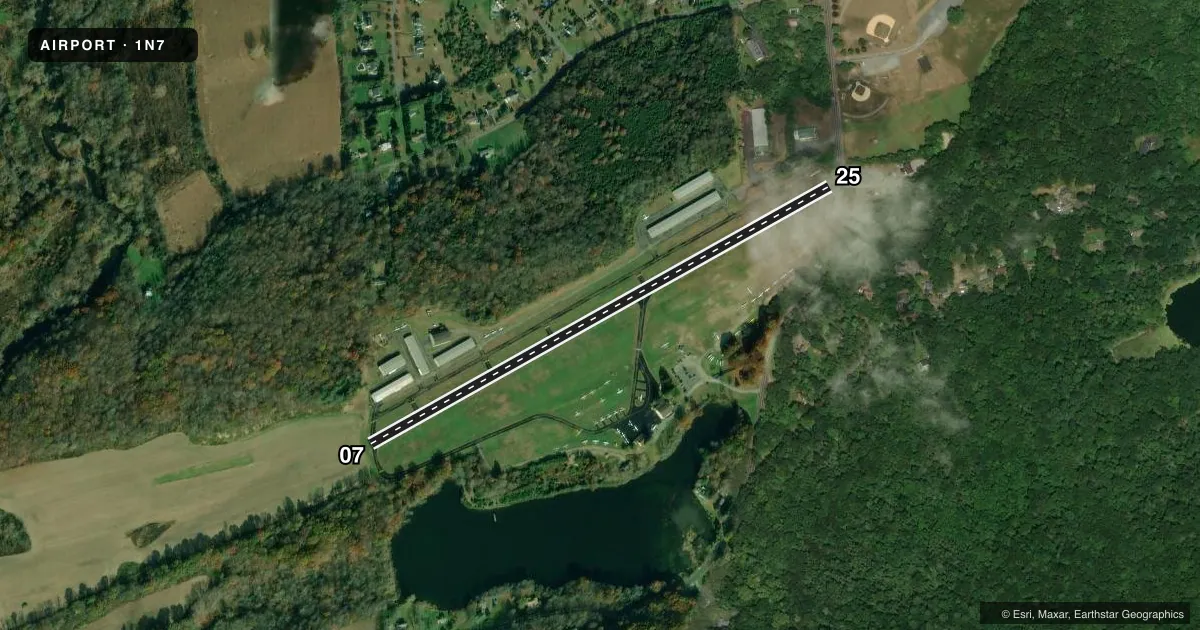
Airport sketch
Runways drawn to scale from FAA survey coordinates, rendered over satellite imagery. Not for navigation.
Approaches & charts
Services on the field
Fuel grades, oxygen, maintenance, ramp storage and lighting — as declared to the FAA by the airport operator.
Fuel & services
- Fuel
- 100LL
- Oxygen (bottled)
- Not available
- Oxygen (bulk)
- Low pressure
- Airframe repair
- Major
- Power plant repair
- Major
- Other services
- GLD,INSTR,TOW
Ramp & ground
- Transient storage
- Tie-down
- Landing fee
- No fee published
- Customs
- Not available
- Lighting schedule
- SS-SR
- Beacon schedule
- SS-SR
- Beacon
- White / Green (civil land)(WG)
- Wind indicator
- Lighted
- Segmented circle
- No
Fuel & FBOs
Cheapest 100LL and Jet A on the field and nearby. Always confirm with the FBO before taxi.
Airport notes
Surface conditions, obstructions, local procedures, lighting outages and other notes published with each FAA cycle.
General notes
- GLIDERS & TOW AIRPLANES OPERATE FM TURF AREA JUST SOUTH OF RY 07/25.
- TREES IN THE 7:1 TRANSITIONAL AREA ALONG RUNWAY SIDES.
- HILL EAST OF ARPT MAY REQUIRE PILOTS TO EXECUTE STEEP APCH TO RY 25.
- FOR CD CTC ALLENTOWN APCH AT 800-728-6322.
Fuel notes
- 100LL24 HOUR SELF SERVICE
Approach & departure obstructions
- 07+95 FT TREE, 4 FT FROM RY END, 225 FT L
- 25+33FT TREE, 23 FT FM RWY END, 145 FT R
- 07RY 07 APCH RATIO 2:1 TO THE DSPLCD THLD.
- 25RY 25 APCH RATIO 0:1 TO THE DSPLCD THLD.
Other notes
- ESTAB PRIOR TO 1940.
VFR map & nearby airports
VFR sectional. Tap any ICAO chip to open that airport.
Key facts · 1N7
Answer card- ICAO
- 1N7
- Name
- BLAIRSTOWN
- Location
- BLAIRSTOWN, NEW JERSEY
- Elevation
- 371.5 ft MSL
- Traffic pattern altitude
- 1,371.5 ft MSL (1,000 AGL)
- Control tower
- Non-towered (use CTAF)
- Total runways
- 1
- Longest runway
- 07/25 · 3,112 ft
- Published ILS approaches
- 0
- Published frequencies
- 6
- Magnetic variation
- 13°
- Current flight rules
- VFR
- Current wind
- Calm / unavailable
- Favored runway now
- –
Blairstown Airport (1N7) sits in Blairstown, New Jersey. Field elevation is 371.5 ft MSL. The airport has one runway, 07/25, which is 3,112 ft long. There is no control tower. Pattern altitude is not published, so use the standard 1,000 ft AGL for light piston traffic unless the current Chart Supplement says otherwise.
There are no ILS approaches published here. The field uses CTAF 123.0 for local traffic. Medium intensity runway lights on 07/25 are activated by CTAF. JD Air is on the field and carries 100LL. 100LL is also available 24 hours by self-serve. If you need clearance delivery, the published remark points pilots to Allentown Approach.
A first-time pilot should pay close attention to the terrain and obstacles. The hill east of the airport can make runway 25 feel steep on approach. Published remarks also note obstacle clearance issues near both runway ends. Runway 25 has a tree close to the departure end. Runway 07 has a taller tree near the threshold area. Gliders and tow airplanes also operate from the turf area just south of 07/25. That makes traffic scanning important on arrival and departure.