METAR & TAF 8N4
8N4 does not publish a METAR.
Showing the nearest reporting station: KMPO (POCONO MOUNTAINS RGNL) · 7.6 NM away. Conditions at 8N4 may differ.
METAR · KMPO
Observed 09:53Z
KMPO 270953Z AUTO 31005KT 10SM 16/14 A2988 RMK AO2 SLP108 T01560144
- Wind
- 310° @ 5 kt
- Visibility
- 10 SM
- Temp / Dew
- 16°C / 14°C
- Altimeter
- 29.88 inHg
- Clouds
- Clear
- Density alt
- 1,943 ft
- Ceiling
- Unlimited
- Rules
- VFR
Airport info & contacts
Manager on record, flight service, ARTCC, attendance schedule and pattern altitude — published by the FAA and refreshed every 28 days.
Location
- From city
- 2 NM N
- VFR sectional
- NEW YORK
- ARTCC
- ZNY · NEW YORK
- NOTAM facility
- IPT (NOTAM-D)
Airport manager
- Name
- DAVID TURNER
- Phone
- 646-298-4753
- Address
- 360 DUTCH HILL RD., CANADENSIS PA 18325
Flight service · Hours
- FSS IPT
- WILLIAMSPORT1-800-WX-BRIEF
- Attendance
- IRREG
Frequencies
Tap any row to copy the frequency to your clipboard.
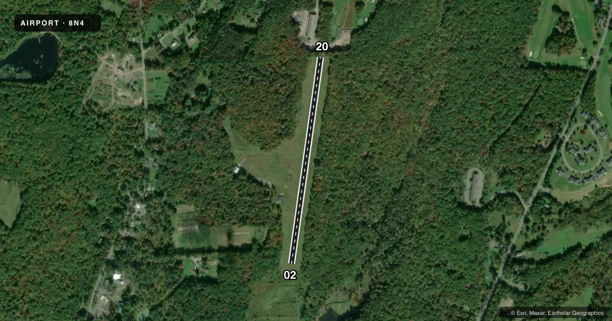
Runways & pattern
Full pagePattern entry · RWY 02
LEFT TRAFFICRunway end performance
| End | TORA | TODA | ASDA | LDA | VGSI | Approach lights | Obstruction |
|---|---|---|---|---|---|---|---|
| 20 | — | — | — | — | — | — | 86', trees, 27' from thr, 29' R of cntrln, slope 0 |
Declared distances in feet. TORA = takeoff run available, TODA = takeoff distance, ASDA = accelerate-stop, LDA = landing distance.
Airport sketch
Runways drawn to scale from FAA survey coordinates, rendered over satellite imagery. Not for navigation.
Approaches & charts
Services on the field
Fuel grades, oxygen, maintenance, ramp storage and lighting — as declared to the FAA by the airport operator.
Fuel & services
- Fuel
- Not available
- Oxygen (bottled)
- Not available
- Oxygen (bulk)
- Not available
- Airframe repair
- Not available
- Power plant repair
- Not available
Ramp & ground
- Transient storage
- Not published
- Landing fee
- No fee published
- Wind indicator
- Yes
- Segmented circle
- No
Fuel & FBOs
Cheapest 100LL and Jet A on the field and nearby. Always confirm with the FBO before taxi.
Airport notes
Surface conditions, obstructions, local procedures, lighting outages and other notes published with each FAA cycle.
General notes
- LDG PROHIBITED RWY 20; DEP PROHIBITED RWY 02.
- NO SNOW REMOVAL.
- DEER & WILDLIFE ON AND INVOF RWY.
- ANNOUNCE TFC ON CTAF 122.9.
- FOR CD CTC WILKES-BARRE APCH AT 570-655-2084.
Approach & departure obstructions
- 02RY 02/20 MARKED WITH WHITE CONES.
- 02CTLNG OBSTN EXCEEDS A 45 DEG SLP.
VFR map & nearby airports
VFR sectional. Tap any ICAO chip to open that airport.
Key facts · 8N4
Answer card- ICAO
- 8N4
- Name
- FLYING DOLLAR
- Location
- CANADENSIS, PENNSYLVANIA
- Elevation
- 1,430 ft MSL
- Traffic pattern altitude
- 2,430 ft MSL (1,000 AGL)
- Control tower
- Non-towered (use CTAF)
- Total runways
- 1
- Longest runway
- 02/20 · 2,405 ft
- Published ILS approaches
- 0
- Published frequencies
- 1
- Magnetic variation
- 12°
- Current flight rules
- VFR
- Current wind
- 310° at 5 kt
- Favored runway now
- RWY 02
FLYING DOLLAR (8N4) sits in Canadensis, Pennsylvania at 1,430 ft MSL. It has one runway. Runway 02/20 is a 2,405 ft turf strip. There is no control tower. CTAF is 122.9. No ILS approaches are published.
The published pattern altitude is not listed, so use the standard 1,000 ft AGL for light piston operations unless the current FAA Chart Supplement says otherwise. That puts the traffic pattern at about 2,430 ft MSL. The field has a magnetic variation of 12°. Runway headings are 8° and 188° magnetic.
There are no on-field FBOs listed. Check with the airport operator or the FBO directly by phone before arrival if you need fuel or other services. Published remarks matter here. Runway 02 has a controlling obstruction that exceeds a 45 degree slope. Landing is prohibited on runway 20. Departure is prohibited on runway 02. Runways 02 and 20 are marked with white cones. No snow removal is provided. Deer and other wildlife are reported on and near the runway. For clearance delivery, contact Wilkes-Barre Approach at 570-655-2084. For traffic calls, announce on CTAF 122.9.