METAR & TAF KMPO
Current METAR
Observed 23:53Z
KMPO 232353Z AUTO 32008G19KT 10SM CLR 19/11 A2997 RMK AO2 SLP143 T01890111 10206 20167 53011 $
- Wind
- 320° @ 8G19 kt
- Visibility
- 10 SM
- Temp / Dew
- 19°C / 11°C
- Altimeter
- 29.97 inHg
- Clouds
- CLR
- Density alt
- 2,793 ft
- Ceiling
- Unlimited
- Rules
- VFR
Airport info & contacts
Manager on record, flight service, ARTCC, attendance schedule and pattern altitude — published by the FAA and refreshed every 28 days.
Location
- From city
- 2 NM NW
- VFR sectional
- NEW YORK
- ARTCC
- ZNY · NEW YORK
- NOTAM facility
- MPO (NOTAM-D)
Airport manager
- Name
- JUSTIN KLEIN
- Phone
- (570) 839-0258
- Address
- 188 AIRPORT DR, TOBYHANNA PA 18466
Flight service · Hours
- FSS IPT
- WILLIAMSPORT1-800-WX-BRIEF
- Attendance
- 0700-1700
Frequencies
Tap any row to copy the frequency to your clipboard.
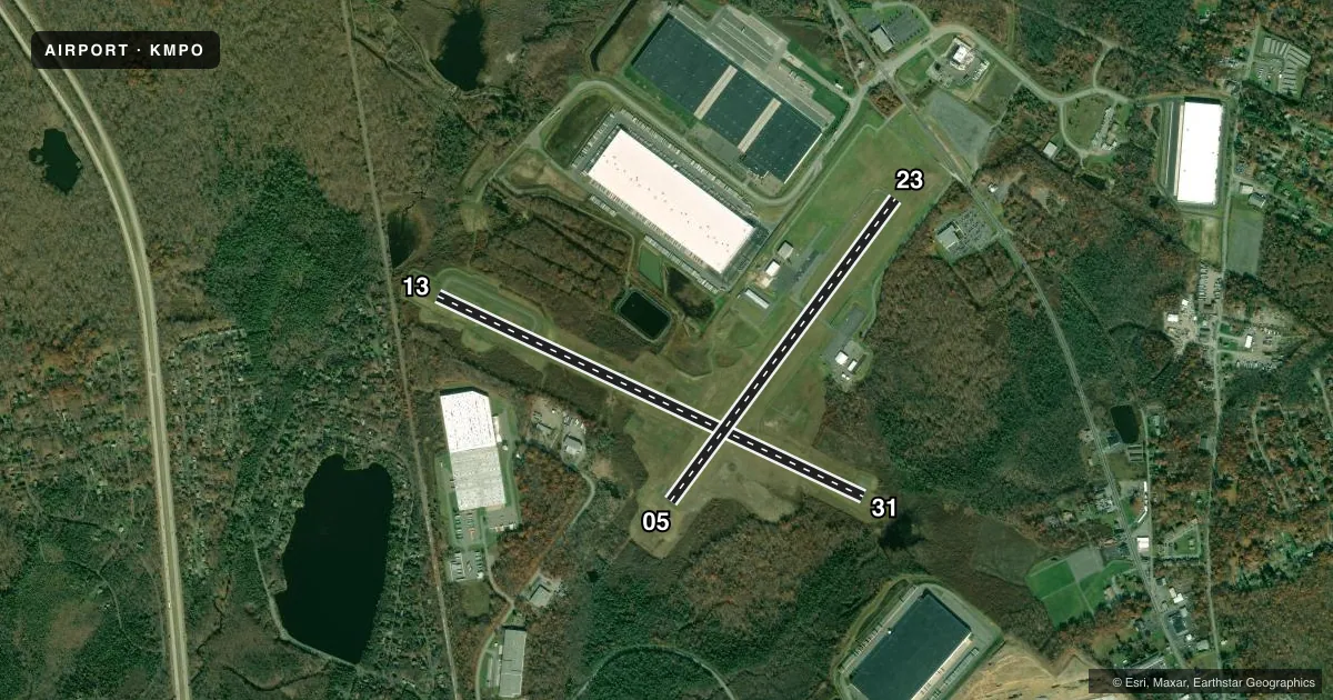
Runways & pattern
Full pagePattern entry · RWY 31
LEFT TRAFFIC| Runway | Heading (°M) | Length | Surface | Traffic |
|---|---|---|---|---|
| 13/31Favored | 102° / 282° | 5,001 ft | ASPH | Standard L |
| 05/23 | 24° / 204° | 3,999 ft | ASPH | Standard L |
Runway end performance
| End | TORA | TODA | ASDA | LDA | VGSI | Approach lights | Obstruction |
|---|---|---|---|---|---|---|---|
| 13 | — | — | — | — | PAPI 2-box left(3°) | — | 44', trees, 671' from thr, 284' R of cntrln, slope 10 |
| 31 | — | — | — | — | PAPI 2-box left(3.5°) | — | 102', trees, 2921' from thr, 200' R of cntrln, slope 26 |
| 05 | — | — | — | — | PAPI 2-box left(4°) | — | 26', trees, 599' from thr, 149' R of cntrln, slope 15 |
| 23 | — | — | — | — | PAPI 2-box left(4°) | — | 37', road, 733' from thr, 0' R of cntrln, slope 14 |
Declared distances in feet. TORA = takeoff run available, TODA = takeoff distance, ASDA = accelerate-stop, LDA = landing distance.
Airport sketch
Runways drawn to scale from FAA survey coordinates, rendered over satellite imagery. Not for navigation.
Approaches & charts
Services on the field
Fuel grades, oxygen, maintenance, ramp storage and lighting — as declared to the FAA by the airport operator.
Fuel & services
- Fuel
- 100LLA
- Oxygen (bottled)
- Not available
- Oxygen (bulk)
- Not available
- Airframe repair
- Major
- Power plant repair
- Major
- Other services
- CHTR,INSTR,RNTL
Ramp & ground
- Transient storage
- Tie-down
- Hangar
- Landing fee
- No fee published
- Customs
- Not available
- Lighting schedule
- SEE RMK
- Beacon schedule
- SS-SR
- Beacon
- White / Green (civil land)(WG)
- Wind indicator
- Lighted
- Segmented circle
- Yes
Fuel & FBOs
Cheapest 100LL and Jet A on the field and nearby. Always confirm with the FBO before taxi.
Airport notes
Surface conditions, obstructions, local procedures, lighting outages and other notes published with each FAA cycle.
General notes
- BIRDS, DEER & OTHER WILDLIFE ON & INVOF ARPT.
- RWY 31 VFR DEP: FLY HDG 310 TILL CROSSING INTERSTATE 380, THEN PROCEED ON CRS AVOIDING OVERFLIGHT OF HOMES SW OF RWY 13-31.
- FOR SVC AFT HRS CALL 570-807-8966.
Lighting notes
- ACTVT REIL RWY 05, 13, 23 & 31; PAPI RWY 05, 13, 23 & 31; MIRL RWY 05/23 & 13/31 - CTAF.
Fuel notes
- 100LL24 HR SELF SVC 100LL AVAIL.
Approach & departure obstructions
- 1326:1 SLP TO DTHR.
Other notes
- UNICOM 0800-DUSK DLY.
VFR map & nearby airports
VFR sectional. Tap any ICAO chip to open that airport.
Key facts · KMPO
Answer card- ICAO
- KMPO
- Name
- POCONO MOUNTAINS RGNL
- Location
- MOUNT POCONO, PENNSYLVANIA
- Elevation
- 1,915.2 ft MSL
- Traffic pattern altitude
- 2,915.2 ft MSL (1,000 AGL)
- Control tower
- Non-towered (use CTAF)
- Total runways
- 2
- Longest runway
- 13/31 · 5,001 ft
- Published ILS approaches
- 0
- Published frequencies
- 5
- Magnetic variation
- 13°
- Current flight rules
- VFR
- Current wind
- 320° at 8 kt
- Favored runway now
- RWY 31
Pocono Mountains RGNL sits in Mount Pocono, Pennsylvania. Field elevation is 1,915.2 ft MSL. The airport has two asphalt runways. The longest is 13/31 at 5,001 ft. There is no control tower. No ILS approaches are published. The pattern altitude is not published, so use the standard 1,000 ft AGL for light piston traffic unless the current Chart Supplement says otherwise.
Pocono Mountains Municipal Airport is the on-field FBO. It carries 100LL and Jet A PRIST. 24-hour self-serve 100LL is available. For after-hours service, the published remark says to call the airport number.
This is a mountain airport with wildlife activity noted on and near the field. Expect birds and deer. Runway 13 has a displaced threshold with a published 26 to 1 slope to that threshold. Runway end identifier lights, PAPI and medium intensity runway lights are published on both runways. The lights are tied to CTAF control. UNICOM is listed as available from 0800 to dusk daily. For VFR departure from runway 31, the published routing is to fly heading 310 degrees until crossing Interstate 380. Then continue on course while avoiding homes southwest of runway 13/31. Check the current Chart Supplement for any noise or curfew restrictions before flying in.