METAR & TAF N43
N43 does not publish a METAR.
Showing the nearest reporting station: KABE (LEHIGH VALLEY INTL) · 10.5 NM away. Conditions at N43 may differ.
METAR · KABE
Observed 07:51Z
KABE 270751Z 00000KT 10SM FEW090 SCT110 19/18 A2983 RMK AO2 SLP098 T01940183 $
- Wind
- 000° @ 0 kt
- Visibility
- 10 SM
- Temp / Dew
- 19°C / 18°C
- Altimeter
- 29.83 inHg
- Clouds
- SCT
- Density alt
- 1,084 ft
- Ceiling
- Unlimited
- Rules
- VFR
Airport info & contacts
Manager on record, flight service, ARTCC, attendance schedule and pattern altitude — published by the FAA and refreshed every 28 days.
Location
- From city
- 3 NM N
- VFR sectional
- NEW YORK
- ARTCC
- ZNY · NEW YORK
- NOTAM facility
- IPT (NOTAM-D)
Airport manager
- Name
- THOMAS R. STOUDT
- Phone
- 610-231-5270
- Address
- BRADEN AIRPARK, 3800 SULLIVAN TRAIL, EASTON PA 18040
Flight service · Hours
- FSS IPT
- WILLIAMSPORT1-800-WX-BRIEF
- Attendance
- 0800-1630
Frequencies
Tap any row to copy the frequency to your clipboard.
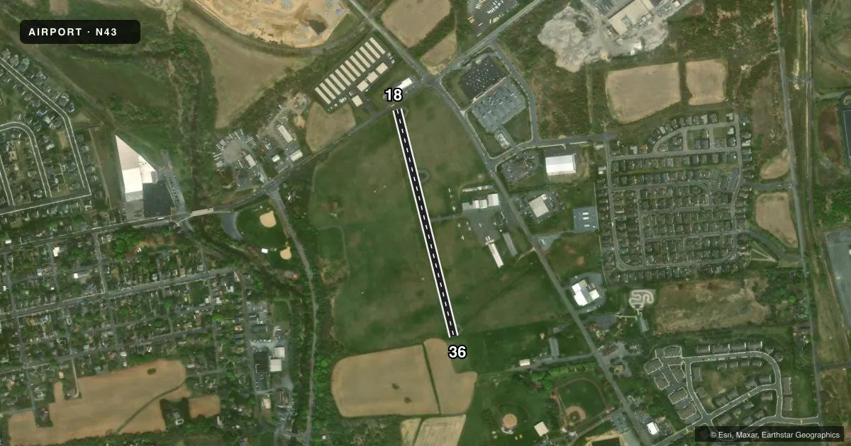
Runways & pattern
Full pagePattern entry · RWY 18
LEFT TRAFFICRunway end performance
| End | TORA | TODA | ASDA | LDA | VGSI | Approach lights | Obstruction |
|---|---|---|---|---|---|---|---|
| 18 | — | — | — | — | — | — | 26', trees, 415' from thr, 221' R of cntrln, slope 8 |
| 36 | — | — | — | — | — | — | 28', trees, 685' from thr, 121' R of cntrln, slope 17 |
Declared distances in feet. TORA = takeoff run available, TODA = takeoff distance, ASDA = accelerate-stop, LDA = landing distance.
Airport sketch
Runways drawn to scale from FAA survey coordinates, rendered over satellite imagery. Not for navigation.
Approaches & charts
Services on the field
Fuel grades, oxygen, maintenance, ramp storage and lighting — as declared to the FAA by the airport operator.
Fuel & services
- Fuel
- 100LL
- Oxygen (bottled)
- Not available
- Oxygen (bulk)
- Not available
- Airframe repair
- Minor
- Power plant repair
- Minor
Ramp & ground
- Transient storage
- Tie-down
- Hangar
- Landing fee
- No fee published
- Customs
- Not available
- Beacon schedule
- SS-SR
- Beacon
- White / Green (civil land)(WG)
- Wind indicator
- Lighted
- Segmented circle
- No
Fuel & FBOs
Cheapest 100LL and Jet A on the field and nearby. Always confirm with the FBO before taxi.
Airport notes
Surface conditions, obstructions, local procedures, lighting outages and other notes published with each FAA cycle.
General notes
- ACFT MAY NOT BE VISIBLE ON ALL PARTS OF FIELD.
- FOR CD CTC ALLENTOWN APCH AT 800-728-6322.
Fuel notes
- 100LL24 HR SELF-SERVE FUEL AVAILABLE.
Runway surface & condition
- 18/36RWY 18/36 NSTD LIRL LGTS SPCD AT 400 FT INTERVALS.
- 18/36RY 18/36 1956 FT BY 50 FT ASPH ALIGNED IN CNTR OF 165 FT TURF STRIP.
Approach & departure obstructions
- 18APCH RATIO 22:1 TO DTHR.
Other notes
- THIS AIRPORT HAS BEEN SURVEYED BY THE NATIONAL GEODETIC SURVEY.
- EST PRIOR TO 1959.
VFR map & nearby airports
VFR sectional. Tap any ICAO chip to open that airport.
Key facts · N43
Answer card- ICAO
- N43
- Name
- BRADEN AIRPARK
- Location
- EASTON, PENNSYLVANIA
- Elevation
- 396.8 ft MSL
- Traffic pattern altitude
- 1,396.8 ft MSL (1,000 AGL)
- Control tower
- Non-towered (use CTAF)
- Total runways
- 1
- Longest runway
- 18/36 · 1,956 ft
- Published ILS approaches
- 0
- Published frequencies
- 5
- Magnetic variation
- 13°
- Current flight rules
- VFR
- Current wind
- 000° at 0 kt
- Favored runway now
- –
Braden Airpark sits in Easton, Pennsylvania. Field elevation is 396.8 ft MSL. It has one runway, 18/36, which is 1,956 ft long. The field is not towered. CTAF and UNICOM are both 123.0. Approach, departure and clearance services are handled by Allentown frequencies listed in the Chart Supplement. No ILS approaches are published here.
Pattern altitude is not published. Use 1,000 ft AGL for light piston operations unless the current Chart Supplement says otherwise. The runway is asphalt in the center of a turf strip. Published remarks also note nonstandard low-intensity runway lights spaced at 400 ft intervals. Runway 18 has an approach ratio of 22 to 1 to the displaced threshold. Brief the arrival carefully.
Lehigh Valley Aviation Services is on the field. It carries AVGAS 100LL. Twenty-four hour self-serve fuel is available. One published remark says aircraft may not be visible on all parts of the field. Do a careful taxi and ramp scan. This is a small, non-towered airport near a populated part of Pennsylvania. Expect to work the radio. Keep an eye out for local traffic. Verify current procedures before you go.