METAR & TAF KABE
Current METAR
Observed 06:51Z
KABE 280651Z 00000KT 10SM CLR 18/17 A2975 RMK AO2 SLP072 T01830172
- Wind
- 000° @ 0 kt
- Visibility
- 10 SM
- Temp / Dew
- 18°C / 17°C
- Altimeter
- 29.75 inHg
- Clouds
- CLR
- Density alt
- 1,059 ft
- Ceiling
- Unlimited
- Rules
- VFR
Airport info & contacts
Manager on record, flight service, ARTCC, attendance schedule and pattern altitude — published by the FAA and refreshed every 28 days.
Location
- From city
- 3 NM NE
- VFR sectional
- NEW YORK
- ARTCC
- ZNY · NEW YORK
- NOTAM facility
- ABE (NOTAM-D)
Airport manager
- Name
- THOMAS R. STOUDT
- Phone
- 610-266-6001
- Address
- 3311 AIRPORT RD, ALLENTOWN PA 18109-3040
Flight service · Hours
- FSS IPT
- WILLIAMSPORT1-800-WX-BRIEF
- Attendance
- ALL
Frequencies
Tap any row to copy the frequency to your clipboard.
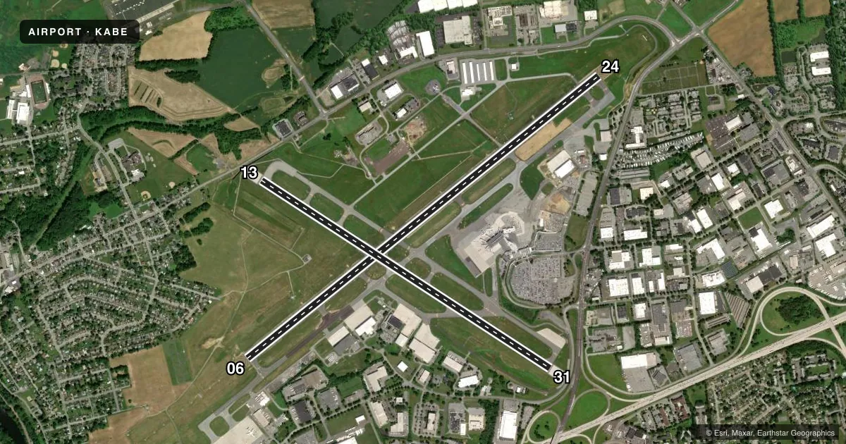
Runways & pattern
Full pagePattern entry · RWY 06
LEFT TRAFFIC| Runway | Heading (°M) | Length | Surface | Traffic |
|---|---|---|---|---|
| 06/24 | 39° / 219° | 7,599 ft | ASPH | Standard L |
| 13/31 | 111° / 291° | 5,800 ft | ASPH | Standard L |
Runway end performance
| End | TORA | TODA | ASDA | LDA | VGSI | Approach lights | Obstruction |
|---|---|---|---|---|---|---|---|
| 06 | 7,599' | 7,599' | 7,599' | 7,599' | PAPI 4-box left(3°) | MALSR | 55', trees, 2689' from thr, 720' R of cntrln, slope 45 |
| 24 | 7,599' | 7,599' | 7,599' | 7,089' | PAPI 4-box right(3°) | — | 24', road, 659' from thr, 549' R of cntrln, slope 19 |
| 13 | 5,800' | 5,800' | 5,800' | 5,800' | — | MALSR | — |
| 31 | 5,800' | 5,800' | 5,800' | 5,800' | PAPI 4-box left(3°) | — | 25', pole, 272' from thr, 420' R of cntrln, slope 2 |
Declared distances in feet. TORA = takeoff run available, TODA = takeoff distance, ASDA = accelerate-stop, LDA = landing distance.
Airport sketch
Runways drawn to scale from FAA survey coordinates, rendered over satellite imagery. Not for navigation.
Approaches & charts
ILS · 3
Services on the field
Fuel grades, oxygen, maintenance, ramp storage and lighting — as declared to the FAA by the airport operator.
Fuel & services
- Fuel
- 100LLA
- Oxygen (bottled)
- Not available
- Oxygen (bulk)
- HIGH/LOW
- Airframe repair
- Major
- Power plant repair
- Major
- Other services
- AFRT,AMB,AVNCS,CARGO,CHTR,INSTR,RNTL
Ramp & ground
- Transient storage
- Tie-down
- Hangar
- Landing fee
- Yes
- Customs
- Not available
- Beacon schedule
- SS-SR
- Beacon
- White / Green (civil land)(WG)
- Wind indicator
- Lighted
- Segmented circle
- No
Fuel & FBOs
Cheapest 100LL and Jet A on the field and nearby. Always confirm with the FBO before taxi.
Airport notes
Surface conditions, obstructions, local procedures, lighting outages and other notes published with each FAA cycle.
General notes
- MIL ACFT PLAN TO PARK & REFUEL ON THE HANGAR-7 APRON.
- BIRDS; GROUNDHOGS & DEER ON & INVOF ARPT.
- FLIGHT NOTIFICATION SERVICE (ADCUS) AVBL - 2 HR PPR.
- TWY C RSTD TO MAXIMUM ACFT WEIGHT 12500 LBS.
- NOISE ABATEMENT PROCEDURES FOR TURBOJET POWERED ACFT IN EFFECT; PREFERENTIAL RY 06/24.
- RY 06 & 24 FLY RY HEADING UNTIL 2000 FT.
- RY 6 13 & 24 DEPS BE ADVISED THAT DEPS ARE OVER A NOISE SENSITIVE AREA.
- RY 31 TURBOJET DEPS TURN RIGHT HEADING 360 DEGS UNTIL 2000 FT MSL.
- TPA 1400 FT MSL (1006 FT AGL) RECIPROCATING PROPS; 2000 FT MSL (1606 FT AGL) TURBINE POWERED ACFT.
- TWY B SOUTH OF TWY B3 RSTRD TO ACFT WITH WINGSPAN 118 FT OR LESS.
- TWY E RSTD TO ACFT MAX GWT 12500 LBS.
- TWY J RSTD TO ACFT WITH 118 FT WINGSPAN OR LESS.
- TWY B3 WEST OF RY 13/31 RSTRD TO ACFT WITH WINGSPAN 118 FT OR LESS.
- DURING ATC ZERO EVENTS, ARFF WILL MNT 120.5 FOR EMERG NOTIFICATIONS.
Runway surface & condition
- 06/24PCR VALUE: 630/F/C/X/T
- 13/31PCR VALUE: 150/F/D/X/T
Approach & departure obstructions
- 24RY 24 HAS APCH RATIO 47:1 TO DSPLCD THLD AND ROADWAY 540 FT RIGHT & 431 FT LEFT & 654 FT FM RY 24 END.
Arresting gear
- 13_EMASNON-STD ENGINEERED MATERIALS ARRESTING SYSTEM (EMAS) WITH 35 FT SETBACK 251 FT IN LENGTH BY 170 FT IN WIDTH LCTD AT THE DER 13.
- 31_EMASNON-STD ENGINEERED MATERIALS ARRESTING SYSTEM (EMAS) WITH 35 FT SETBACK 263 FT IN LENGTH BY 170 FT IN WIDTH LCTD AT THE DER 31.
VFR map & nearby airports
VFR sectional. Tap any ICAO chip to open that airport.
Key facts · KABE
Answer card- ICAO
- KABE
- Name
- LEHIGH VALLEY INTL
- Location
- ALLENTOWN, PENNSYLVANIA
- Elevation
- 393.7 ft MSL
- Traffic pattern altitude
- 1,393.7 ft MSL (1,000 AGL)
- Control tower
- Towered · 24
- Total runways
- 2
- Longest runway
- 06/24 · 7,599 ft
- Published ILS approaches
- 3
- Published frequencies
- 17
- Magnetic variation
- 12°
- Current flight rules
- VFR
- Current wind
- 000° at 0 kt
- Favored runway now
- –
Lehigh Valley Intl is in Allentown, Pennsylvania. Field elevation is 393.7 ft MSL. The airport has two asphalt runways. The longest is 7,599 ft on 06/24. The control tower is open 24 hours. Three ILS approaches are published for runway ends 06, 13 and 24.
Pattern altitude is published at 1,400 ft MSL for reciprocating propeller aircraft. That is 1,006 ft AGL. Turbine aircraft use 2,000 ft MSL. That is 1,606 ft AGL. Lehigh Valley Aviation Services is on the field. It carries 100LL, Jet A and Jet A Prist. If you are planning a stop, that is the FBO to call for current ramp and fuel details.
A few operational items matter here. Noise abatement is in effect for turbojet aircraft. Preferential runway use is 06/24. Turbojet departures from runway 31 call for a right turn to heading 360° until 2,000 ft MSL. Taxiway C is limited to aircraft at or under 12,500 pounds. Birds, groundhogs and deer are reported on and near the airport. Runway 24 also has a published roadway obstruction note near the approach area. Check the current FAA Chart Supplement before arrival if you need the latest airport remarks or any restriction details.