METAR & TAF P91
P91 does not publish a METAR.
Showing the nearest reporting station: KABE (LEHIGH VALLEY INTL) · 13.1 NM away. Conditions at P91 may differ.
METAR · KABE
Observed 03:51Z
KABE 270351Z 25006KT 10SM CLR 22/17 A2985 RMK AO2 SLP105 T02220172 $
- Wind
- 250° @ 6 kt
- Visibility
- 10 SM
- Temp / Dew
- 22°C / 17°C
- Altimeter
- 29.85 inHg
- Clouds
- CLR
- Density alt
- 1,838 ft
- Ceiling
- Unlimited
- Rules
- VFR
Airport info & contacts
Manager on record, flight service, ARTCC, attendance schedule and pattern altitude — published by the FAA and refreshed every 28 days.
Location
- From city
- 2 NM N
- VFR sectional
- NEW YORK
- ARTCC
- ZNY · NEW YORK
- NOTAM facility
- IPT (NOTAM-D)
Airport manager
- Name
- PETER MANISCALCO
- Phone
- 610-248-8190
- Address
- 5363 MOUNTAIN RD, PO BOX 65, GERMANSVILLE PA 18053-0065
Flight service · Hours
- FSS IPT
- WILLIAMSPORT1-800-WX-BRIEF
- Attendance
- IREG
Frequencies
Tap any row to copy the frequency to your clipboard.
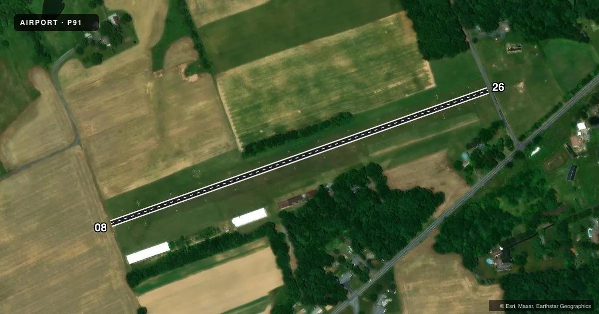
Runways & pattern
Full pagePattern entry · RWY 26
LEFT TRAFFICRunway end performance
| End | TORA | TODA | ASDA | LDA | VGSI | Approach lights | Obstruction |
|---|---|---|---|---|---|---|---|
| 08 | — | — | — | — | — | — | 63', tree, 1223' from thr, 213' R of cntrln, slope 19 |
| 26 | — | — | — | — | — | — | 15', road, 5' from thr, 50' R of cntrln, slope 0 |
Declared distances in feet. TORA = takeoff run available, TODA = takeoff distance, ASDA = accelerate-stop, LDA = landing distance.
Airport sketch
Runways drawn to scale from FAA survey coordinates, rendered over satellite imagery. Not for navigation.
Approaches & charts
Services on the field
Fuel grades, oxygen, maintenance, ramp storage and lighting — as declared to the FAA by the airport operator.
Fuel & services
- Fuel
- Not available
- Airframe repair
- Minor
- Power plant repair
- Minor
Ramp & ground
- Transient storage
- Tie-down
- Hangar
- Landing fee
- No fee published
- Wind indicator
- Yes
- Segmented circle
- No
Fuel & FBOs
Cheapest 100LL and Jet A on the field and nearby. Always confirm with the FBO before taxi.
Airport notes
Surface conditions, obstructions, local procedures, lighting outages and other notes published with each FAA cycle.
General notes
- FOR CD CTC ALLENTOWN APCH AT 800-728-6322.
Approach & departure obstructions
- 26DTHR MKD WITH WHITE CONES.
- 08RWY 08 /26 MKD WITH WHITE CONES.
- 26APCH SLP 20:1 TO DTHR. ALSO 73 FT TREE; 747 FT FM RWY END, 12 FT LEFT OF CNTRLN, 14:1 TO DTHR.
VFR map & nearby airports
VFR sectional. Tap any ICAO chip to open that airport.
Key facts · P91
Answer card- ICAO
- P91
- Name
- FLYING M AERODROME
- Location
- GERMANSVILLE, PENNSYLVANIA
- Elevation
- 735 ft MSL
- Traffic pattern altitude
- 1,735 ft MSL (1,000 AGL)
- Control tower
- Non-towered (use CTAF)
- Total runways
- 1
- Longest runway
- 08/26 · 2,380 ft
- Published ILS approaches
- 0
- Published frequencies
- 2
- Magnetic variation
- 11°
- Current flight rules
- VFR
- Current wind
- 250° at 6 kt
- Favored runway now
- RWY 26
Flying M Aerodrome is in Germansville, Pennsylvania. The field elevation is 735 ft MSL. It has one runway. Runway 08/26 is 2,380 ft long and turf. The airport is non-towered. CTAF and UNICOM are both 122.725. No ILS approaches are published.
Pattern altitude is not published. For light piston traffic, use the standard 1,000 ft AGL pattern unless the current Chart Supplement says otherwise. That puts the pattern at about 1,735 ft MSL based on the field elevation, but verify before you go. Published remarks call out a displaced threshold on runway 26. The approach slope to that threshold is steep. There is also a 73-foot tree near the runway end, left of centerline. Runway 08/26 is marked with white cones.
This is a turf strip with a short runway, so plan for soft-field technique and performance margin. If you need clearance delivery, contact Allentown Approach at 800-728-6322. There are no on-field FBOs listed, so verify services with the airport operator before arrival.