METAR & TAF 14N
14N does not publish a METAR.
Showing the nearest reporting station: KABE (LEHIGH VALLEY INTL) · 14.5 NM away. Conditions at 14N may differ.
METAR · KABE
Observed 05:51Z
KABE 270551Z 19003KT 10SM FEW047 FEW080 BKN110 22/19 A2984 RMK AO2 RAB13E48 SLP102 P0015 60015 T02170194 10272 20211 58006 $
- Wind
- 190° @ 3 kt
- Visibility
- 10 SM
- Temp / Dew
- 22°C / 19°C
- Altimeter
- 29.84 inHg
- Clouds
- BKN
- Density alt
- 2,054 ft
- Ceiling
- 11,000 ft AGL
- Rules
- VFR
Airport info & contacts
Manager on record, flight service, ARTCC, attendance schedule and pattern altitude — published by the FAA and refreshed every 28 days.
Location
- From city
- 3 NM E
- VFR sectional
- NEW YORK
- ARTCC
- ZNY · NEW YORK
- NOTAM facility
- IPT (NOTAM-D)
Airport manager
- Name
- RICHARD D. BELTZ
- Phone
- 610-377-1996
- Address
- 357 AIRPORT ROAD, LEHIGHTON PA 18235
Flight service · Hours
- FSS IPT
- WILLIAMSPORT1-800-WX-BRIEF
- Attendance
- IREG
Frequencies
Tap any row to copy the frequency to your clipboard.
Runways & pattern
Full pagePattern entry · RWY 26
LEFT TRAFFICRunway end performance
| End | TORA | TODA | ASDA | LDA | VGSI | Approach lights | Obstruction |
|---|---|---|---|---|---|---|---|
| 08 | — | — | — | — | — | — | 16', road, 24' from thr, 0' R of cntrln, slope 1 |
| 26 | — | — | — | — | — | — | 13', fence, 48' from thr, 76' R of cntrln, slope 3 |
Declared distances in feet. TORA = takeoff run available, TODA = takeoff distance, ASDA = accelerate-stop, LDA = landing distance.
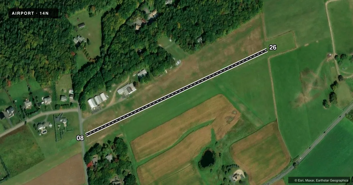
Airport sketch
Runways drawn to scale from FAA survey coordinates, rendered over satellite imagery. Not for navigation.
Approaches & charts
Services on the field
Fuel grades, oxygen, maintenance, ramp storage and lighting — as declared to the FAA by the airport operator.
Fuel & services
- Fuel
- Not available
- Airframe repair
- Minor
- Power plant repair
- Minor
- Other services
- GLD,INSTR,TOW
Ramp & ground
- Transient storage
- Tie-down
- Hangar
- Landing fee
- No fee published
- Customs
- Not available
- Wind indicator
- Yes
- Segmented circle
- No
Fuel & FBOs
Cheapest 100LL and Jet A on the field and nearby. Always confirm with the FBO before taxi.
Airport notes
Surface conditions, obstructions, local procedures, lighting outages and other notes published with each FAA cycle.
General notes
- RWY NOT PLOWED DURING WINTER.
- ULTRALIGHT TFC, DEER & GEESE ON & INVOF ARPT.
- EXPC LGT TO MOD TURB WITH N WINDS 10-15 KTS; OPS NOT RCMDD OVER 15 KTS.
- FOR CD CTC ALLENTOWN APCH AT 800-728-6322.
Runway surface & condition
- 08/26THRS MKD WITH WHITE MKRS. EDGE MKRS ALG SE EDGE ONLY.
Approach & departure obstructions
- 26107 FT TREES, 935 FT FROM RWY END 115 FT RIGHT; 11:1 SLP TO DTHR.
- 08APCH RATIO 20:1 TO DTHR.
- 26APCH RATIO 11:1 TO DTHR.
Other notes
- EXISTED PRIOR TO 1959.
- ANNOUNCE TFC ON CTAF.
- 1FOR SVC CTC (610) 377-1996.
VFR map & nearby airports
VFR sectional. Tap any ICAO chip to open that airport.
Key facts · 14N
Answer card- ICAO
- 14N
- Name
- BELTZVILLE
- Location
- LEHIGHTON, PENNSYLVANIA
- Elevation
- 899 ft MSL
- Traffic pattern altitude
- 1,899 ft MSL (1,000 AGL)
- Control tower
- Non-towered (use CTAF)
- Total runways
- 1
- Longest runway
- 08/26 · 2,018 ft
- Published ILS approaches
- 0
- Published frequencies
- 1
- Magnetic variation
- 11°
- Current flight rules
- VFR
- Current wind
- 190° at 3 kt
- Favored runway now
- RWY 26
Beltzville (14N) sits near Lehighton, Pennsylvania. Field elevation is 899 ft MSL. The airport has one runway. Runway 08/26 is 2,018 ft of turf, so plan for short-field performance and soft-field technique. There is no control tower. CTAF is 122.9. No ILS approaches are published here.
The pattern altitude is not published. Use the standard 1,000 ft AGL unless the current Chart Supplement says otherwise. The published remarks matter here. Expect light to moderate turbulence with north winds from 10 to 15 knots. Operations are not recommended over 15 knots. The runway is not plowed in winter. Deer, geese and ultralight traffic are reported in the area. Thresholds are marked with white markers. Edge markers are only along the southeast edge.
There are no on-field FBOs listed. Contact the airport operator directly before arrival, or call the field on CTAF for current service details. For clearance delivery, the published contact is Allentown Approach. The field also has displaced threshold obstacle notes on both ends. A careful look at runway length, slope and departure path is smart before you go.