METAR & TAF 22N
Current METAR
Observed 11:35Z
K22N 271135Z AUTO 00000KT 10SM CLR 17/17 A2987 RMK AO2
- Wind
- 000° @ 0 kt
- Visibility
- 10 SM
- Temp / Dew
- 17°C / 17°C
- Altimeter
- 29.87 inHg
- Clouds
- CLR
- Density alt
- 964 ft
- Ceiling
- Unlimited
- Rules
- VFR
Airport info & contacts
Manager on record, flight service, ARTCC, attendance schedule and pattern altitude — published by the FAA and refreshed every 28 days.
Location
- From city
- 3 NM SW
- VFR sectional
- NEW YORK
- ARTCC
- ZNY · NEW YORK
- NOTAM facility
- IPT (NOTAM-D)
Airport manager
- Name
- PAUL SMITH
- Phone
- 570-778-4783
- Address
- 2321 MAHONING DRIVE EAST, LEHIGHTON PA 18235
Flight service · Hours
- FSS IPT
- WILLIAMSPORT1-800-WX-BRIEF
- Attendance
- 0800-DUSK
Frequencies
Tap any row to copy the frequency to your clipboard.
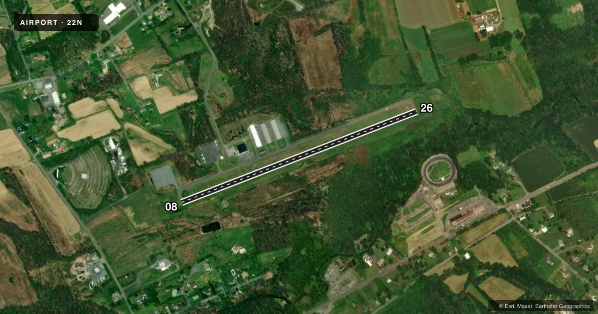
Runways & pattern
Full pagePattern entry · RWY 08
LEFT TRAFFICRunway end performance
| End | TORA | TODA | ASDA | LDA | VGSI | Approach lights | Obstruction |
|---|---|---|---|---|---|---|---|
| 08 | — | — | — | — | PAPI 2-box left(3°) | — | 48', tree, 763' from thr, 298' R of cntrln, slope 11 |
| 26 | — | — | — | — | PAPI 2-box left(3°) | — | 76', trees, 441' from thr, 267' R of cntrln, slope 3 |
Declared distances in feet. TORA = takeoff run available, TODA = takeoff distance, ASDA = accelerate-stop, LDA = landing distance.
Airport sketch
Runways drawn to scale from FAA survey coordinates, rendered over satellite imagery. Not for navigation.
Approaches & charts
Services on the field
Fuel grades, oxygen, maintenance, ramp storage and lighting — as declared to the FAA by the airport operator.
Fuel & services
- Fuel
- 100LLA
- Oxygen (bottled)
- Not available
- Oxygen (bulk)
- Not available
- Airframe repair
- Major
- Power plant repair
- Major
- Other services
- CHTR,INSTR,RNTL
Ramp & ground
- Transient storage
- Tie-down
- Hangar
- Landing fee
- No fee published
- Customs
- Not available
- Lighting schedule
- SEE RMK
- Beacon schedule
- SS-SR
- Beacon
- White / Green (civil land)(WG)
- Wind indicator
- Lighted
- Segmented circle
- Yes
Fuel & FBOs
Cheapest 100LL and Jet A on the field and nearby. Always confirm with the FBO before taxi.
Airport notes
Surface conditions, obstructions, local procedures, lighting outages and other notes published with each FAA cycle.
General notes
- DEER AND GEESE ON AND IN VICINITY OF ARPT.
- 24 HR SELF SERVE 100LL AND JET A
- FOR CD CTC ALLENTOWN APCH AT 800-728-6322.
- COLD TEMPERATURE AIRPORT. ALTITUDE CORRECTION REQUIRED AT OR BELOW -22C.
Lighting notes
- ACTVT REIL RWY 08 & 26; PAPI RWY 08 & 26; MIRL RWY 08/26 - CTAF.
Approach & departure obstructions
- 0811 FT BRUSH, 163 FT FM RWY END, 90 FT R.
Other notes
- THIS AIRPORT HAS BEEN SURVEYED BY THE NATIONAL GEODETIC SURVEY.
- NO OJECTION.
- MANAGERFOR ASST AFTER HRS CTC 570-778-4783.
VFR map & nearby airports
VFR sectional. Tap any ICAO chip to open that airport.
Key facts · 22N
Answer card- ICAO
- 22N
- Name
- JAKE ARNER MEML
- Location
- LEHIGHTON, PENNSYLVANIA
- Elevation
- 534 ft MSL
- Traffic pattern altitude
- 1,534 ft MSL (1,000 AGL)
- Control tower
- Non-towered (use CTAF)
- Total runways
- 1
- Longest runway
- 08/26 · 3,000 ft
- Published ILS approaches
- 0
- Published frequencies
- 5
- Magnetic variation
- 12°
- Current flight rules
- VFR
- Current wind
- 000° at 0 kt
- Favored runway now
- –
Jake Arner Memorial Airport is in Lehighton, Pennsylvania. Field elevation is 534 ft MSL. The airport has one runway, 08/26, which is 3,000 ft long and asphalt. There is no control tower. The published pattern altitude is not listed, so use the standard 1,000 ft AGL pattern unless the current Chart Supplement says otherwise.
No ILS approaches are published here. Runway lighting is pilot-controlled on CTAF 123.05. Runway end identifier lights are installed on 08 and 26. Precision approach path indicators are also installed on both ends. The field has a published brush obstruction near the 08 end. It sits 163 ft from the runway end and 90 ft right of centerline. Deer and geese are also reported on and near the airport.
Jake Arner Memorial Airport is a cold temperature airport. Altitude correction is required at or below minus 22 degrees Celsius. For clearance delivery, contact Allentown Approach at 800-728-6322. On the field, Jake Arner Memorial Airport carries 100LL and Jet A. Twenty-four hour self-serve fuel is published. For after-hours help, contact the manager at 570-778-4783. Pilots should also check current airspace and arrival procedures before going in, since the airport uses Allentown approach frequencies for IFR services.