METAR & TAF KXLL
Current METAR
Observed 11:55Z
KXLL 271155Z AUTO 00000KT 10SM CLR 21/17 A2987 RMK AO2 TSNO
- Wind
- 000° @ 0 kt
- Visibility
- 10 SM
- Temp / Dew
- 21°C / 17°C
- Altimeter
- 29.87 inHg
- Clouds
- CLR
- Density alt
- 1,277 ft
- Ceiling
- Unlimited
- Rules
- VFR
Airport info & contacts
Manager on record, flight service, ARTCC, attendance schedule and pattern altitude — published by the FAA and refreshed every 28 days.
Location
- From city
- 2 NM SW
- VFR sectional
- NEW YORK
- ARTCC
- ZNY · NEW YORK
- NOTAM facility
- IPT (NOTAM-D)
Airport manager
- Name
- THOMAS R STOUDT
- Phone
- 610-791-5193
- Address
- 1730 VULTEE ST, ALLENTOWN PA 18109
Flight service · Hours
- FSS IPT
- WILLIAMSPORT1-800-WX-BRIEF
- Attendance
- 0700-1900
Frequencies
Tap any row to copy the frequency to your clipboard.
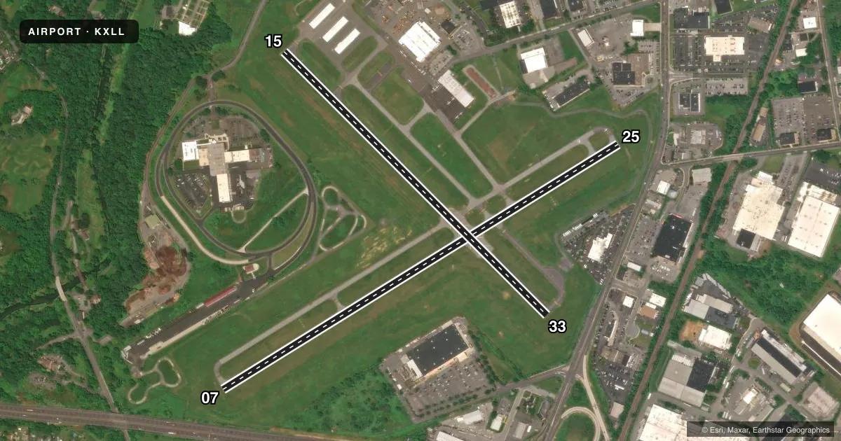
Runways & pattern
Full pagePattern entry · RWY 07
LEFT TRAFFIC| Runway | Heading (°M) | Length | Surface | Traffic |
|---|---|---|---|---|
| 07/25 | 46° / 226° | 3,950 ft | ASPH | Standard L |
| 15/33 | 123° / 303° | 3,160 ft | ASPH | Standard L |
Runway end performance
| End | TORA | TODA | ASDA | LDA | VGSI | Approach lights | Obstruction |
|---|---|---|---|---|---|---|---|
| 07 | — | — | — | — | PAPI 4-box left(3°) | — | 16', brush, 354' from thr, 95' R of cntrln, slope 9 |
| 25 | — | — | — | — | PAPI 4-box left(3.5°) | — | 23', pole, 635' from thr, 112' R of cntrln, slope 19 |
Declared distances in feet. TORA = takeoff run available, TODA = takeoff distance, ASDA = accelerate-stop, LDA = landing distance.
Airport sketch
Runways drawn to scale from FAA survey coordinates, rendered over satellite imagery. Not for navigation.
Approaches & charts
Services on the field
Fuel grades, oxygen, maintenance, ramp storage and lighting — as declared to the FAA by the airport operator.
Fuel & services
- Fuel
- 100LLA
- Oxygen (bulk)
- Not available
- Airframe repair
- Major
- Power plant repair
- Major
- Other services
- AFRT,INSTR,RNTL
Ramp & ground
- Transient storage
- Tie-down
- Hangar
- Landing fee
- No fee published
- Customs
- Not available
- Lighting schedule
- SEE RMK
- Beacon schedule
- SS-SR
- Beacon
- White / Green (civil land)(WG)
- Wind indicator
- Lighted
- Segmented circle
- No
Fuel & FBOs
Cheapest 100LL and Jet A on the field and nearby. Always confirm with the FBO before taxi.
Airport notes
Surface conditions, obstructions, local procedures, lighting outages and other notes published with each FAA cycle.
General notes
- DEER, GROUNDHOGS & BIRDS ON & INVOF ARPT.
- NOISE ABATEMENT PROC IN EFCT, FOR DETAILS CTC AMGR.
- FOR SVC AFT HRS CTC 610-266-6000.
- FOR CD CTC ALLENTOWN APCH AT 800-728-6322.
Lighting notes
- ACTVT REIL RWY 07/25; MIRL RWY 07/25 & 15/33 - CTAF.
Approach & departure obstructions
- 074FT SHRUB, 154 FT FM RWY END, 177 FT R.
- 25UNUSBL BYD 3 DEG L OF CRS.
Other notes
- EXISTED PRIOR TO 1959.
VFR map & nearby airports
VFR sectional. Tap any ICAO chip to open that airport.
Key facts · KXLL
Answer card- ICAO
- KXLL
- Name
- ALLENTOWN QUEEN CITY MUNI
- Location
- ALLENTOWN, PENNSYLVANIA
- Elevation
- 399 ft MSL
- Traffic pattern altitude
- 1,399 ft MSL (1,000 AGL)
- Control tower
- Non-towered (use CTAF)
- Total runways
- 2
- Longest runway
- 07/25 · 3,950 ft
- Published ILS approaches
- 0
- Published frequencies
- 6
- Magnetic variation
- 12°
- Current flight rules
- VFR
- Current wind
- 000° at 0 kt
- Favored runway now
- –
Allentown Queen City Muni is in Allentown, Pennsylvania. Field elevation is 399 ft MSL. The airport has two asphalt runways. The longest is runway 07/25 at 3,950 ft. There is no control tower. No ILS approaches are published.
Pattern altitude is not published. Use the standard 1,000 ft AGL pattern unless local procedures or the current Chart Supplement say otherwise. The field sits in a busy part of eastern Pennsylvania. Expect to work with Allentown Approach for clearances and sequencing. Published remarks also call out noise abatement procedures. Check with the airport manager for current details before you go.
Lehigh Valley Aviation Services is on the field. It carries 100LL, Jet A and Jet A Prist. If you need service after hours, the published contact number is 610-266-6000. Runway 07/25 has activated REILs. Medium intensity runway lights are on both runways and are controlled by CTAF. Be aware of wildlife on and near the airport. The published remarks also note a small shrub near the departure end of runway 07. Runway 25 has a published course limitation beyond 3 degrees left of course. For clearance delivery, contact Allentown Approach at 800-728-6322.