METAR & TAF KUKT
Current METAR
Observed 05:35Z
KUKT 270535Z AUTO 00000KT 10SM SCT060 SCT075 20/18 A2986 RMK AO2
- Wind
- 000° @ 0 kt
- Visibility
- 10 SM
- Temp / Dew
- 20°C / 18°C
- Altimeter
- 29.86 inHg
- Clouds
- SCT
- Density alt
- 1,326 ft
- Ceiling
- Unlimited
- Rules
- VFR
Airport info & contacts
Manager on record, flight service, ARTCC, attendance schedule and pattern altitude — published by the FAA and refreshed every 28 days.
Location
- From city
- 2 NM W
- VFR sectional
- NEW YORK
- ARTCC
- ZNY · NEW YORK
- NOTAM facility
- UKT (NOTAM-D)
Airport manager
- Name
- PHIL REINFORD
- Phone
- 215-720-9715
- Address
- 2425 MILFORD SQUARE PIKE, QUAKERTOWN PA 18951
Flight service · Hours
- FSS IPT
- WILLIAMSPORT1-800-WX-BRIEF
- Attendance
- 0830-1700
Frequencies
Tap any row to copy the frequency to your clipboard.
Runways & pattern
Full pagePattern entry · RWY 11
LEFT TRAFFICRunway end performance
| End | TORA | TODA | ASDA | LDA | VGSI | Approach lights | Obstruction |
|---|---|---|---|---|---|---|---|
| 11 | 3,210' | 3,210' | — | — | PAPI 2-box left(4°) | — | 77', trees, 613' from thr, 275' R of cntrln, slope 5 |
| 29 | 3,210' | 3,210' | — | — | PAPI 2-box left(4°) | — | 27', tree, 213' from thr, 166' R of cntrln, slope 0 |
Declared distances in feet. TORA = takeoff run available, TODA = takeoff distance, ASDA = accelerate-stop, LDA = landing distance.
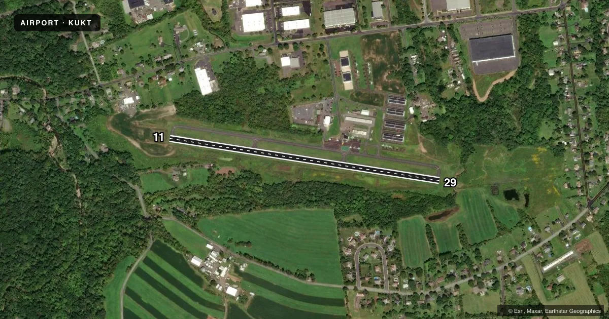
Airport sketch
Runways drawn to scale from FAA survey coordinates, rendered over satellite imagery. Not for navigation.
Approaches & charts
Services on the field
Fuel grades, oxygen, maintenance, ramp storage and lighting — as declared to the FAA by the airport operator.
Fuel & services
- Fuel
- 100LL
- Oxygen (bottled)
- Not available
- Oxygen (bulk)
- Not available
- Airframe repair
- Major
- Power plant repair
- Major
- Other services
- INSTR,RNTL
Ramp & ground
- Transient storage
- Tie-down
- Landing fee
- No fee published
- Customs
- Not available
- Lighting schedule
- SEE RMK
- Beacon schedule
- SS-SR
- Beacon
- White / Green (civil land)(WG)
- Wind indicator
- Lighted
- Segmented circle
- No
Fuel & FBOs
Cheapest 100LL and Jet A on the field and nearby. Always confirm with the FBO before taxi.
Airport notes
Surface conditions, obstructions, local procedures, lighting outages and other notes published with each FAA cycle.
General notes
- DEER ON & INVOF ARPT.
- ACFT WITH WING SPAN GREATER THAN 54.5 FEET MUST COORDINATE WITH AMGR.
- FOR CD CTC PHILADELPHIA APCH AT 800-354-9884.
Lighting notes
- DUSK-DAWN. ACTVT REIL RWY 11 & 29; MIRL 11/29 - CTAF.
Fuel notes
- 100LL100 LL AVBL 24 HRS SELF-SERVE CREDIT CARD.
Approach & departure obstructions
- 29APCH SLP 15:1 TO 190 FT DTHR.
VFR map & nearby airports
VFR sectional. Tap any ICAO chip to open that airport.
Key facts · KUKT
Answer card- ICAO
- KUKT
- Name
- QUAKERTOWN
- Location
- QUAKERTOWN, PENNSYLVANIA
- Elevation
- 525.1 ft MSL
- Traffic pattern altitude
- 1,525.1 ft MSL (1,000 AGL)
- Control tower
- Non-towered (use CTAF)
- Total runways
- 1
- Longest runway
- 11/29 · 3,210 ft
- Published ILS approaches
- 0
- Published frequencies
- 5
- Magnetic variation
- 12°
- Current flight rules
- VFR
- Current wind
- 000° at 0 kt
- Favored runway now
- –
Quakertown Airport is in Quakertown, Pennsylvania. The field elevation is 525.1 ft MSL. It has one runway, 11/29, which is 3,210 ft long on asphalt. There is no control tower. CTAF and UNICOM are both 122.725.
No ILS approaches are published here. Pattern altitude is not published, so use the standard 1,000 ft AGL for light piston traffic unless the current Chart Supplement says otherwise. The airport sits in a busy part of eastern Pennsylvania, so expect to stay sharp on radio work and traffic scanning. Deer are reported on and near the field. Runway 29 also has a published displaced threshold note, so brief that before arrival.
Heartwood Aviation is on the field. It carries 100LL. 100LL is also available 24 hours through self-service credit card. For clearance delivery, Philadelphia Approach is the published contact. Aircraft with a wingspan greater than 54.5 ft must coordinate with the airport manager. Runway end identifier lights are available from dusk to dawn on both runway ends. Medium intensity runway lights are pilot-controlled on the CTAF.