METAR & TAF KPTW
Current METAR
Observed 05:54Z
KPTW 270554Z AUTO 00000KT 10SM FEW080 21/18 A2986 RMK AO2 SLP108 T02060178 10261 20206 58006
- Wind
- 000° @ 0 kt
- Visibility
- 10 SM
- Temp / Dew
- 21°C / 18°C
- Altimeter
- 29.86 inHg
- Clouds
- FEW
- Density alt
- 1,177 ft
- Ceiling
- Unlimited
- Rules
- VFR
Airport info & contacts
Manager on record, flight service, ARTCC, attendance schedule and pattern altitude — published by the FAA and refreshed every 28 days.
Location
- From city
- 3 NM E
- VFR sectional
- NEW YORK
- ARTCC
- ZNY · NEW YORK
- NOTAM facility
- PTW (NOTAM-D)
Airport manager
- Name
- JEFF HEACOCK
- Phone
- (610) 495-7000
- Address
- 3310 WEST RIDGE PIKE, POTTSTOWN PA 19464
Flight service · Hours
- FSS IPT
- WILLIAMSPORT1-800-WX-BRIEF
- Attendance
- MON-FRI · 0700-2000
- SAT-SUN · 0700-1800
Frequencies
Tap any row to copy the frequency to your clipboard.
Runways & pattern
Full pagePattern entry · RWY 10
LEFT TRAFFICRunway end performance
| End | TORA | TODA | ASDA | LDA | VGSI | Approach lights | Obstruction |
|---|---|---|---|---|---|---|---|
| 10 | — | — | — | — | PAPI 2-box left(3°) | — | 14', trees, 381' from thr, 13' R of cntrln, slope 12 |
| 28 | — | — | — | — | PAPI 2-box left(3°) | — | 40', trees, 576' from thr, 269' R of cntrln, slope 9 |
Declared distances in feet. TORA = takeoff run available, TODA = takeoff distance, ASDA = accelerate-stop, LDA = landing distance.
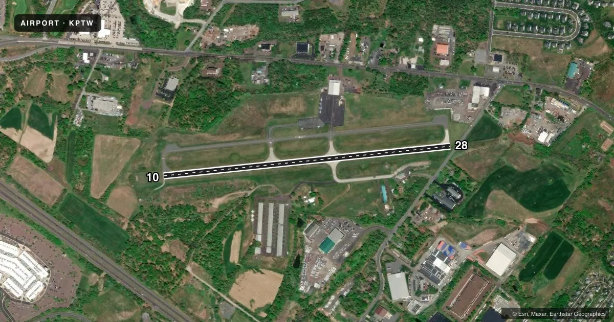
Airport sketch
Runways drawn to scale from FAA survey coordinates, rendered over satellite imagery. Not for navigation.
Approaches & charts
ILS · 1
Services on the field
Fuel grades, oxygen, maintenance, ramp storage and lighting — as declared to the FAA by the airport operator.
Fuel & services
- Fuel
- 100LLA
- Oxygen (bottled)
- Not available
- Oxygen (bulk)
- Not available
- Airframe repair
- Major
- Power plant repair
- Major
- Other services
- AFRT,CHTR,INSTR
Ramp & ground
- Transient storage
- Tie-down
- Hangar
- Landing fee
- Yes
- Customs
- Not available
- Lighting schedule
- SEE RMK
- Beacon schedule
- SEE RMK
- Beacon
- White / Green (civil land)(WG)
- Wind indicator
- Lighted
- Segmented circle
- Yes
Fuel & FBOs
Cheapest 100LL and Jet A on the field and nearby. Always confirm with the FBO before taxi.
Airport notes
Surface conditions, obstructions, local procedures, lighting outages and other notes published with each FAA cycle.
General notes
- LGTD & MKD 507 FT AGL (769 FT MSL) STACK 6000 FT W OF RWY 10.
- BIRDS & DEER ON & INVOF ARPT.
- FOR CD CTC PHILADELPHIA APCH AT 800-354-9884.
Lighting notes
- ACTVT ROTG BCN - 122.7.
- ACTVT MIRL RWY 10/28 - 122.7.
Approach & departure obstructions
- 2810 FT ROAD 0-200 FT FM THR.
- 28RWY 28 APCH RATIO 19:1 TO DTHR.
Other notes
- EXISTED PRIOR TO 1959.
VFR map & nearby airports
VFR sectional. Tap any ICAO chip to open that airport.
Key facts · KPTW
Answer card- ICAO
- KPTW
- Name
- HERITAGE FLD
- Location
- POTTSTOWN, PENNSYLVANIA
- Elevation
- 308.2 ft MSL
- Traffic pattern altitude
- 1,308.2 ft MSL (1,000 AGL)
- Control tower
- Non-towered (use CTAF)
- Total runways
- 1
- Longest runway
- 10/28 · 3,371 ft
- Published ILS approaches
- 1
- Published frequencies
- 5
- Magnetic variation
- 12°
- Current flight rules
- VFR
- Current wind
- 000° at 0 kt
- Favored runway now
- –
Heritage Fld is in Pottstown, Pennsylvania. The field elevation is 308.2 ft MSL. It has one runway. The longest runway is 10/28 at 3,371 ft. There is no control tower. Philadelphia Approach handles clearance delivery and approach services. The airport has one ILS approach. Runway 28 is the published end.
Pattern altitude is not published. Use 1,000 ft AGL for light piston traffic unless the current FAA Chart Supplement or local procedures say otherwise. Pitcairn Aviation is on the field. It carries 100LL and Jet A. Medium intensity runway lights on 10/28 are activated on CTAF 122.7. The rotating beacon is also activated on 122.7.
For a first-time arrival, pay attention to the published obstructions near runway 28. There is a 10-foot road close to the threshold area. The displaced threshold on 28 also has a 21:1 approach ratio noted in the remarks. Birds and deer are reported on and near the airport. There is also a lighted and marked stack about 6,000 feet west of runway 10. Check the current FAA Chart Supplement for any updated local procedures before you go.