METAR & TAF KOQN
Current METAR
Observed 12:35Z
KOQN 271235Z AUTO 25004KT 10SM CLR 21/18 A2988 RMK AO2
- Wind
- 250° @ 4 kt
- Visibility
- 10 SM
- Temp / Dew
- 21°C / 18°C
- Altimeter
- 29.88 inHg
- Clouds
- CLR
- Density alt
- 1,346 ft
- Ceiling
- Unlimited
- Rules
- VFR
Airport info & contacts
Manager on record, flight service, ARTCC, attendance schedule and pattern altitude — published by the FAA and refreshed every 28 days.
Location
- From city
- 3 NM NE
- VFR sectional
- WASHINGTON
- ARTCC
- ZNY · NEW YORK
- NOTAM facility
- IPT (NOTAM-D)
Airport manager
- Name
- JOHN KASSAB
- Phone
- 610-692-6100
- Address
- 1205 WARD AVE, WEST CHESTER PA 19380
Flight service · Hours
- FSS IPT
- WILLIAMSPORT1-800-WX-BRIEF
- Attendance
- 0800-1700
Frequencies
Tap any row to copy the frequency to your clipboard.
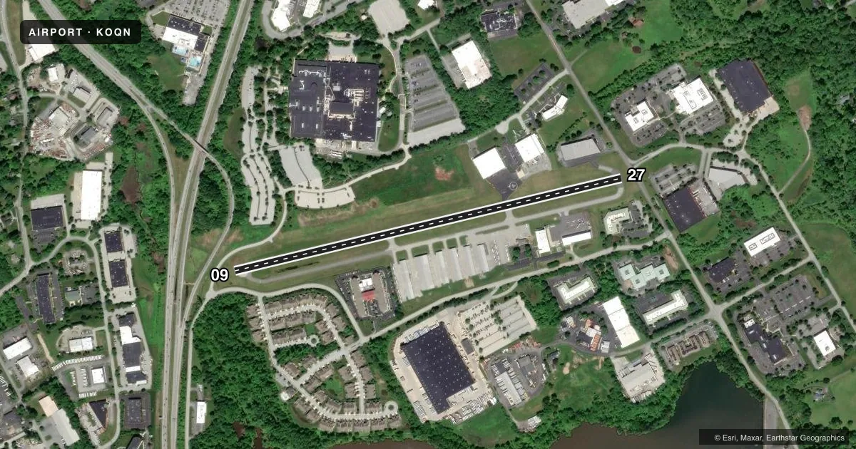
Runways & pattern
Full pagePattern entry · RWY 27
LEFT TRAFFICRunway end performance
| End | TORA | TODA | ASDA | LDA | VGSI | Approach lights | Obstruction |
|---|---|---|---|---|---|---|---|
| 09 | — | — | — | — | PAPI 2-box left(4.2°) | — | — |
| 27 | — | — | — | — | PAPI 2-box left(3°) | — | — |
Declared distances in feet. TORA = takeoff run available, TODA = takeoff distance, ASDA = accelerate-stop, LDA = landing distance.
Airport sketch
Runways drawn to scale from FAA survey coordinates, rendered over satellite imagery. Not for navigation.
Approaches & charts
Services on the field
Fuel grades, oxygen, maintenance, ramp storage and lighting — as declared to the FAA by the airport operator.
Fuel & services
- Fuel
- 100LLA
- Oxygen (bottled)
- Not available
- Oxygen (bulk)
- Not available
- Airframe repair
- Major
- Power plant repair
- Major
- Other services
- AMB,CHTR,INSTR,RNTL
Ramp & ground
- Transient storage
- Tie-down
- Landing fee
- Yes
- Customs
- Not available
- Lighting schedule
- SS-SR
- Beacon schedule
- SS-SR
- Beacon
- White / Green (civil land)(WG)
- Wind indicator
- Lighted
- Segmented circle
- No
Fuel & FBOs
Cheapest 100LL and Jet A on the field and nearby. Always confirm with the FBO before taxi.
Airport notes
Surface conditions, obstructions, local procedures, lighting outages and other notes published with each FAA cycle.
General notes
- TFC DEP RWY 27 CLIMB OUT STRAIGHT AHD TIL RCHG 1300 FT MSL; THEN TURN ON CRS FOR NOISE ABATEMENT.
- BIRDS & DEER ON & INVOF ARPT.
- FOR SVC AFT HRS CTC 610-842-3804.
- FULL LENGTH PARALLEL TWY S OF RWY.
- FOR CD CTC PHILADELPHIA APCH AT 800-354-9884.
Approach & departure obstructions
- 27ROAD TRAVERSING THE 200 FT PRIMARY SFC AREA BYD EOR; ROAD RISES TO +13 FT AT A POINT 14 FT FROM EOR 265 FT R.
- 27CALM WIND RWY.
- 09PAPI OPS CONS.
- 27PAPI OPS CONS.
Other notes
- RAMP FEE OR FUEL.
VFR map & nearby airports
VFR sectional. Tap any ICAO chip to open that airport.
Key facts · KOQN
Answer card- ICAO
- KOQN
- Name
- BRANDYWINE RGNL
- Location
- WEST CHESTER, PENNSYLVANIA
- Elevation
- 464.6 ft MSL
- Traffic pattern altitude
- 1,464.6 ft MSL (1,000 AGL)
- Control tower
- Non-towered (use CTAF)
- Total runways
- 1
- Longest runway
- 09/27 · 3,347 ft
- Published ILS approaches
- 0
- Published frequencies
- 5
- Magnetic variation
- 12°
- Current flight rules
- VFR
- Current wind
- 250° at 4 kt
- Favored runway now
- RWY 27
Brandywine Rgnl sits in West Chester, Pennsylvania. The field elevation is 464.6 ft MSL. It has one runway, 09/27, which is 3,347 ft long. There is no control tower. No ILS approaches are published here. Pattern altitude is not published, so use 1,000 ft AGL for light piston traffic unless the current Chart Supplement says otherwise.
New Brandywine Aero is on the field. It carries 100LL and Jet A Prist. The remarks also note a ramp fee or fuel charge, so plan on checking with the FBO before you arrive. After-hours service is available by phone. Runway 27 is listed as the calm wind runway. The PAPI is operational on both runway ends.
This is a busy local airport with Philadelphia Approach handling clearance delivery and approach or departure services. The runway has a full-length parallel taxiway south of it. There is also a published caution about birds and deer in the area. Runway 27 has an obstacle note beyond the departure end, so pay attention to the departure path and stay alert on rollout. If you are flying in for the first time, brief the noise abatement on runway 27. Depart straight ahead to 1,300 ft MSL before turning on course.