METAR & TAF KEVY
KEVY does not publish a METAR.
Showing the nearest reporting station: KILG (NEW CASTLE) · 10.9 NM away. Conditions at KEVY may differ.
METAR · KILG
Observed 12:51Z
KILG 271251Z 25004KT 10SM CLR 23/20 A2986 RMK AO2 SLP112 T02330200 PNO $
- Wind
- 250° @ 4 kt
- Visibility
- 10 SM
- Temp / Dew
- 23°C / 20°C
- Altimeter
- 29.86 inHg
- Clouds
- CLR
- Density alt
- 1,121 ft
- Ceiling
- Unlimited
- Rules
- VFR
Airport info & contacts
Manager on record, flight service, ARTCC, attendance schedule and pattern altitude — published by the FAA and refreshed every 28 days.
Location
- From city
- 5 NM N
- VFR sectional
- WASHINGTON
- ARTCC
- ZNY · NEW YORK
- NOTAM facility
- MIV (NOTAM-D)
Airport manager
- Name
- RALPH KUNZ
- Phone
- 302-834-5400
- Address
- 4200 SUMMIT BRIDGE ROAD, MIDDLETOWN DE 19709
Flight service · Hours
- FSS MIV
- MILLVILLE1-800-WX-BRIEF
- Attendance
- 0700-1900
Frequencies
Tap any row to copy the frequency to your clipboard.
Runways & pattern
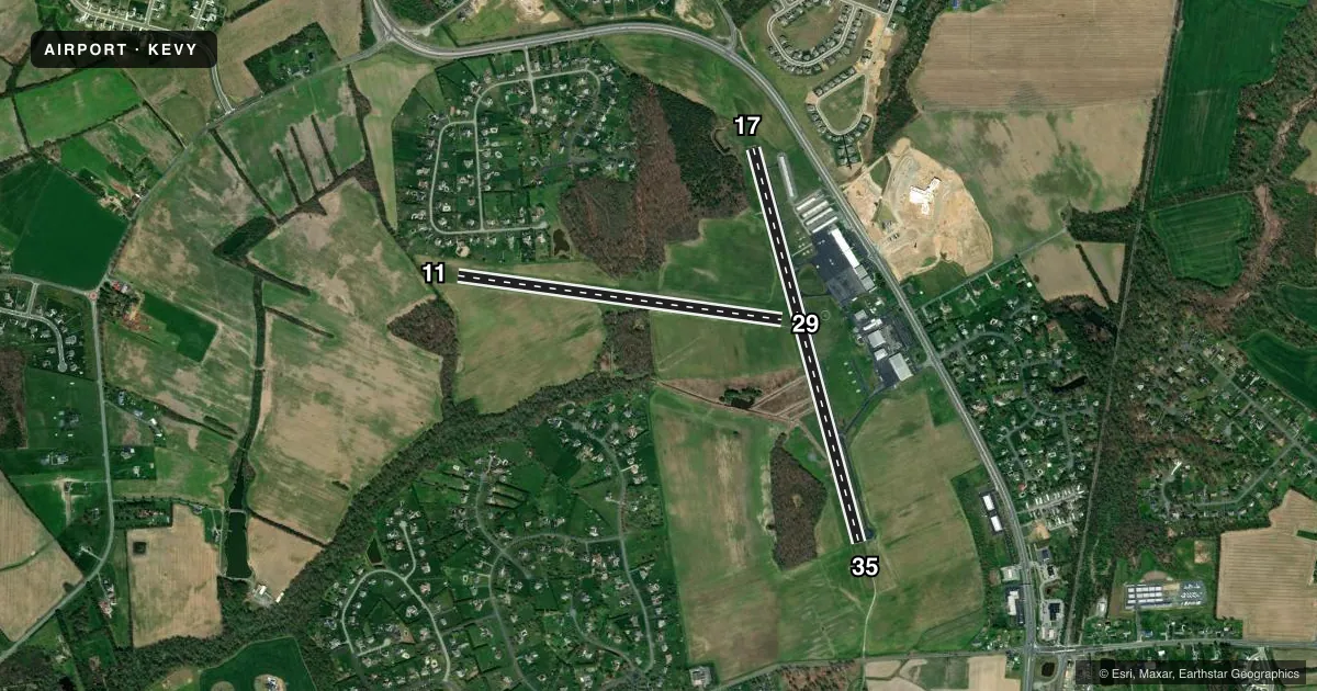
Full pagePattern entry · RWY 29
LEFT TRAFFIC| Runway | Heading (°M) | Length | Surface | Traffic |
|---|---|---|---|---|
| 17/35 | 155° / 335° | 4,488 ft | ASPH | Standard L |
| 11/29Favored | 88° / 268° | 3,601 ft | TURF | Standard L |
Runway end performance
| End | TORA | TODA | ASDA | LDA | VGSI | Approach lights | Obstruction |
|---|---|---|---|---|---|---|---|
| 17 | — | — | — | — | PAPI 4-box right(3°) | — | 70', trees, 1250' from thr, 0' R of cntrln, slope 15 |
| 35 | — | — | — | — | PAPI 4-box left(3°) | — | — |
| 11 | — | — | — | — | — | — | 42', tree, 420' from thr, 70' R of cntrln, slope 10 |
Declared distances in feet. TORA = takeoff run available, TODA = takeoff distance, ASDA = accelerate-stop, LDA = landing distance.
Airport sketch
Runways drawn to scale from FAA survey coordinates, rendered over satellite imagery. Not for navigation.
Approaches & charts
Services on the field
Fuel grades, oxygen, maintenance, ramp storage and lighting — as declared to the FAA by the airport operator.
Fuel & services
- Fuel
- 100LLA
- Oxygen (bottled)
- Not available
- Oxygen (bulk)
- Low pressure
- Airframe repair
- Major
- Power plant repair
- Major
- Other services
- AVNCS,INSTR
Ramp & ground
- Transient storage
- Tie-down
- Hangar
- Landing fee
- No fee published
- Customs
- Not available
- Lighting schedule
- SEE RMK
- Beacon schedule
- SS-SR
- Beacon
- White / Green (civil land)(WG)
- Wind indicator
- Lighted
- Segmented circle
- Yes
Fuel & FBOs
Cheapest 100LL and Jet A on the field and nearby. Always confirm with the FBO before taxi.
Airport notes
Surface conditions, obstructions, local procedures, lighting outages and other notes published with each FAA cycle.
General notes
- EXTSV MED/HVY HEL TRNG IN PROG ALL HRS ON & INVOF ARPT; HIGH ROTOR DOWNWASH VELOCITIES. WHEN CH47 HELICOPTERS OPERATING, REQUEST ADVISORIES ON UNICOM.
- FOR CD CTC PHILADELPHIA APCH AT 800-354-9884.
- RWY 11/29 CLSD FOR NIGHT OPS.
Lighting notes
- ACTVT LIRL & REILS RY 11/29 - 123.5.
Runway surface & condition
- 11/29LIRL RY 11/29 OTS INDEFLY.
Approach & departure obstructions
- 11REIL RY 11 & RY 29 OTS INDEFLY.
Other notes
- THIS AIRPORT HAS BEEN SURVEYED BY THE NATIONAL GEODETIC SURVEY.
- EXISTED PRIOR TO 1959
VFR map & nearby airports
VFR sectional. Tap any ICAO chip to open that airport.
Key facts · KEVY
Answer card- ICAO
- KEVY
- Name
- SUMMIT
- Location
- MIDDLETOWN, DELAWARE
- Elevation
- 69.9 ft MSL
- Traffic pattern altitude
- 1,069.9 ft MSL (1,000 AGL)
- Control tower
- Non-towered (use CTAF)
- Total runways
- 2
- Longest runway
- 17/35 · 4,488 ft
- Published ILS approaches
- 0
- Published frequencies
- 4
- Magnetic variation
- 10°
- Current flight rules
- VFR
- Current wind
- 250° at 4 kt
- Favored runway now
- RWY 29
Summit Airport sits near Middletown, Delaware at 69.9 ft MSL. It has two runways. The longest is runway 17/35 at 4,488 ft asphalt. Runway 11/29 is 3,601 ft turf. There is no control tower. CTAF and UNICOM are both 122.725. Philadelphia Approach handles IFR services on 118.35 and 323.1. No ILS approaches are published here.
Pattern altitude is not published. Use the standard 1,000 ft AGL for light piston aircraft unless the current Chart Supplement says otherwise. Summit Aviation is the on-field FBO. It carries 100LL, Jet A and Jet A Prist. Call (302) 449-1052 for current services before arrival.
The big operational item here is helicopter traffic. Published remarks say medium and heavy helicopter training happens at all hours in and around the airport. Expect rotor downwash. When CH47 helicopters are operating, ask for advisories on UNICOM. Runway 11/29 is closed for night operations. Its low intensity lights are out of service indefinitely. The runway end identifier lights for 11 and 29 are also out of service indefinitely. If you need clearance delivery, contact Philadelphia Approach at 800-354-9884. Plan with those items in mind before you launch.