METAR & TAF MD1
MD1 does not publish a METAR.
Showing the nearest reporting station: KDOV (DOVER AFB) · 18.6 NM away. Conditions at MD1 may differ.
METAR · KDOV
Observed 14:55Z
KDOV 271455Z 00000KT 10SM CLR 27/21 A2983 RMK AO2A SLP105 T02660209 50001
- Wind
- 000° @ 0 kt
- Visibility
- 10 SM
- Temp / Dew
- 27°C / 21°C
- Altimeter
- 29.83 inHg
- Clouds
- CLR
- Density alt
- 1,642 ft
- Ceiling
- Unlimited
- Rules
- VFR
Airport info & contacts
Manager on record, flight service, ARTCC, attendance schedule and pattern altitude — published by the FAA and refreshed every 28 days.
Location
- From city
- 2 NM E
- VFR sectional
- WASHINGTON
- ARTCC
- ZNY · NEW YORK
- NOTAM facility
- DCA (NOTAM-D)
Airport manager
- Name
- JOHN WILLIAMSON
- Phone
- 410-928-5270
- Address
- 33541 MARYLAND LINE RD, MASSEY MD 21650
Flight service · Hours
- FSS DCA
- LEESBURG1-800-WX-BRIEF
- Attendance
- 1000-1700
Frequencies
Tap any row to copy the frequency to your clipboard.
Runways & pattern
Full pagePattern entry · RWY 02
LEFT TRAFFICRunway end performance
| End | TORA | TODA | ASDA | LDA | VGSI | Approach lights | Obstruction |
|---|---|---|---|---|---|---|---|
| 20 | — | — | — | — | — | — | 55', pline, 928' from thr, 64' R of cntrln, slope 16 |
Declared distances in feet. TORA = takeoff run available, TODA = takeoff distance, ASDA = accelerate-stop, LDA = landing distance.
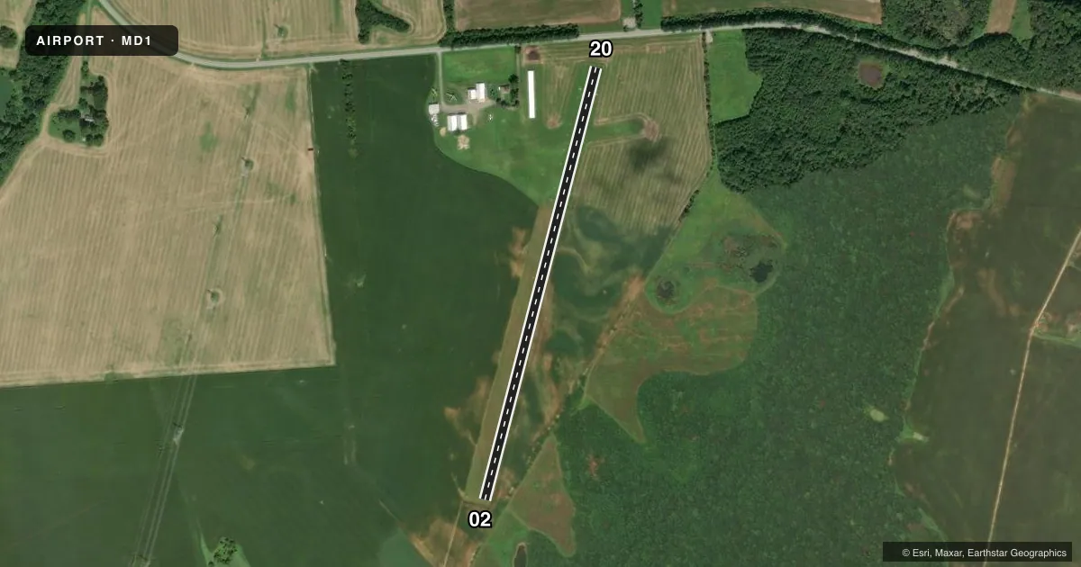
Airport sketch
Runways drawn to scale from FAA survey coordinates, rendered over satellite imagery. Not for navigation.
Approaches & charts
Services on the field
Fuel grades, oxygen, maintenance, ramp storage and lighting — as declared to the FAA by the airport operator.
Fuel & services
- Fuel
- Not available
Ramp & ground
- Transient storage
- Tie-down
- Wind indicator
- Yes
- Segmented circle
- No
Fuel & FBOs
Cheapest 100LL and Jet A on the field and nearby. Always confirm with the FBO before taxi.
Airport notes
Surface conditions, obstructions, local procedures, lighting outages and other notes published with each FAA cycle.
General notes
- GLIDERS, HANG-GLIDERS, POWERED PRCHTS, ULTRALIGHT ACT, ON AND INVOF AIRPORT.
- RWY THR AND SIDES MARKED WITH WHITE CONES.
- FOR CD CTC PHILADELPHIA APCH AT 800-354-9884.
Approach & departure obstructions
- 20RWY 20 DSPLCD THR MARKED WITH 3 WHITE CONES ON BOTH SIDES.
- 20APCH RATIO 20:1 TO DSPLCD THLR.
VFR map & nearby airports
VFR sectional. Tap any ICAO chip to open that airport.
Key facts · MD1
Answer card- ICAO
- MD1
- Name
- MASSEY AERODROME
- Location
- MASSEY, MARYLAND
- Elevation
- 73 ft MSL
- Traffic pattern altitude
- 1,073 ft MSL (1,000 AGL)
- Control tower
- Non-towered (use CTAF)
- Total runways
- 1
- Longest runway
- 02/20 · 3,000 ft
- Published ILS approaches
- 0
- Published frequencies
- 1
- Magnetic variation
- 12°
- Current flight rules
- VFR
- Current wind
- 000° at 0 kt
- Favored runway now
- –
Massey Aerodrome is in Massey, Maryland. Field elevation is 73 ft MSL. It has one runway. Runway 02/20 is 3,000 ft of turf, so plan for soft-field performance and keep an eye on braking and rollout distance. The airport is non-towered. CTAF is 122.9.
No ILS approaches are published here. Pattern altitude is not published in the facts, so use the current Chart Supplement before you go. Runway markings matter here. The runway threshold and sides are marked with white cones. Runway 20 has a displaced threshold marked with three white cones on both sides. The published approach ratio to that displaced threshold is 20 to 1.
Traffic in the area can include gliders, hang-gliders, powered parachutes and ultralights. Give yourself extra scan time in the pattern and on final. For clearance delivery, contact Philadelphia Approach at 800-354-9884. There are no on-field FBOs listed in the facts. Contact the airport operator directly before arrival if you need fuel or other services. If you are planning a first visit, verify current pattern details, any local procedures and the latest field condition before departure.