METAR & TAF KESN
Current METAR
Observed 15:45Z
KESN 271545Z VRB04KT 10SM SCT018 26/21 A2986
- Wind
- VAR @ 4 kt
- Visibility
- 10 SM
- Temp / Dew
- 26°C / 21°C
- Altimeter
- 29.86 inHg
- Clouds
- SCT
- Density alt
- 1,484 ft
- Ceiling
- Unlimited
- Rules
- VFR
Airport info & contacts
Manager on record, flight service, ARTCC, attendance schedule and pattern altitude — published by the FAA and refreshed every 28 days.
Location
- From city
- 2 NM N
- VFR sectional
- WASHINGTON
- ARTCC
- ZDC · WASHINGTON
- NOTAM facility
- ESN (NOTAM-D)
Airport manager
- Name
- MICAH RISHER
- Phone
- 410-770-8055
- Address
- 29051 CORKRAN ROAD, EASTON MD 21601
Flight service · Hours
- FSS DCA
- LEESBURG1-800-WX-BRIEF
- Attendance
- 0800-DUSK
Frequencies
Tap any row to copy the frequency to your clipboard.
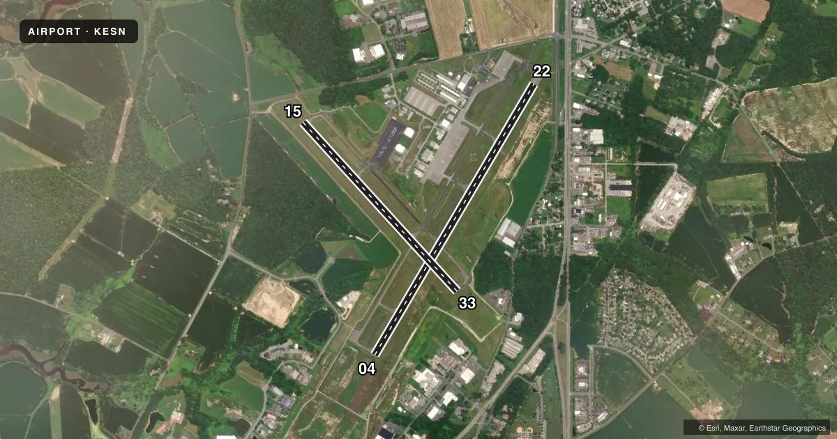
Runways & pattern
Full pagePattern entry · RWY 04
LEFT TRAFFIC| Runway | Heading (°M) | Length | Surface | Traffic |
|---|---|---|---|---|
| 04/22Favored | 21° / 201° | 5,500 ft | ASPH | 22 R |
| 15/33 | 128° / 308° | 4,003 ft | ASPH | 33 R |
Runway end performance
| End | TORA | TODA | ASDA | LDA | VGSI | Approach lights | Obstruction |
|---|---|---|---|---|---|---|---|
| 04 | 5,175' | 5,500' | 4,775' | 4,775' | PAPI 4-box left(3°) | — | — |
| 22 | 5,500' | 5,500' | 5,500' | 5,175' | PAPI 4-box left(3°) | — | — |
| 15 | — | — | — | — | PAPI 2-box left(3.5°) | — | — |
| 33 | — | — | — | — | PAPI 2-box left(3.5°) | — | 77', trees, 1999' from thr, 281' R of cntrln, slope 23 |
Declared distances in feet. TORA = takeoff run available, TODA = takeoff distance, ASDA = accelerate-stop, LDA = landing distance.
Airport sketch
Runways drawn to scale from FAA survey coordinates, rendered over satellite imagery. Not for navigation.
Approaches & charts
ILS · 1
Services on the field
Fuel grades, oxygen, maintenance, ramp storage and lighting — as declared to the FAA by the airport operator.
Fuel & services
- Fuel
- 100LLA
- Oxygen (bottled)
- Low pressure
- Oxygen (bulk)
- Not available
- Airframe repair
- Major
- Power plant repair
- Major
- Other services
- AVNCS,CHTR,INSTR,RNTL,SALES
Ramp & ground
- Transient storage
- Tie-down
- Landing fee
- No fee published
- Customs
- Not available
- Lighting schedule
- SEE RMK
- Beacon schedule
- SS-SR
- Beacon
- White / Green (civil land)(WG)
- Wind indicator
- Lighted
- Segmented circle
- Yes
Fuel & FBOs
Cheapest 100LL and Jet A on the field and nearby. Always confirm with the FBO before taxi.
Airport notes
Surface conditions, obstructions, local procedures, lighting outages and other notes published with each FAA cycle.
General notes
- DEER, BIRDS, OTHER WILDLIFE ON & INVOF ARPT.
- RWY 15/33 DISTANCE MARKERS EVERY 1000 FT WEST SIDE RWY.
- FOR CD WHEN ATCT IS CLSD CTC POTOMAC APCH AT 866-429-5882.
- NOISE ABATEMENT FOR RUNWAY 22: CONTINUE STRAIGHT OUT OR MAKE A RIGHT TURN TO AVOID OVERFLIGHT OF THE TOWN OF EASTON. DEPARTURES SHOULD AVOID OVERFLIGHT OF THE TOWN OF EASTON BELOW 2000 FT.
- AIRCRAFT SHOULD AVOID OVERFLIGHT OF THE TOWN OF EASTON AND RESIDENTIAL AREAS NEAR THE AIRPORT TO THE EXTENT POSSIBLE.
- NOISE ABATEMENT FOR RUNWAY 4: IF TRAFFIC PERMITS, MAKE A SLIGHT LEFT TURN AFTER DEPARTURE TO AVOID OVERFLYING RETIREMENT COMMUNITY.
Lighting notes
- WHEN TWR CLSD ACTVT REILS RWY 15, 22, & 33; HIRL RWY 04/22; MIRL RWY 15/33 - CTAF.
Other notes
- THIS AIRPORT HAS BEEN SURVEYED BY THE NATIONAL GEODETIC SURVEY.
- EXISTED PRIOR TO 1959.
- TPA FOR JET ACFT 1526 FT AGL; ALL OTHER ACFT 1026 FT AGL.
VFR map & nearby airports
VFR sectional. Tap any ICAO chip to open that airport.
Key facts · KESN
Answer card- ICAO
- KESN
- Name
- EASTON/NEWNAM FLD
- Location
- EASTON, MARYLAND
- Elevation
- 72.2 ft MSL
- Traffic pattern altitude
- 1,072.2 ft MSL (1,000 AGL)
- Control tower
- Towered · 0600-2200
- Total runways
- 2
- Longest runway
- 04/22 · 5,500 ft
- Published ILS approaches
- 1
- Published frequencies
- 9
- Magnetic variation
- 10°
- Current flight rules
- VFR
- Current wind
- 000° at 4 kt
- Favored runway now
- RWY 04
Easton/Newnam Fld sits in Easton, Maryland. Field elevation is 72.2 ft MSL. The airport has 2 asphalt runways. The longest is runway 04/22 at 5,500 ft. Runway 15/33 is 4,003 ft. The tower is open daily from 0600 to 2200. When the tower is closed, use CTAF 118.525. Expect the published lighting procedures for each runway end.
There is 1 ILS approach at KESN. It serves runway 04. The published pattern altitude is not standard for all aircraft here. Jets use 1,526 ft AGL. All other aircraft use 1,026 ft AGL. That is worth checking before you join the pattern.
Four on-field FBOs are listed. NexGen Flight Solutions carries 100LL and Jet A. Easton Jet Service carries 100LL, Jet A and Jet A Prist. Trident Aircraft carries 100LL and Jet A. Maryland Air carries 100LL, Jet A and Jet A Prist. If you need current ramp details or service status, call them directly.
Noise abatement matters here. Runway 04 departures should make a slight left turn if traffic permits to avoid the retirement community. Runway 22 departures should go straight out or make a right turn to avoid the town of Easton. Departures should avoid overflying town below 2,000 ft. Wildlife is also a factor. Deer and birds are reported on and near the field.