METAR & TAF W29
Current METAR
Observed 04:15Z
KW29 270415Z AUTO 17008KT 10SM BKN100 24/20 A2987 RMK AO2 T02450203
- Wind
- 170° @ 8 kt
- Visibility
- 10 SM
- Temp / Dew
- 24°C / 20°C
- Altimeter
- 29.87 inHg
- Clouds
- BKN
- Density alt
- 1,160 ft
- Ceiling
- 10,000 ft AGL
- Rules
- VFR
Airport info & contacts
Manager on record, flight service, ARTCC, attendance schedule and pattern altitude — published by the FAA and refreshed every 28 days.
Location
- From city
- 1 NM W
- VFR sectional
- WASHINGTON
- Pattern altitude
- 1,200 ft AGL · 1,215 ft MSL
- ARTCC
- ZDC · WASHINGTON
- NOTAM facility
- W29 (NOTAM-D)
Airport manager
- Name
- LINDA K. STEINER
- Phone
- 410-643-4364
- Address
- 202 AIRPORT RD, STEVENSVILLE MD 21666
Flight service · Hours
- FSS DCA
- LEESBURG1-800-WX-BRIEF
- Attendance
- MON-SAT · 0730-1630
- SUN · UNATTND
- FED HOLS · UNATTND
Frequencies
Tap any row to copy the frequency to your clipboard.
Runways & pattern
Full pagePattern entry · RWY 11
LEFT TRAFFICRunway end performance
| End | TORA | TODA | ASDA | LDA | VGSI | Approach lights | Obstruction |
|---|---|---|---|---|---|---|---|
| 11 | — | — | — | — | PAPI 2-box left(3°) | — | — |
| 29 | — | — | — | — | PAPI 2-box left(3°) | — | — |
Declared distances in feet. TORA = takeoff run available, TODA = takeoff distance, ASDA = accelerate-stop, LDA = landing distance.
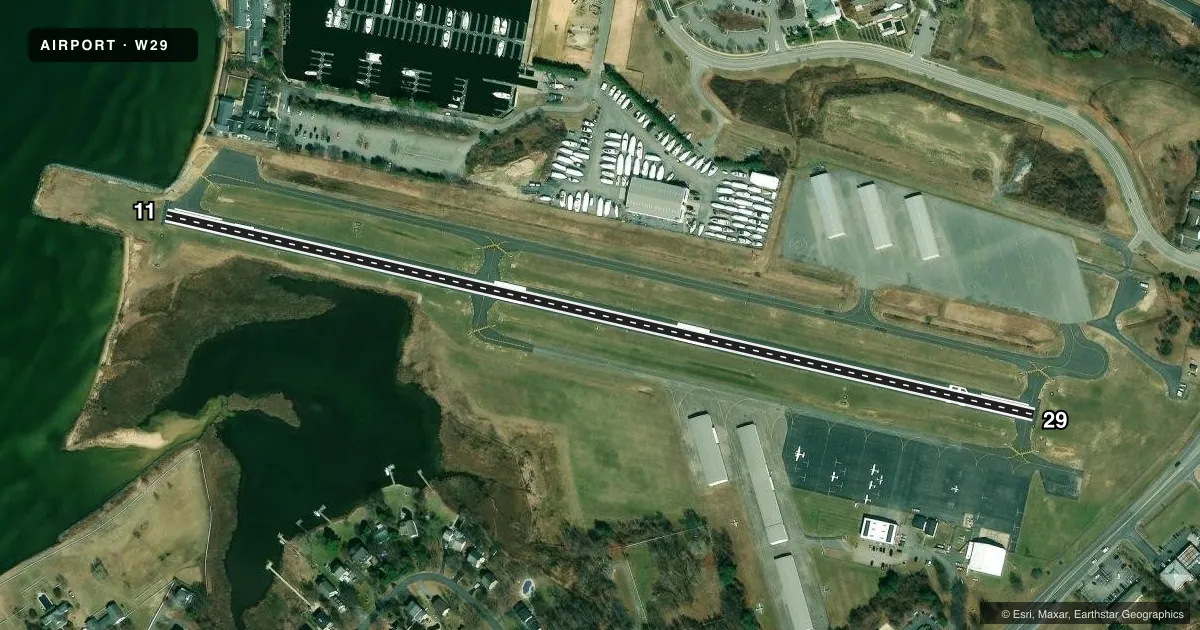
Airport sketch
Runways drawn to scale from FAA survey coordinates, rendered over satellite imagery. Not for navigation.
Approaches & charts
Services on the field
Fuel grades, oxygen, maintenance, ramp storage and lighting — as declared to the FAA by the airport operator.
Fuel & services
- Fuel
- 100LL
- Oxygen (bottled)
- Not available
- Oxygen (bulk)
- Not available
- Airframe repair
- Major
- Power plant repair
- Major
- Other services
- INSTR,RNTL,SALES
Ramp & ground
- Transient storage
- Tie-down
- Landing fee
- No fee published
- Customs
- Not available
- Lighting schedule
- SEE RMK
- Beacon schedule
- SS-SR
- Beacon
- White / Green (civil land)(WG)
- Wind indicator
- Lighted
- Segmented circle
- No
Fuel & FBOs
Cheapest 100LL and Jet A on the field and nearby. Always confirm with the FBO before taxi.
Airport notes
Surface conditions, obstructions, local procedures, lighting outages and other notes published with each FAA cycle.
General notes
- TGL OPS NA.
- WILDLIFE ON & INVOF ARPT.
- NOISE ABATEMENT PROC IN EFCT - AMGR. NOISE SENSITIVE RESIDENTIAL AREA S OF ARPT; ENTER DOWNWIND FOR RWY 29 OVER WATER TWR S OF FLD.
- ALERT HELI 8 NM EAST OF ARPT.
- FOR CD CTC POTOMAC APCH AT 866-429-5882.
- ROTOR CRAFT: USE R PAT FOR RWY 29. AT ALL OTR TIMES, USE L TFC PAT.
Lighting notes
- DUSK-DAWN; ACTVT REIL RWY 11 & 29; MIRL RWY 11/29 - CTAF. PAPI RWY 11 & RWY 29 OPRS CONSLY.
Fuel notes
- 100LLSELF SERVE AVBL H24 WITH CREDIT CARD.
Approach & departure obstructions
- 11PAPI UNUSBL BYD 5 DEGS LEFT OF CNTRLN.
Other notes
- PRKG FEE.
VFR map & nearby airports
VFR sectional. Tap any ICAO chip to open that airport.
Key facts · W29
Answer card- ICAO
- W29
- Name
- BAY BRIDGE
- Location
- STEVENSVILLE, MARYLAND
- Elevation
- 14.5 ft MSL
- Traffic pattern altitude
- 1,214.5 ft MSL (1,200 AGL)
- Control tower
- Non-towered (use CTAF)
- Total runways
- 1
- Longest runway
- 11/29 · 2,714 ft
- Published ILS approaches
- 0
- Published frequencies
- 4
- Magnetic variation
- 11°
- Current flight rules
- VFR
- Current wind
- 170° at 8 kt
- Favored runway now
- RWY 11
Bay Bridge Airport sits in Stevensville, Maryland. Field elevation is 14.5 ft MSL. The airport has one runway. Runway 11/29 is asphalt and measures 2,714 ft. There is no control tower. Potomac Approach handles clearance delivery and approach or departure services. No ILS approaches are published.
The pattern altitude is 1,200 ft AGL, which is 1,214.5 ft MSL. That matters here because the field is low and the pattern sits close to sea level. The on-field FBO is Bay Bridge Airport. It carries 100LL. Self-serve 100LL is available 24 hours with a credit card.
Several published remarks matter for a first visit. Touch-and-go operations are not authorized. Noise abatement procedures are in effect. There is a noise-sensitive residential area south of the airport. For runway 29, enter downwind over water with the tower south of the field. Wildlife is reported on and near the airport. A helicopter is also reported 8 NM east of the field. From dusk to dawn, runway end identifier lights and medium intensity runway lights are activated via CTAF. The PAPI on both runway ends operates continuously. The airport also charges a parking fee. Check the current FAA Chart Supplement before you go for the latest published details.