METAR & TAF 3W3
3W3 does not publish a METAR.
Showing the nearest reporting station: KESN (EASTON/NEWNAM FLD) · 15.2 NM away. Conditions at 3W3 may differ.
METAR · KESN
Observed 20:45Z
KESN 262045Z 00000KT 10SM CLR 29/15 A2986
- Wind
- 000° @ 0 kt
- Visibility
- 10 SM
- Temp / Dew
- 29°C / 15°C
- Altimeter
- 29.86 inHg
- Clouds
- CLR
- Density alt
- 1,767 ft
- Ceiling
- Unlimited
- Rules
- VFR
Airport info & contacts
Manager on record, flight service, ARTCC, attendance schedule and pattern altitude — published by the FAA and refreshed every 28 days.
Location
- From city
- 5 NM SW
- VFR sectional
- WASHINGTON
- Pattern altitude
- 990 ft AGL · 1,000 ft MSL
- ARTCC
- ZDC · WASHINGTON
- NOTAM facility
- DCA (NOTAM-D)
Airport manager
- Name
- MR. PETE MEYER
- Phone
- 301-456-0566
- Address
- 410 KENTMORR RD, STEVENSVILLE MD 21666
Flight service · Hours
- FSS DCA
- LEESBURG1-800-WX-BRIEF
- Attendance
- Unattended
Frequencies
Tap any row to copy the frequency to your clipboard.
Runways & pattern
Full pagePattern entry · RWY 10
LEFT TRAFFICRunway end performance
| End | TORA | TODA | ASDA | LDA | VGSI | Approach lights | Obstruction |
|---|---|---|---|---|---|---|---|
| 10 | — | — | — | — | — | — | 44', trees, 190' from thr, 40' R of cntrln, slope 4 |
| 28 | — | — | — | — | — | — | 67', trees, 693' from thr, 36' R of cntrln, slope 10 |
Declared distances in feet. TORA = takeoff run available, TODA = takeoff distance, ASDA = accelerate-stop, LDA = landing distance.
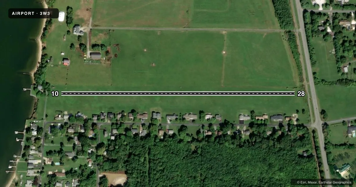
Airport sketch
Runways drawn to scale from FAA survey coordinates, rendered over satellite imagery. Not for navigation.
Approaches & charts
Services on the field
Fuel grades, oxygen, maintenance, ramp storage and lighting — as declared to the FAA by the airport operator.
Fuel & services
- Fuel
- Not available
- Oxygen (bottled)
- Not available
- Oxygen (bulk)
- Not available
- Airframe repair
- Not available
- Power plant repair
- Not available
Ramp & ground
- Transient storage
- Not published
- Landing fee
- No fee published
- Customs
- Not available
- Wind indicator
- Yes
- Segmented circle
- No
Fuel & FBOs
Cheapest 100LL and Jet A on the field and nearby. Always confirm with the FBO before taxi.
Airport notes
Surface conditions, obstructions, local procedures, lighting outages and other notes published with each FAA cycle.
General notes
- NO NIGHT OPNS.
- HELICOPTERS REQD TO USE STD TFC PAT.
- RY 10/28 MAY BE SOFT & WET.
- PREFERRED CALM OR CROSSWIND RWY 28; FOR NOISE ABATEMENT.
- PREFERRED 90 DEGREE CROSSWIND RWY 28; FOR NOISE ABATEMENT.
- UNLIMITED VEHICLE ACCESS TO ACFT MOVEMENT AREAS.
- NUMEROUS BIRDS, DEER, OTHER WILDLIFE ON & INVOF ARPT.
- TAXI & PARK NORTH SIDE OF RY.
- FOR CD CTC POTOMAC APCH AT 866-429-5882.
Approach & departure obstructions
- 10RWY 10/28 DSPLCD THRS MKD W/ORANGE CONES.
- 10RWY 10 APCH RATIO 20:1 TO DSPLCD THLD AT CNTRLN.
- 28RWY 28 APCH RATIO 20:1 TO DSPLCD THLD.
Other notes
- IN OPN PRIOR TO 1959.
VFR map & nearby airports
VFR sectional. Tap any ICAO chip to open that airport.
Key facts · 3W3
Answer card- ICAO
- 3W3
- Name
- KENTMORR AIRPARK
- Location
- STEVENSVILLE, MARYLAND
- Elevation
- 10 ft MSL
- Traffic pattern altitude
- 1,000 ft MSL (990 AGL)
- Control tower
- Non-towered (use CTAF)
- Total runways
- 1
- Longest runway
- 10/28 · 2,400 ft
- Published ILS approaches
- 0
- Published frequencies
- 1
- Magnetic variation
- 10°
- Current flight rules
- VFR
- Current wind
- 000° at 0 kt
- Favored runway now
- –
Kentmorr Airpark is in Stevensville, Maryland on the eastern shore of the Chesapeake Bay. Field elevation is 10 ft MSL. The airport has one runway. Runway 10/28 is 2,400 ft of turf, so plan for soft or wet surface conditions when the field has seen rain. There is no control tower. CTAF is 122.9.
No ILS approaches are published here. Pattern altitude is 990 ft AGL, which is 1,000 ft MSL. Published remarks also call out displaced thresholds on both ends, marked with orange cones. Runway 28 is the preferred crosswind runway for noise abatement. Runway 28 is also the preferred calm wind runway. Taxi and parking are on the north side of the runway.
First-time visitors should pay close attention to wildlife. Birds and deer are reported on and near the airport. Helicopters are required to use the standard traffic pattern. There are no on-field FBOs listed, so verify fuel and services with the airport operator or the FBO directly by phone before you go. Night operations are not allowed. The field has unlimited vehicle access to aircraft movement areas, so keep a sharp lookout on the ground as well as in the pattern.