METAR & TAF KRJD
KRJD does not publish a METAR.
Showing the nearest reporting station: KESN (EASTON/NEWNAM FLD) · 13.7 NM away. Conditions at KRJD may differ.
METAR · KESN
Observed 15:45Z
KESN 271545Z VRB04KT 10SM SCT018 26/21 A2986
- Wind
- VAR @ 4 kt
- Visibility
- 10 SM
- Temp / Dew
- 26°C / 21°C
- Altimeter
- 29.86 inHg
- Clouds
- SCT
- Density alt
- 1,474 ft
- Ceiling
- Unlimited
- Rules
- VFR
Airport info & contacts
Manager on record, flight service, ARTCC, attendance schedule and pattern altitude — published by the FAA and refreshed every 28 days.
Location
- From city
- 2 NM NE
- VFR sectional
- WASHINGTON
- ARTCC
- ZDC · WASHINGTON
- NOTAM facility
- DCA (NOTAM-D)
Airport manager
- Name
- JOHN GOODEN
- Phone
- 302-270-2227
- Address
- 3532 TURKEY POINT ROAD, VIOLA DE 19979
Flight service · Hours
- FSS DCA
- LEESBURG1-800-WX-BRIEF
- Attendance
- UNATTENDED
Frequencies
Tap any row to copy the frequency to your clipboard.
Runways & pattern
Full pagePattern entry · RWY 30
RIGHT TRAFFICRunway end performance
| End | TORA | TODA | ASDA | LDA | VGSI | Approach lights | Obstruction |
|---|---|---|---|---|---|---|---|
| 12 | — | — | — | — | — | — | 27', pline, 1170' from thr, 0' R of cntrln, slope 35 |
| 30 | — | — | — | — | — | — | 34', trees, 769' from thr, 191' R of cntrln, slope 16 |
Declared distances in feet. TORA = takeoff run available, TODA = takeoff distance, ASDA = accelerate-stop, LDA = landing distance.
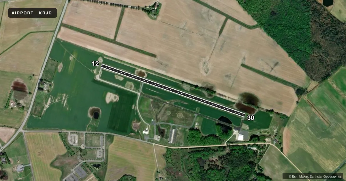
Airport sketch
Runways drawn to scale from FAA survey coordinates, rendered over satellite imagery. Not for navigation.
Approaches & charts
Services on the field
Fuel grades, oxygen, maintenance, ramp storage and lighting — as declared to the FAA by the airport operator.
Fuel & services
- Fuel
- Not available
- Airframe repair
- Major
- Power plant repair
- Major
- Other services
- AGRI,PAJA
Ramp & ground
- Transient storage
- Tie-down
- Landing fee
- No fee published
- Lighting schedule
- SEE RMK
- Beacon schedule
- SEE RMK
- Beacon
- White / Green (civil land)(WG)
- Wind indicator
- Lighted
- Segmented circle
- Yes
Fuel & FBOs
Cheapest 100LL and Jet A on the field and nearby. Always confirm with the FBO before taxi.
Airport notes
Surface conditions, obstructions, local procedures, lighting outages and other notes published with each FAA cycle.
General notes
- TURF AREAS ADJACENT TO ACFT MOVEMENT AREAS SOFT WHEN WET.
- UNLIMITED VEHICLE ACCESS TO ACFT MOVEMENT AREAS.
- BIRDS, DEER & WILDLIFE ON & INVOF ARPT.
- TWY/APN PAVEMENTS ARE FAILING WITH LOOSE AGGREGATE AND ALLIGATOR CRACKING.
- FOR CD CTC DOVER APCH AT 302-677-3940.
Lighting notes
- ACTVT ARPT BEACON - CTAF.
- ACTIVATE REIL RWY 12 & 30; LIRL RWY 12/30 - CTAF.
Approach & departure obstructions
- 12FADED, CRACK SEAL THRU MRKGS.
- 30FADED, CRACK SEAL THRU MRKGS.
- 12THR BARS AND RWY NRS ARE HALF SIZE.
- 30THR BARS AND RWY NRS ARE HALF SIZE.
Other notes
- VFR USE ONLY.
- UNICOM UNMON.
VFR map & nearby airports
VFR sectional. Tap any ICAO chip to open that airport.
Key facts · KRJD
Answer card- ICAO
- KRJD
- Name
- GOODEN AIRPARK
- Location
- RIDGELY, MARYLAND
- Elevation
- 64 ft MSL
- Traffic pattern altitude
- 1,064 ft MSL (1,000 AGL)
- Control tower
- Non-towered (use CTAF)
- Total runways
- 1
- Longest runway
- 12/30 · 3,214 ft
- Published ILS approaches
- 0
- Published frequencies
- 7
- Magnetic variation
- 12°
- Current flight rules
- VFR
- Current wind
- 000° at 4 kt
- Favored runway now
- RWY 30
Gooden Airpark sits near Ridgely, Maryland. Field elevation is 64 ft MSL. The airport has one runway. Runway 12/30 is 3,214 ft long with an asphalt surface. There is no control tower. Pattern altitude is not published, so use the standard 1,000 ft AGL for light piston operations unless the current Chart Supplement says otherwise.
No ILS approaches are published here. CTAF and UNICOM are 122.8. UNICOM is unmonitored. For clearance delivery, contact Dover Approach at 302-677-3940. The airport beacon is activated on the CTAF frequency. Runway end identifier lights and the low intensity runway lights for 12/30 are also activated on CTAF.
First-time pilots should pay attention to the pavement condition. The Chart Supplement notes failing taxiway and apron pavement with loose aggregate and alligator cracking. Turf beside the movement areas can be soft when wet. Wildlife is also a factor here. Birds, deer and other wildlife have been reported on and near the airport. Runway 12 and 30 markings are faded. The threshold bars and runway numbers on both ends are half size. There is unlimited vehicle access to aircraft movement areas. Keep a sharp lookout while taxiing.