METAR & TAF D74
D74 does not publish a METAR.
Showing the nearest reporting station: KGED (DELAWARE COASTAL) · 15.3 NM away. Conditions at D74 may differ.
METAR · KGED
Observed 15:54Z
KGED 271554Z AUTO VRB03KT 10SM SCT032 27/19 A2985 RMK AO2 SLP109 T02720194
- Wind
- VAR @ 3 kt
- Visibility
- 10 SM
- Temp / Dew
- 27°C / 19°C
- Altimeter
- 29.85 inHg
- Clouds
- SCT
- Density alt
- 1,607 ft
- Ceiling
- Unlimited
- Rules
- VFR
Airport info & contacts
Manager on record, flight service, ARTCC, attendance schedule and pattern altitude — published by the FAA and refreshed every 28 days.
Location
- From city
- 2 NM SW
- VFR sectional
- WASHINGTON
- ARTCC
- ZDC · WASHINGTON
- NOTAM facility
- MIV (NOTAM-D)
Airport manager
- Name
- ALLEN CHORMAN
- Phone
- 302-645-9225
- Address
- 2057 NINE FT RD, GREENWOOD DE 19952
Flight service · Hours
- FSS MIV
- MILLVILLE1-800-WX-BRIEF
- Attendance
- MON-FRI · 0830-DUSK
Frequencies
Tap any row to copy the frequency to your clipboard.
Runways & pattern
Full pagePattern entry · RWY 34
LEFT TRAFFICRunway end performance
| End | TORA | TODA | ASDA | LDA | VGSI | Approach lights | Obstruction |
|---|---|---|---|---|---|---|---|
| 34 | — | — | — | — | — | — | 24', pole, 250' from thr, 80' R of cntrln, slope 2 |
Declared distances in feet. TORA = takeoff run available, TODA = takeoff distance, ASDA = accelerate-stop, LDA = landing distance.
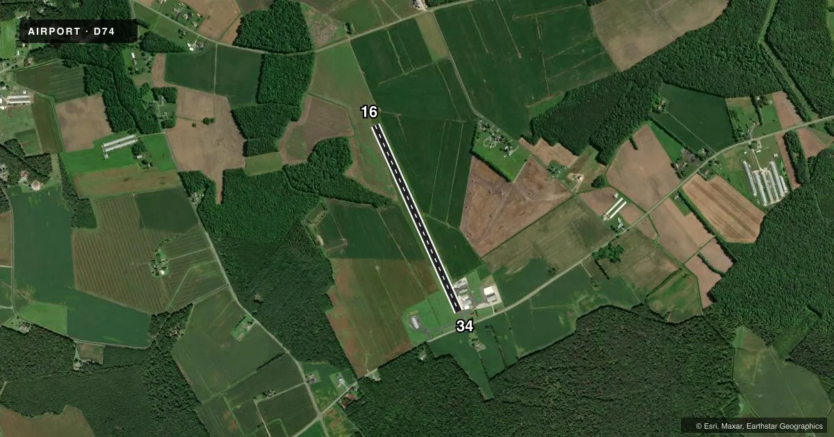
Airport sketch
Runways drawn to scale from FAA survey coordinates, rendered over satellite imagery. Not for navigation.
Approaches & charts
Services on the field
Fuel grades, oxygen, maintenance, ramp storage and lighting — as declared to the FAA by the airport operator.
Fuel & services
- Fuel
- Not available
- Airframe repair
- Major
- Power plant repair
- Major
Ramp & ground
- Transient storage
- Not published
- Lighting schedule
- SEE RMK
- Beacon schedule
- SEE RMK
- Beacon
- White / Green (civil land)(WG)
- Wind indicator
- Yes
- Segmented circle
- No
Fuel & FBOs
Cheapest 100LL and Jet A on the field and nearby. Always confirm with the FBO before taxi.
Airport notes
Surface conditions, obstructions, local procedures, lighting outages and other notes published with each FAA cycle.
General notes
- AGRICULTURE SPRAYING ACTIVITY ON & INVOF ARPT.
- LOADING PAD ADJACENT TO EAST SIDE RY 34.
- FOR CD CTC WASHINGTON ARTCC AT 703-771-3587.
Lighting notes
- ACTVT ROTG BCN - CTAF.
- ACTVT REIL RWY 16 & 34; LIRL RWY 16/34 - CTAF.
Other notes
- PRVDD VFR, PRIVATE USE, THAT 41 FT CEDAR TREE S OF ARPT LOWERED TO GIVE 20:1 APCH SFC; RY END BE DSPLCD 90 FT DUE TO PUBLIC ROAD S OF RY; WIDTH OF PRIMARY SFC SHOULD BE 250 FT WITH OBSTRUCTIONS CLEARED 125 FT ON EITHER SIDE OF RY.
VFR map & nearby airports
VFR sectional. Tap any ICAO chip to open that airport.
Key facts · D74
Answer card- ICAO
- D74
- Name
- CHORMAN
- Location
- FARMINGTON, DELAWARE
- Elevation
- 65 ft MSL
- Traffic pattern altitude
- 1,065 ft MSL (1,000 AGL)
- Control tower
- Non-towered (use CTAF)
- Total runways
- 1
- Longest runway
- 16/34 · 3,585 ft
- Published ILS approaches
- 0
- Published frequencies
- 1
- Magnetic variation
- 11°
- Current flight rules
- VFR
- Current wind
- 000° at 3 kt
- Favored runway now
- RWY 34
Chorman Airport (D74) sits in Farmington, Delaware. The field elevation is 65 ft MSL. It has one runway, 16/34, which is 3,585 ft long and paved with asphalt. This is a private-use airport. It is provided for VFR operations. No control tower is listed. CTAF is 122.9.
No ILS approaches are published here. The pattern altitude is not published in the facts, so use the current Chart Supplement before you fly. The published remarks matter here. The rotating beacon is activated by CTAF. Runway end identifier lights are also activated for 16 and 34. Low intensity runway lights for 16/34 are CTAF-activated too. There is a loading pad on the east side of runway 34. A 41-foot cedar tree south of the airport and a displaced threshold on the south end are both part of the published runway environment. Agriculture spraying also occurs on and near the field.
There are no on-field FBOs listed in the facts. Contact the airport operator directly before arrival, or call the field on CTAF for current FBO availability. For clearance delivery, Washington ARTCC is listed in the remarks. If you are planning a first visit, treat this as a private VFR field with runway environment details that deserve a careful preflight review.