METAR & TAF KGED
Current METAR
Observed 15:54Z
KGED 271554Z AUTO VRB03KT 10SM SCT032 27/19 A2985 RMK AO2 SLP109 T02720194
- Wind
- VAR @ 3 kt
- Visibility
- 10 SM
- Temp / Dew
- 27°C / 19°C
- Altimeter
- 29.85 inHg
- Clouds
- SCT
- Density alt
- 1,593 ft
- Ceiling
- Unlimited
- Rules
- VFR
Airport info & contacts
Manager on record, flight service, ARTCC, attendance schedule and pattern altitude — published by the FAA and refreshed every 28 days.
Location
- From city
- 2 NM SE
- VFR sectional
- WASHINGTON
- ARTCC
- ZDC · WASHINGTON
- NOTAM facility
- GED (NOTAM-D)
Airport manager
- Name
- ROBERT L. BRYANT
- Phone
- 302-855-7774
- Address
- 21553 RUDDER LANE, GEORGETOWN DE 19947
Flight service · Hours
- FSS MIV
- MILLVILLE1-800-WX-BRIEF
- Attendance
- 0800-1800
Frequencies
Tap any row to copy the frequency to your clipboard.
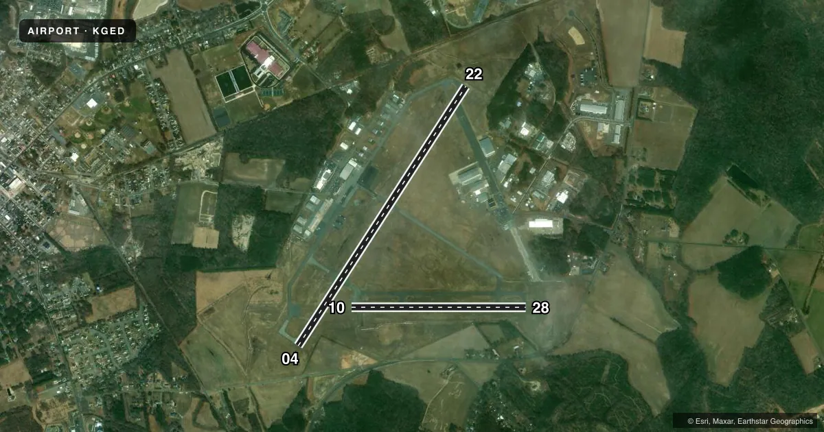
Runways & pattern
Full pagePattern entry · RWY 04
LEFT TRAFFIC| Runway | Heading (°M) | Length | Surface | Traffic |
|---|---|---|---|---|
| 04/22Favored | 21° / 201° | 5,500 ft | ASPH | Standard L |
| 10/28 | 78° / 258° | 3,109 ft | ASPH | Standard L |
Runway end performance
| End | TORA | TODA | ASDA | LDA | VGSI | Approach lights | Obstruction |
|---|---|---|---|---|---|---|---|
| 04 | — | — | — | — | PAPI 4-box left(3°) | MALS | 49', trees, 1258' from thr, 140' R of cntrln, slope 21 |
| 22 | — | — | — | — | PAPI 4-box left(3°) | — | — |
| 10 | — | — | — | — | PAPI 2-box left(3.5°) | — | — |
| 28 | — | — | — | — | PAPI 2-box left(3°) | — | — |
Declared distances in feet. TORA = takeoff run available, TODA = takeoff distance, ASDA = accelerate-stop, LDA = landing distance.
Airport sketch
Runways drawn to scale from FAA survey coordinates, rendered over satellite imagery. Not for navigation.
Approaches & charts
Services on the field
Fuel grades, oxygen, maintenance, ramp storage and lighting — as declared to the FAA by the airport operator.
Fuel & services
- Fuel
- 100LLA
- Oxygen (bottled)
- Not available
- Airframe repair
- Major
- Power plant repair
- Major
- Other services
- AMB,CHTR,INSTR,RNTL,SALES
Ramp & ground
- Transient storage
- Tie-down
- Landing fee
- No fee published
- Customs
- Not available
- Lighting schedule
- SEE RMK
- Beacon schedule
- SS-SR
- Beacon
- White / Green (civil land)(WG)
- Wind indicator
- Lighted
- Segmented circle
- Yes
Fuel & FBOs
Cheapest 100LL and Jet A on the field and nearby. Always confirm with the FBO before taxi.
Airport notes
Surface conditions, obstructions, local procedures, lighting outages and other notes published with each FAA cycle.
General notes
- PAEW WITHIN SAFETY AREA OF RWYS & TWYS.
- BIRDS, DEER, AND OTHER WILDLIFE INVOF RWYS.
- FOR CD IF UNA VIA GCO FREQ, CTC DOVER APCH AT 302-677-3940. IF DOVER APCH UNA, CTC WASHINGTON ARTCC AT 703-771-3587.
- GCO AVBL ON FREQ 125.55.
- FBO HRS 0800-1800 LST. FOR SVC/FUEL AFT HRS CALL 302-855-2355.
Lighting notes
- ACTVT MALS RWY 4; REIL RWY 04, 22, 10, 28; MIRL RWY 04/22 & 10/28 - CTAF.
Runway surface & condition
- 04/22RWY 04/22 SUBJ TO FQT RWY ACFT BACKTAXI OPS.
Other notes
- EXISTED PRIOR TO 1959.
- 1ARPT UNATNDD THANKSGIVING DAY AND CHRISTMAS DAY.
- MANAGERROBERT.BRYANT@SUSSEXCOUNTYDE.GOV.
- AMBPARK & TIE DOWN FEES.
VFR map & nearby airports
VFR sectional. Tap any ICAO chip to open that airport.
Key facts · KGED
Answer card- ICAO
- KGED
- Name
- DELAWARE COASTAL
- Location
- GEORGETOWN, DELAWARE
- Elevation
- 53.3 ft MSL
- Traffic pattern altitude
- 1,053.3 ft MSL (1,000 AGL)
- Control tower
- Non-towered (use CTAF)
- Total runways
- 2
- Longest runway
- 04/22 · 5,500 ft
- Published ILS approaches
- 0
- Published frequencies
- 4
- Magnetic variation
- 12°
- Current flight rules
- VFR
- Current wind
- 000° at 3 kt
- Favored runway now
- RWY 04
Delaware Coastal Airport (KGED) sits in Georgetown, Delaware at 53.3 ft MSL. It has two asphalt runways. The longest is Runway 04/22 at 5,500 ft. There is no control tower, so plan to use CTAF 123.0 and UNICOM 123.0 for local traffic. No ILS approaches are published here, so check the current FAA Chart Supplement for the latest instrument options before you go.
The published pattern altitude is not given. Use standard 1,000 ft AGL for light piston operations unless the current Chart Supplement says otherwise. Skyline Aviation is on the field. It carries 100LL and Jet A. Call (302) 855-2355 for service or fuel after hours. Published remarks also note park and tie-down fees apply. The fixed base operator is normally open from 0800 to 1800 local standard time.
This is a busy local airport with some operational points to watch. Runway 04/22 sees frequent backtaxi use. The MALSR is activated on Runway 04. REILs are on all runway ends. Medium intensity runway lights on both runways are controlled by CTAF. Wildlife is also reported near the runways, so keep your scan sharp on taxi and final. For clearance delivery when the ground communications outlet is not usable, contact Dover Approach. If Dover Approach is unavailable, contact Washington ARTCC.