METAR & TAF N06
N06 does not publish a METAR.
Showing the nearest reporting station: KSBY (SALISBURY-OCEAN CITY WICOMICO RGNL) · 12.8 NM away. Conditions at N06 may differ.
METAR · KSBY
Observed 06:13Z
KSBY 270613Z AUTO 00000KT 10SM VCTS FEW120 19/18 A2986 RMK AO2 RAE03 TSE07 P0000 T01940178
- Wind
- 000° @ 0 kt
- Visibility
- 10 SM
- Temp / Dew
- 19°C / 18°C
- Altimeter
- 29.86 inHg
- Clouds
- FEW
- Density alt
- 592 ft
- Ceiling
- Unlimited
- Rules
- VFR
Airport info & contacts
Manager on record, flight service, ARTCC, attendance schedule and pattern altitude — published by the FAA and refreshed every 28 days.
Location
- From city
- 1 NM SW
- VFR sectional
- WASHINGTON
- ARTCC
- ZDC · WASHINGTON
- NOTAM facility
- MIV (NOTAM-D)
Airport manager
- Name
- JEFF CHORMAN
- Phone
- 302-349-5055
- Address
- 30475 EAST MILL RUN, MILTON DE 19968
Flight service · Hours
- FSS MIV
- MILLVILLE1-800-WX-BRIEF
- Attendance
- 0800-DUSK
Frequencies
Tap any row to copy the frequency to your clipboard.
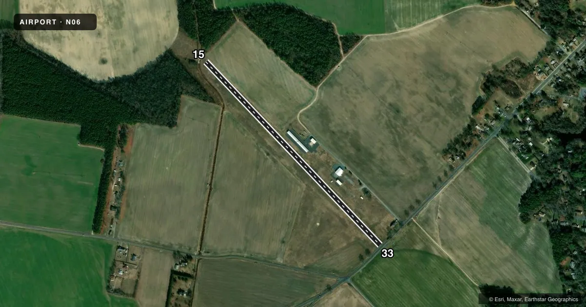
Runways & pattern
Full pagePattern entry · RWY 15
LEFT TRAFFICRunway end performance
| End | TORA | TODA | ASDA | LDA | VGSI | Approach lights | Obstruction |
|---|---|---|---|---|---|---|---|
| 15 | — | — | — | — | — | — | 64', trees, 90' from thr, 110' R of cntrln, slope 1 |
| 33 | — | — | — | — | — | — | 60', tree, 10' from thr, 167' R of cntrln, slope 1 |
Declared distances in feet. TORA = takeoff run available, TODA = takeoff distance, ASDA = accelerate-stop, LDA = landing distance.
Airport sketch
Runways drawn to scale from FAA survey coordinates, rendered over satellite imagery. Not for navigation.
Approaches & charts
Services on the field
Fuel grades, oxygen, maintenance, ramp storage and lighting — as declared to the FAA by the airport operator.
Fuel & services
- Fuel
- Not available
- Oxygen (bottled)
- Not available
- Oxygen (bulk)
- Not available
- Airframe repair
- Not available
- Power plant repair
- Not available
- Other services
- AGRI,PAJA
Ramp & ground
- Transient storage
- Tie-down
- Hangar
- Landing fee
- No fee published
- Customs
- Not available
- Lighting schedule
- SEE RMK
- Beacon schedule
- SEE RMK
- Beacon
- White / Green (civil land)(WG)
- Wind indicator
- Yes
- Segmented circle
- No
Fuel & FBOs
Cheapest 100LL and Jet A on the field and nearby. Always confirm with the FBO before taxi.
Airport notes
Surface conditions, obstructions, local procedures, lighting outages and other notes published with each FAA cycle.
General notes
- FOR CD CTC PATUXENT APCH AT 301-342-3740, WHEN PATUXENT APCH IS CLSD CTC POTOMAC APCH AT 866-640-4124.
- ARPT NO LONGER HOSTS SKYDIVING OPS.
Lighting notes
- ACTVT ROTG BCN - CTAF.
- ACTVT LIRL RWY 15/33 - CTAF.
Approach & departure obstructions
- 33DSPLCD THLD MKD WITH 3 LARGE ORANGE CONES EACH SIDE.
- 33RWY 33 APCH SLP 6:1 TO DSPLCD THLD.
Other notes
- EXISTED PRIOR TO 1959.
- OWNERDEST INC.
VFR map & nearby airports
VFR sectional. Tap any ICAO chip to open that airport.
Key facts · N06
Answer card- ICAO
- N06
- Name
- LAUREL
- Location
- LAUREL, DELAWARE
- Elevation
- 30.1 ft MSL
- Traffic pattern altitude
- 1,030.1 ft MSL (1,000 AGL)
- Control tower
- Non-towered (use CTAF)
- Total runways
- 1
- Longest runway
- 15/33 · 3,175 ft
- Published ILS approaches
- 0
- Published frequencies
- 5
- Magnetic variation
- 12°
- Current flight rules
- VFR
- Current wind
- 000° at 0 kt
- Favored runway now
- –
Laurel Airport (N06) is in Laurel, Delaware. The field elevation is 30.1 ft MSL. It has one runway, 15/33, which is 3,175 ft of turf. No tower is on the field. No ILS approaches are published here.
Pattern altitude is not published. For light piston traffic, use the standard 1,000 ft AGL unless current local guidance says otherwise. The published remarks matter here. Runway 33 has a displaced threshold marked with orange cones. The approach slope to that displaced threshold is 6 to 1. Low intensity runway lights for 15/33 are activated on CTAF. The rotating beacon is also activated on CTAF.
There are no on-field FBOs listed, so plan ahead before arrival. The airport owner is DEST INC. The airport no longer hosts skydiving operations. For clearance delivery, contact Patuxent Approach at 301-342-3740. When Patuxent Approach is closed, contact Potomac Approach at 866-640-4124. First-time pilots should pay attention to the turf surface, the displaced threshold on 33 and the lack of published ILS guidance. Check the current FAA Chart Supplement and call the airport operator or the FBO directly if you need current local procedures.