METAR & TAF 1N5
1N5 does not publish a METAR.
Showing the nearest reporting station: KSBY (SALISBURY-OCEAN CITY WICOMICO RGNL) · 6.7 NM away. Conditions at 1N5 may differ.
METAR · KSBY
Observed 05:54Z
KSBY 270554Z AUTO 13004KT 5SM -TSRA BR FEW036 BKN070 OVC120 20/18 A2987 RMK AO2 RAB35 TSB29 SLP117 P0013 60013 T02000183 10228 20200 58006
- Wind
- 130° @ 4 kt
- Visibility
- 5 SM
- Temp / Dew
- 20°C / 18°C
- Altimeter
- 29.87 inHg
- Clouds
- OVC
- Density alt
- 719 ft
- Ceiling
- 7,000 ft AGL
- Rules
- MVFR
Airport info & contacts
Manager on record, flight service, ARTCC, attendance schedule and pattern altitude — published by the FAA and refreshed every 28 days.
Location
- From city
- 4 NM NW
- VFR sectional
- WASHINGTON
- ARTCC
- ZDC · WASHINGTON
- NOTAM facility
- DCA (NOTAM-D)
Airport manager
- Name
- KYLE KINNAMON
- Phone
- (443) 880-7428
- Address
- 28890 NAYLOR MILL RD, SALISBURY MD 21801
Flight service · Hours
- FSS DCA
- LEESBURG1-800-WX-BRIEF
- Attendance
- DAWN-DUSK
Frequencies
Tap any row to copy the frequency to your clipboard.
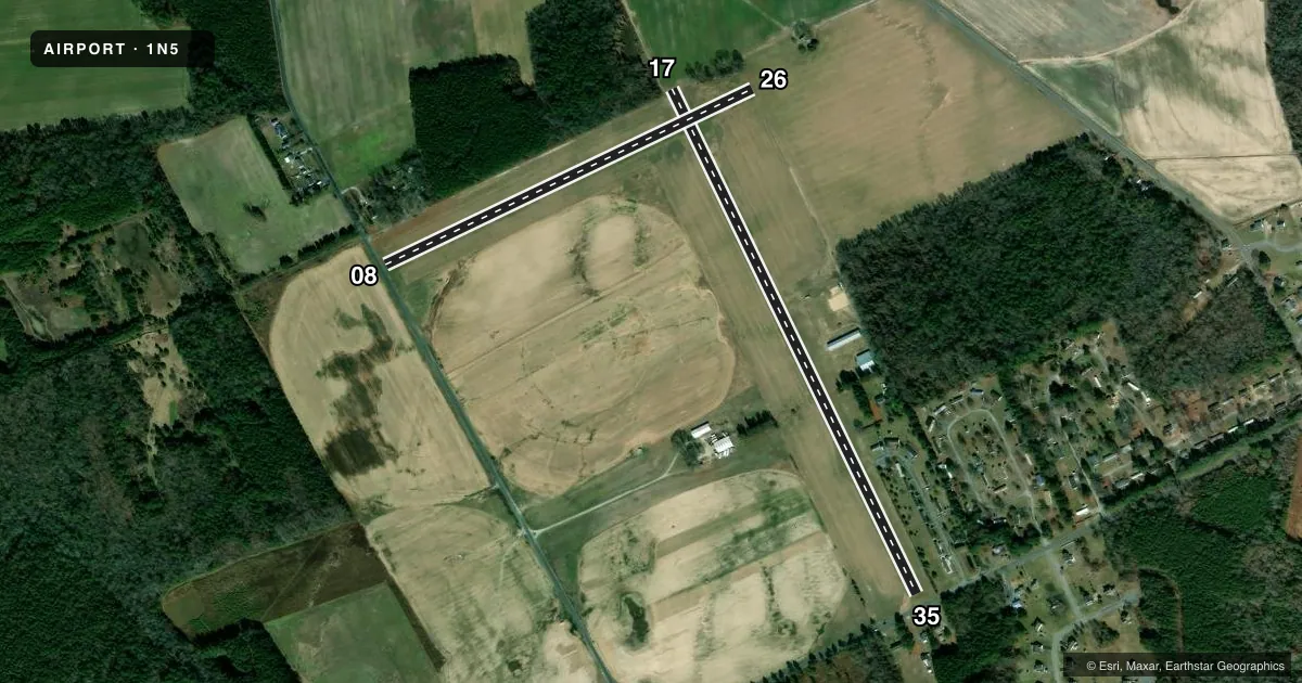
Runways & pattern
Full pagePattern entry · RWY 17
LEFT TRAFFIC| Runway | Heading (°M) | Length | Surface | Traffic |
|---|---|---|---|---|
| 17/35Favored | 144° / 324° | 3,171 ft | TURF | Standard L |
| 08/26 | 54° / 234° | 2,302 ft | TURF | Standard L |
Runway end performance
| End | TORA | TODA | ASDA | LDA | VGSI | Approach lights | Obstruction |
|---|---|---|---|---|---|---|---|
| 17 | — | — | — | — | PNIL(4°) | — | 60', trees, 607' from thr, 75' R of cntrln, slope 10 |
| 35 | — | — | — | — | PNIL(5°) | — | 15', road, 65' from thr, 0' R of cntrln, slope 4 |
| 08 | — | — | — | — | — | — | 15', road, 15' from thr, 0' R of cntrln, slope 1 |
| 26 | — | — | — | — | — | — | 31', trees, 340' from thr, 66' R of cntrln, slope 10 |
Declared distances in feet. TORA = takeoff run available, TODA = takeoff distance, ASDA = accelerate-stop, LDA = landing distance.
Airport sketch
Runways drawn to scale from FAA survey coordinates, rendered over satellite imagery. Not for navigation.
Approaches & charts
Services on the field
Fuel grades, oxygen, maintenance, ramp storage and lighting — as declared to the FAA by the airport operator.
Fuel & services
- Fuel
- Not available
- Other services
- AGRI
Ramp & ground
- Transient storage
- Tie-down
- Landing fee
- No fee published
- Lighting schedule
- SEE RMK
- Beacon schedule
- SEE RMK
- Beacon
- White / Green (civil land)(WG)
- Wind indicator
- Lighted
- Segmented circle
- No
Fuel & FBOs
Cheapest 100LL and Jet A on the field and nearby. Always confirm with the FBO before taxi.
Airport notes
Surface conditions, obstructions, local procedures, lighting outages and other notes published with each FAA cycle.
General notes
- ULTRALIGHT ACT ON & INVOF ARPT.
- +375 FT LGTD ANT 3200 FT L OF RWY 35 THR ON L DOWNWIND.
- BIRDS & WILDLIFE ON & INVOF ARPT.
- FOR CD CTC PATUXENT APCH AT 301-342-3740, WHEN PATUXENT APCH IS CLSD CTC POTOMAC APCH AT 866-640-4124.
- +70 FT TREES MID-POINT BOTH SIDES RY 17/35.
Lighting notes
- DUSK-2300. ACTVT BCN- CTAF.
- DUSK-2300. ACTVT LIRL RWY 17/35 - CTAF.
Runway surface & condition
- 17/35+60 FT TREES MID-POINT BOTH SIDES OF RWY.
Approach & departure obstructions
- 08DTHR MKD WITH 3 ORANGE CONES.
- 17THR & DTHR MKD WITH LGTS & CONES.
- 26DTHR MKD WITH 3 ORANGE CONES.
- 35THR & DTHR MKD WITH LGTS & CONES.
- 08APCH RATIO 20:1 TO DSPLCD THR.
- 17APCH RATIO 20:1 TO DSPLCD THR.
- 26APCH RATIO 20:1 TO DSPLCD THR.
- 35APCH RATIO 20:1 TO DSPLCD THR.
- 08+70 FT TREES L SIDE OF RWY 150 FT; 15 FT RD AT THR.
- 17300 FT LGTD ANT 1/2 MILE FM RWY 500 FT L OF EXTDD CNTRLN.
- 35+3 FT GND AT RWY END; 32 FT MKD PLINE; +15 FT RD 60 FT FM RWY END.
VFR map & nearby airports
VFR sectional. Tap any ICAO chip to open that airport.
Key facts · 1N5
Answer card- ICAO
- 1N5
- Name
- BENNETT
- Location
- SALISBURY, MARYLAND
- Elevation
- 46 ft MSL
- Traffic pattern altitude
- 1,046 ft MSL (1,000 AGL)
- Control tower
- Non-towered (use CTAF)
- Total runways
- 2
- Longest runway
- 17/35 · 3,171 ft
- Published ILS approaches
- 0
- Published frequencies
- 6
- Magnetic variation
- 10°
- Current flight rules
- MVFR
- Current wind
- 130° at 4 kt
- Favored runway now
- RWY 17
Bennett Airport (1N5) sits in Salisbury, Maryland. Field elevation is 46 ft MSL. It has two turf runways. The longest is runway 17/35 at 3,171 ft. There is no control tower. Pattern altitude is not published, so use 1,000 ft AGL for light piston operations unless the current Chart Supplement says otherwise.
No ILS approaches are published here. The field uses CTAF 122.8. UNICOM is also 122.8. For clearance delivery, Patuxent Approach is listed first. If Patuxent is closed, contact Potomac Approach. The airport sits in a low-elevation coastal area, so expect soft-field judgment to matter more than raw performance numbers. Watch the runway environment closely. Published remarks note a 300-foot lighted antenna about half a mile from the runway, left of the extended centerline for runway 17. There are also trees near runway 08 and obstructions near the end of runway 35.
No on-field FBOs are listed in the facts, so verify current fuel and services with the airport operator or the field directly before you go. Ultralight aircraft operate on and near the airport. The beacon runs from dusk to 2300. Low-intensity runway lights for 17/35 also run from dusk to 2300 and are activated on CTAF.