METAR & TAF W41
W41 does not publish a METAR.
Showing the nearest reporting station: KTGI (TANGIER ISLAND) · 14.1 NM away. Conditions at W41 may differ.
METAR · KTGI
Observed 07:35Z
KTGI 270735Z AUTO 16005KT 20/20 A3000 RMK AO1 T02030200
- Wind
- 160° @ 5 kt
- Visibility
- —
- Temp / Dew
- 20°C / 20°C
- Altimeter
- 30.00 inHg
- Clouds
- Clear
- Density alt
- 506 ft
- Ceiling
- Unlimited
- Rules
- VFR
Airport info & contacts
Manager on record, flight service, ARTCC, attendance schedule and pattern altitude — published by the FAA and refreshed every 28 days.
Location
- From city
- 3 NM NE
- VFR sectional
- WASHINGTON
- ARTCC
- ZDC · WASHINGTON
- NOTAM facility
- DCA (NOTAM-D)
Airport manager
- Name
- BRIAN FOWLER
- Phone
- 410-968-1333
- Address
- 319 MAIN STREET, CRISFIELD MD 21817
Flight service · Hours
- FSS DCA
- LEESBURG1-800-WX-BRIEF
- Attendance
- 0830-1630
Frequencies
Tap any row to copy the frequency to your clipboard.
Runways & pattern
Full pagePattern entry · RWY 14
LEFT TRAFFIC| Runway | Heading (°M) | Length | Surface | Traffic |
|---|---|---|---|---|
| 14/32Favored | 122° / 302° | 2,397 ft | ASPH | Standard L |
| 06/24 | 40° / 220° | 1,060 ft | TURF | Standard L |
Runway end performance
| End | TORA | TODA | ASDA | LDA | VGSI | Approach lights | Obstruction |
|---|---|---|---|---|---|---|---|
| 14 | — | — | — | — | PAPI 2-box left(3°) | — | — |
| 32 | — | — | — | — | PAPI 2-box left(3.25°) | — | 15', road, 515' from thr, 0' R of cntrln, slope 21 |
| 06 | — | — | — | — | — | — | 91', trees, 1410' from thr, 111' R of cntrln, slope 15 |
| 24 | — | — | — | — | — | — | 54', trees, 785' from thr, 181' R of cntrln, slope 14 |
Declared distances in feet. TORA = takeoff run available, TODA = takeoff distance, ASDA = accelerate-stop, LDA = landing distance.
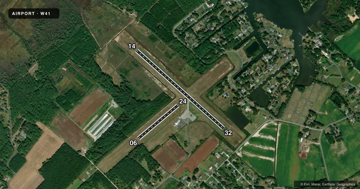
Airport sketch
Runways drawn to scale from FAA survey coordinates, rendered over satellite imagery. Not for navigation.
Approaches & charts
Services on the field
Fuel grades, oxygen, maintenance, ramp storage and lighting — as declared to the FAA by the airport operator.
Fuel & services
- Fuel
- 100LL
- Oxygen (bottled)
- Not available
- Oxygen (bulk)
- Not available
- Airframe repair
- Not available
- Power plant repair
- Not available
Ramp & ground
- Transient storage
- Tie-down
- Landing fee
- No fee published
- Customs
- Not available
- Lighting schedule
- SEE RMK
- Beacon schedule
- SS-SR
- Beacon
- White / Green (civil land)(WG)
- Wind indicator
- Lighted
- Segmented circle
- No
Fuel & FBOs
Cheapest 100LL and Jet A on the field and nearby. Always confirm with the FBO before taxi.
Airport notes
Surface conditions, obstructions, local procedures, lighting outages and other notes published with each FAA cycle.
General notes
- TURF AREAS OF ARPT MAY BE SOFT.
- BIRDS & WILDLIFE ON & INVOF ARPT.
- FOR CD CTC PATUXENT APCH AT 301-342-3740, WHEN PATUXENT APCH IS CLSD CTC POTOMAC APCH AT 866-640-4124.
Lighting notes
- DUSK-DAWN. ACTVT REIL RWY 14 & 32; MIRL RWY 14/32 - CTAF.
Runway surface & condition
- 06/24RWY 06/24 CLSD INDEFLY.
Other notes
- EXISTED PRIOR TO 1959.
VFR map & nearby airports
VFR sectional. Tap any ICAO chip to open that airport.
Key facts · W41
Answer card- ICAO
- W41
- Name
- CRISFIELD-SOMERSET COUNTY
- Location
- CRISFIELD, MARYLAND
- Elevation
- 4.1 ft MSL
- Traffic pattern altitude
- 1,004.1 ft MSL (1,000 AGL)
- Control tower
- Non-towered (use CTAF)
- Total runways
- 2
- Longest runway
- 14/32 · 2,397 ft
- Published ILS approaches
- 0
- Published frequencies
- 6
- Magnetic variation
- 10°
- Current flight rules
- VFR
- Current wind
- 160° at 5 kt
- Favored runway now
- RWY 14
Crisfield-Somerset County Airport sits in Crisfield, Maryland. Field elevation is 4.1 ft MSL. The airport has two runways. The longest is 14/32 at 2,397 ft on asphalt. Runway 06/24 is 1,060 ft on turf. Runway 06/24 is closed indefinitely, so plan on 14/32 for arrivals and departures. There is no control tower. CTAF and UNICOM are both 122.8. No ILS approaches are published.
Pattern altitude is not published. Use standard 1,000 ft AGL for light piston operations unless the current Chart Supplement says otherwise. Patuxent Approach handles clearance delivery. When Patuxent Approach is closed, contact Potomac Approach. The published remarks also note birds and wildlife on and near the field. Turf areas may be soft, so watch your rollout and taxi if you are using any grass surface.
The on-field FBO is Crisfield Municipal Airport. It carries 100LL. From dusk to dawn, runway end identifier lights are active on runways 14 and 32. Medium intensity runway lights are also on 14 and 32. They are controlled by CTAF. For a first-time arrival, the main things to plan for are the short runway environment, the low field elevation near the water and wildlife on the airport. Check the current Chart Supplement for any other local procedures before you go.