METAR & TAF KOXB
Current METAR
Observed 21:53Z
KOXB 262153Z AUTO 12005KT 10SM CLR 24/17 A2988 RMK AO2 SLP119 T02390167
- Wind
- 120° @ 5 kt
- Visibility
- 10 SM
- Temp / Dew
- 24°C / 17°C
- Altimeter
- 29.88 inHg
- Clouds
- CLR
- Density alt
- 1,149 ft
- Ceiling
- Unlimited
- Rules
- VFR
Airport info & contacts
Manager on record, flight service, ARTCC, attendance schedule and pattern altitude — published by the FAA and refreshed every 28 days.
Location
- From city
- 2 NM SW
- VFR sectional
- WASHINGTON
- ARTCC
- ZDC · WASHINGTON
- NOTAM facility
- OXB (NOTAM-D)
Airport manager
- Name
- JAIME GIANDOMENICO
- Phone
- (443) 235-4434
- Address
- 12724 AIRPORT RD, BERLIN MD 21811
Flight service · Hours
- FSS DCA
- LEESBURG1-800-WX-BRIEF
- Attendance
- 0800-1700
Frequencies
Tap any row to copy the frequency to your clipboard.
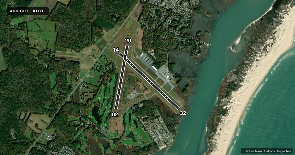
Runways & pattern
Full pagePattern entry · RWY 14
LEFT TRAFFIC| Runway | Heading (°M) | Length | Surface | Traffic |
|---|---|---|---|---|
| 14/32Favored | 121° / 301° | 4,074 ft | ASPH | Standard L |
| 02/20 | 358° / 178° | 3,204 ft | ASPH | Standard L |
Runway end performance
| End | TORA | TODA | ASDA | LDA | VGSI | Approach lights | Obstruction |
|---|---|---|---|---|---|---|---|
| 14 | — | — | — | — | PAPI 2-box left(4°) | — | 65', trees, 1329' from thr, 46' R of cntrln, slope 17 |
| 32 | — | — | — | — | PAPI 4-box left(3°) | — | — |
| 02 | — | — | — | — | PAPI 2-box left(3°) | — | — |
| 20 | — | — | — | — | PAPI 2-box left(4°) | — | — |
Declared distances in feet. TORA = takeoff run available, TODA = takeoff distance, ASDA = accelerate-stop, LDA = landing distance.
Airport sketch
Runways drawn to scale from FAA survey coordinates, rendered over satellite imagery. Not for navigation.
Approaches & charts
ILS · 1
Services on the field
Fuel grades, oxygen, maintenance, ramp storage and lighting — as declared to the FAA by the airport operator.
Fuel & services
- Fuel
- 100LLA
- Oxygen (bottled)
- Not available
- Oxygen (bulk)
- Not available
- Airframe repair
- Major
- Power plant repair
- Major
- Other services
- CHTR,INSTR,PAJA,RNTL,SALES,SURV
Ramp & ground
- Transient storage
- Tie-down
- Hangar
- Landing fee
- No fee published
- Customs
- Not available
- Lighting schedule
- SEE RMK
- Beacon schedule
- SS-SR
- Beacon
- White / Green (civil land)(WG)
- Wind indicator
- Lighted
- Segmented circle
- Yes
Fuel & FBOs
Cheapest 100LL and Jet A on the field and nearby. Always confirm with the FBO before taxi.
Airport notes
Surface conditions, obstructions, local procedures, lighting outages and other notes published with each FAA cycle.
General notes
- DEER & BIRDS ON & INVOF ARPT.
- TRUCKS AND VEHICLES CROSSING TWY, NORTH OF HOLD BLOCK RWY 02.
- FOR CD CTC PATUXENT APCH AT 301-342-3740, WHEN PATUXENT APCH IS CLSD CTC POTOMAC APCH AT 866-640-4124.
Lighting notes
- MIRL RWYS 02/20 & 14/32 OPR SS-SR AND PRESET LOW INTST; INCR INTST & ACTVT REIL RWY 02, 14, 20 & 32 - CTAF. PAPI RWY 02, 14, 20 & 32 OPR CONSLY.
Fuel notes
- 100LL24 HR SELF SERVE 100LL AVBL WITH CREDIT CARD.
Approach & departure obstructions
- 0240 FT TREES 177 FT 'L' OF RWY CNTRLN.
- 148 FT GRND/BRSH 180 FT 'R' OF RWY CNTRLN.
- 02PAPI UNUSBL BYD 6 DEG LEFT OF CNTRLN.
Other notes
- HNGR AVBL WITH PRIOR COORDINATION.
VFR map & nearby airports
VFR sectional. Tap any ICAO chip to open that airport.
Key facts · KOXB
Answer card- ICAO
- KOXB
- Name
- OCEAN CITY MUNI
- Location
- OCEAN CITY, MARYLAND
- Elevation
- 15.9 ft MSL
- Traffic pattern altitude
- 1,015.9 ft MSL (1,000 AGL)
- Control tower
- Non-towered (use CTAF)
- Total runways
- 2
- Longest runway
- 14/32 · 4,074 ft
- Published ILS approaches
- 1
- Published frequencies
- 8
- Magnetic variation
- 12°
- Current flight rules
- VFR
- Current wind
- 120° at 5 kt
- Favored runway now
- RWY 14
Ocean City Muni is in Ocean City, Maryland. Field elevation is 15.9 ft MSL. The airport has two asphalt runways. The longest is runway 14/32 at 4,074 ft. There is no control tower, so expect CTAF operations and coordinate closely with other traffic. Pattern altitude is not published. Use the standard 1,000 ft AGL pattern unless the current Chart Supplement says otherwise.
The field has one ILS approach to runway 32. That matters on a coastal field where weather can move in fast. The airport sits very low near sea level, so density altitude is usually not the main issue. Wind, traffic and runway selection often matter more. Published remarks also call out trees near runway 02. They also note brush near runway 14, plus deer and birds on or near the airport. Trucks and vehicles also cross the taxiway north of the hold short block for runway 02, so keep your head up on the ground.
Ocean City Municipal Airport is the on-field FBO. It carries 100LL and Jet A Prist. Twenty-four hour self-serve 100LL is available with credit card. REIL, PAPI and MIRL operate continuously. For clearance delivery, contact Patuxent Approach. If Patuxent is closed, use Potomac Approach. Hangar availability is by prior coordination.