METAR & TAF KSBY
Current METAR
Observed 12:54Z
KSBY 271254Z 14005KT 10SM BKN055 BKN070 22/20 A2988 RMK AO2 SLP119 T02170200
- Wind
- 140° @ 5 kt
- Visibility
- 10 SM
- Temp / Dew
- 22°C / 20°C
- Altimeter
- 29.88 inHg
- Clouds
- BKN
- Density alt
- 955 ft
- Ceiling
- 5,500 ft AGL
- Rules
- VFR
Airport info & contacts
Manager on record, flight service, ARTCC, attendance schedule and pattern altitude — published by the FAA and refreshed every 28 days.
Location
- From city
- 4 NM SE
- VFR sectional
- WASHINGTON
- ARTCC
- ZDC · WASHINGTON
- NOTAM facility
- SBY (NOTAM-D)
Airport manager
- Name
- ANTHONY RUDY
- Phone
- 410-548-4827
- Address
- 5485 AIRPORT TERMINAL RD, UNIT A, SALISBURY MD 21804
Flight service · Hours
- FSS DCA
- LEESBURG1-800-WX-BRIEF
- Attendance
- 0430-0030
Frequencies
Tap any row to copy the frequency to your clipboard.
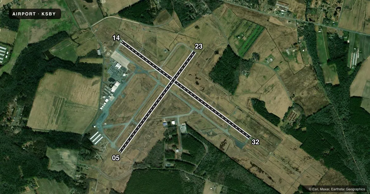
Runways & pattern
Full pagePattern entry · RWY 14
LEFT TRAFFIC| Runway | Heading (°M) | Length | Surface | Traffic |
|---|---|---|---|---|
| 14/32Favored | 115° / 295° | 6,400 ft | ASPH-CONC | Standard L |
| 05/23 | 25° / 205° | 5,000 ft | ASPH | Standard L |
Runway end performance
| End | TORA | TODA | ASDA | LDA | VGSI | Approach lights | Obstruction |
|---|---|---|---|---|---|---|---|
| 14 | 6,400' | 6,400' | 6,400' | 6,400' | PAPI 4-box left(3°) | — | — |
| 32 | 6,400' | 6,400' | 6,400' | 6,400' | PAPI 4-box left(3°) | MALSR | — |
| 05 | 5,000' | 5,000' | 5,000' | 5,000' | PAPI 4-box left(3°) | — | 95', tree, 2920' from thr, 190' R of cntrln, slope 28 |
| 23 | 5,000' | 5,000' | 5,000' | 5,000' | PAPI 4-box left(3°) | — | 95', tree, 2800' from thr, 0' R of cntrln, slope 27 |
Declared distances in feet. TORA = takeoff run available, TODA = takeoff distance, ASDA = accelerate-stop, LDA = landing distance.
Airport sketch
Runways drawn to scale from FAA survey coordinates, rendered over satellite imagery. Not for navigation.
Approaches & charts
ILS · 1
Services on the field
Fuel grades, oxygen, maintenance, ramp storage and lighting — as declared to the FAA by the airport operator.
Fuel & services
- Fuel
- 100LLA
- Oxygen (bottled)
- Not available
- Oxygen (bulk)
- Not available
- Airframe repair
- Major
- Power plant repair
- Major
- Other services
- CHTR,INSTR,RNTL,SALES
Ramp & ground
- Transient storage
- Tie-down
- Hangar
- Landing fee
- No fee published
- Customs
- Not available
- Lighting schedule
- SEE RMK
- Beacon schedule
- SS-SR
- Beacon
- White / Green (civil land)(WG)
- Wind indicator
- Lighted
- Segmented circle
- No
Fuel & FBOs
Cheapest 100LL and Jet A on the field and nearby. Always confirm with the FBO before taxi.
Airport notes
Surface conditions, obstructions, local procedures, lighting outages and other notes published with each FAA cycle.
General notes
- MIL TRNG ACT, DEER & BIRDS ON & INVOF ARPT.
- FBO HRS 0700-1900LCL. FOR SERVICES AFTER HRS CALL 410-749-0323.
- FOR CD CTC PATUXENT APCH AT 301-342-3740, WHEN PATUXENT APCH IS CLSD CTC POTOMAC APCH AT 866-640-4124.
- RWY 32 NSDT REFLECTIVE LNDG ZONE MKR PANELS ADJ TO RWY.
- TWY G SOUTH 950FT CLSD TO ACFT WINGSPAN MORE THAN 49 FT.
- RWY 5 NONSTD REFLECTIVE LDG ZONE MKR PANELS ADJ TO THE RWY.
- RWY 23 NONSTD REFLECTIVE LDG ZONE MKR PANELS ADJ TO THE RWY.
Lighting notes
- WHEN ATCT CLSD ACTVT MALSR RWY 32; REIL RWY 05, 14 & 23; MIRL RWY 05/23; HIRL RWY 14/32; TWY LGTS - CTAF. PAPI RWY 5, 14, 23 & 32 OPR CONSLY.
Runway surface & condition
- 05/23PCR VALUE: 130/F/C/X/T
- 14/32PCR VALUE: 400/F/D/X/T
Other notes
- PRIOR TO 1959.
- 24 HR PPR RQR FOR UNSKED ACR OPS CTC AMGR.
VFR map & nearby airports
VFR sectional. Tap any ICAO chip to open that airport.
Key facts · KSBY
Answer card- ICAO
- KSBY
- Name
- SALISBURY-OCEAN CITY WICOMICO RGNL
- Location
- SALISBURY, MARYLAND
- Elevation
- 52.5 ft MSL
- Traffic pattern altitude
- 1,052.5 ft MSL (1,000 AGL)
- Control tower
- Towered · 0600-2230
- Total runways
- 2
- Longest runway
- 14/32 · 6,400 ft
- Published ILS approaches
- 1
- Published frequencies
- 10
- Magnetic variation
- 12°
- Current flight rules
- VFR
- Current wind
- 140° at 5 kt
- Favored runway now
- RWY 14
KSBY sits in Salisbury, Maryland. Field elevation is 52.5 ft MSL. The airport has two runways. The longest is runway 14/32 at 6,400 ft. Runway 05/23 is 5,000 ft. The field has a control tower. Tower hours are 0600-2230 local.
One ILS approach is published for runway 32. Pattern altitude is not published in the facts. Use the standard 1,000 ft AGL unless the current Chart Supplement says otherwise. Azure Flight Support is on the field. It carries 100LL and Jet A. Call ahead at (410) 749-0323 for after-hours service. Published remarks also note that military training activity can be present. Deer and birds are reported on and near the airport. That matters here.
A few ramp and taxi details are worth planning for. Taxiway G south 950 ft is closed to aircraft with wingspan more than 49 ft. Taxiway E is closed to aircraft with wingspan more than 79 ft. For unscheduled operations, 24-hour prior permission is required. Contact the airport manager before arrival. When the tower is closed, runway 32 uses MALSR lighting. Runway 05, 14, 23 and 32 have PAPI that operate continuously. The airport is near the Maryland coast. Expect busy training traffic. Stay sharp on the pattern and taxi plan.