METAR & TAF KCGE
Current METAR
Observed 20:15Z
KCGE 262015Z AUTO VRB05KT 10SM CLR 28/16 A2986 RMK A01
- Wind
- VAR @ 5 kt
- Visibility
- 10 SM
- Temp / Dew
- 28°C / 16°C
- Altimeter
- 29.86 inHg
- Clouds
- CLR
- Density alt
- 1,659 ft
- Ceiling
- Unlimited
- Rules
- VFR
Airport info & contacts
Manager on record, flight service, ARTCC, attendance schedule and pattern altitude — published by the FAA and refreshed every 28 days.
Location
- From city
- 3 NM SE
- VFR sectional
- WASHINGTON
- ARTCC
- ZDC · WASHINGTON
- NOTAM facility
- DCA (NOTAM-D)
Airport manager
- Name
- STEVE NUWER
- Phone
- 410-228-4571
- Address
- 5263 BUCKTOWN RD, CAMBRIDGE MD 21613
Flight service · Hours
- FSS DCA
- LEESBURG1-800-WX-BRIEF
- Attendance
- 0800-1700
Frequencies
Tap any row to copy the frequency to your clipboard.
Runways & pattern
Full pagePattern entry · RWY 34
LEFT TRAFFICRunway end performance
| End | TORA | TODA | ASDA | LDA | VGSI | Approach lights | Obstruction |
|---|---|---|---|---|---|---|---|
| 16 | — | — | — | — | PAPI 2-box left(3.5°) | — | 60', trees, 1516' from thr, 240' R of cntrln, slope 21 |
| 34 | — | — | — | — | PAPI 2-box left(3.25°) | — | 15', road, 440' from thr, 250' R of cntrln, slope 16 |
Declared distances in feet. TORA = takeoff run available, TODA = takeoff distance, ASDA = accelerate-stop, LDA = landing distance.
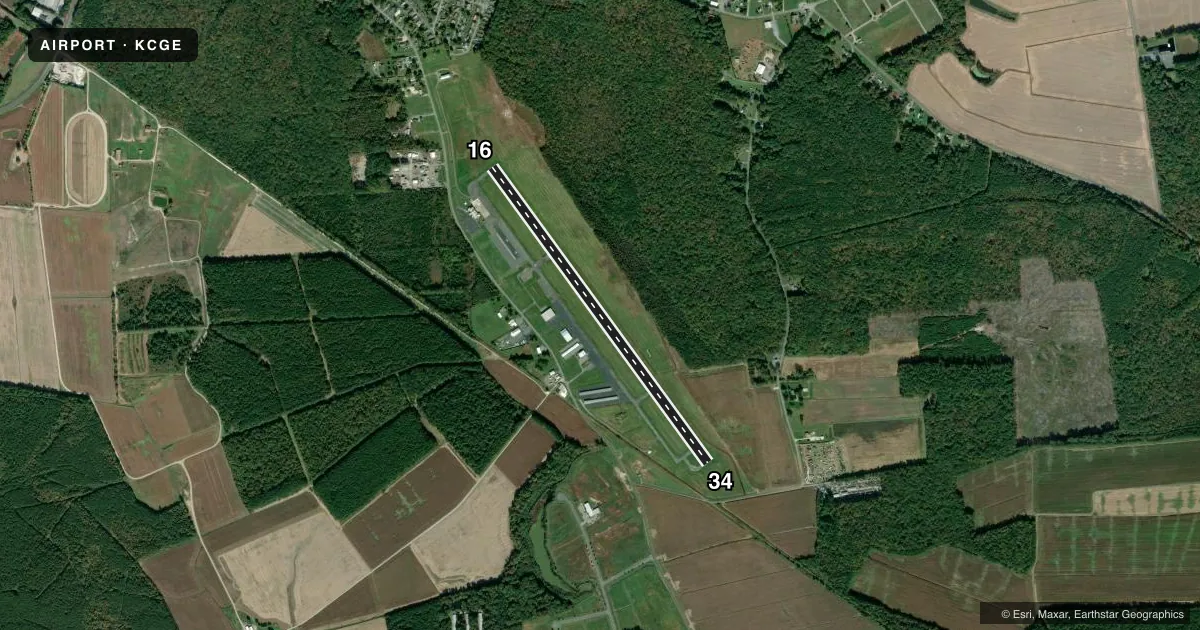
Airport sketch
Runways drawn to scale from FAA survey coordinates, rendered over satellite imagery. Not for navigation.
Approaches & charts
Services on the field
Fuel grades, oxygen, maintenance, ramp storage and lighting — as declared to the FAA by the airport operator.
Fuel & services
- Fuel
- 100LLA
- Airframe repair
- Not available
- Power plant repair
- Not available
- Other services
- AGRI,INSTR,RNTL,SALES
Ramp & ground
- Transient storage
- Tie-down
- Hangar
- Landing fee
- No fee published
- Lighting schedule
- SEE RMK
- Beacon schedule
- SS-SR
- Beacon
- White / Green (civil land)(WG)
- Wind indicator
- Lighted
- Segmented circle
- Yes
Fuel & FBOs
Cheapest 100LL and Jet A on the field and nearby. Always confirm with the FBO before taxi.
Airport notes
Surface conditions, obstructions, local procedures, lighting outages and other notes published with each FAA cycle.
General notes
- BIRDS AND/OR WILDLIFE ON AND INVOF ARPT.
- FOR CD CTC PATUXENT APCH AT 301-342-3740, WHEN PATUXENT APCH IS CLSD CTC POTOMAC APCH AT 866-640-4124.
Lighting notes
- ACTVT REIL RWY 16 & 34; PAPI RWY 16 & 34; MIRL RWY 16/34 - 121.9.
Other notes
- THIS AIRPORT HAS BEEN SURVEYED BY THE NATIONAL GEODETIC SURVEY.
- EXISTED PRIOR TO 1959.
- 1UNATNDD THANKSGIVING, CHRISTMAS & NEW YEARS DAY.
VFR map & nearby airports
VFR sectional. Tap any ICAO chip to open that airport.
Key facts · KCGE
Answer card- ICAO
- KCGE
- Name
- CAMBRIDGE-DORCHESTER RGNL
- Location
- CAMBRIDGE, MARYLAND
- Elevation
- 19.6 ft MSL
- Traffic pattern altitude
- 1,019.6 ft MSL (1,000 AGL)
- Control tower
- Non-towered (use CTAF)
- Total runways
- 1
- Longest runway
- 16/34 · 4,477 ft
- Published ILS approaches
- 0
- Published frequencies
- 6
- Magnetic variation
- 10°
- Current flight rules
- VFR
- Current wind
- 000° at 5 kt
- Favored runway now
- RWY 34
Cambridge-Dorchester Rgnl sits in Cambridge, Maryland. The field elevation is 19.6 ft MSL. It has one runway, 16/34, which is 4,477 ft long. There is no control tower. No ILS approaches are published here. The pattern altitude is not published, so use the standard 1,000 ft AGL for light piston traffic unless the current Chart Supplement says otherwise.
The on-field FBO is Cambridge-Dorchester Airport. It carries 100LL and Jet A. Call the FBO directly at (410) 228-4571 before arrival if you need current ramp or fuel status. Published remarks note runway end identifier lights, PAPI and medium intensity runway lighting on 16/34. The lighting frequency is 121.9. Patuxent Approach handles clearances. If Patuxent is closed, contact Potomac Approach. Birds and wildlife are reported on and near the airport. Keep a sharp scan on arrival and departure.
For a first-time visit, the main things to plan for are the low field elevation, the single asphalt runway and the lack of published ILS support. Check the current FAA Chart Supplement for any temporary changes. Verify local procedures with the airport operator or the FBO directly by phone before you go.