METAR & TAF 2W6
Current METAR
Observed 10:55Z
K2W6 271055Z AUTO VRB03KT OVC070 21/21 A2985 RMK AO2 T02080206 PWINO $
- Wind
- VAR @ 3 kt
- Visibility
- —
- Temp / Dew
- 21°C / 21°C
- Altimeter
- 29.85 inHg
- Clouds
- OVC
- Density alt
- 982 ft
- Ceiling
- 7,000 ft AGL
- Rules
- VFR
Airport info & contacts
Manager on record, flight service, ARTCC, attendance schedule and pattern altitude — published by the FAA and refreshed every 28 days.
Location
- From city
- 4 NM NE
- VFR sectional
- WASHINGTON
- ARTCC
- ZDC · WASHINGTON
- NOTAM facility
- DCA (NOTAM-D)
Airport manager
- Name
- ALLISON SWINT
- Phone
- 301-475-4200
- Address
- P.O. BOX 508, 44825 ST ANDREWS CHURCH ROAD, CALIFORNIA MD 20619
Flight service · Hours
- FSS DCA
- LEESBURG1-800-WX-BRIEF
- Attendance
- 0800-1700
Frequencies
Tap any row to copy the frequency to your clipboard.
Runways & pattern
Full pagePattern entry · RWY 29
LEFT TRAFFICRunway end performance
| End | TORA | TODA | ASDA | LDA | VGSI | Approach lights | Obstruction |
|---|---|---|---|---|---|---|---|
| 11 | — | — | — | — | PAPI 4-box left(3°) | — | — |
| 29 | — | — | — | — | PAPI 4-box left(3°) | — | — |
Declared distances in feet. TORA = takeoff run available, TODA = takeoff distance, ASDA = accelerate-stop, LDA = landing distance.
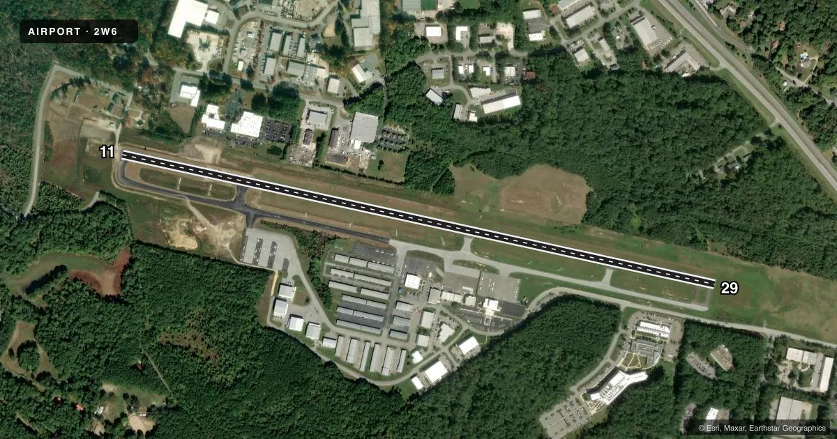
Airport sketch
Runways drawn to scale from FAA survey coordinates, rendered over satellite imagery. Not for navigation.
Approaches & charts
Services on the field
Fuel grades, oxygen, maintenance, ramp storage and lighting — as declared to the FAA by the airport operator.
Fuel & services
- Fuel
- 100LLA
- Oxygen (bottled)
- Not available
- Oxygen (bulk)
- Not available
- Airframe repair
- Major
- Power plant repair
- Major
- Other services
- AFRT,AMB,AVNCS,CHTR,INSTR,RNTL,SALES
Ramp & ground
- Transient storage
- Tie-down
- Landing fee
- No fee published
- Customs
- Not available
- Lighting schedule
- SEE RMK
- Beacon schedule
- SS-SR
- Beacon
- White / Green (civil land)(WG)
- Wind indicator
- Lighted
- Segmented circle
- Yes
Fuel & FBOs
Cheapest 100LL and Jet A on the field and nearby. Always confirm with the FBO before taxi.
Airport notes
Surface conditions, obstructions, local procedures, lighting outages and other notes published with each FAA cycle.
General notes
- DEER ON & INVOF RWY 11/29 SS-SR.
- GLDR, UAS, AND ULTRALIGHT ACTVT ON & INVOF ARPT.
- RWY 29 15 FT DEPRESSION (DOWNSLOPE) 300 FT FM THR 150 FT R-125 L.
- FOR CD CTC PATUXENT APCH AT 301-342-3740, WHEN PATUXENT APCH IS CLSD CTC POTOMAC APCH AT 866-640-4124.
- WHEN R-4007 IN EFFECT, ACFT OPRNG VFR AT ARPT MUST RMN WITHIN 1.5 NM OF ARPT, AT OR BLW 1500 FT MSL, AND ABV 700 FT AGL.
- ALL VFR FLT OPS CONDUCTED WI R-4007 SHALL BE AT OR BLW 1000 FT MSL. IFR AND VFR APCHS WI R-4007 WILL BE COORDD WITH PATUXENT APCH ON 121.0 OR BY PHONE 301-342-3740.
- MIL ACFT ON INSTR APCH TO PAX RIVER NAS MAY OVERFLY ARPT AT 1600 FT MSL & NOT MNT CTAF. WHEN PAX RWY 14 IN USE, 2W6 ACFT CROSS APCH PATH AT OR BLW 1000 FT OR ABOVE 3000 FT. MIL HELO OPS INVOF ARPT.
Lighting notes
- ACTVT REIL RWY 11 & 29; MIRL RWY 11/29 - CTAF. PAPI RWY 11 & 29 OPRS CONSLY.
Fuel notes
- 100LLSELF SERVE 100LL AVBL WITH CREDIT CARD.
Approach & departure obstructions
- 1130 FT TREES AT THLD, 160 FT L.
- 29FADED.
- 11PAPI UNUSBL BYD 6 DEGS LEFT OF CNTRLN.
Other notes
- MANAGERAIRPORT PHYSICAL ADDRESS IS 44200 AIRPORT ROAD, CALIFORNIA, MD 20619.
- MANAGEREXT 3511
- OWNEREXT 1321
- 11/29UNFILLED CRACKS, VEGETATIVE GROWTH, OXIDATION, RAVELLING.
VFR map & nearby airports
VFR sectional. Tap any ICAO chip to open that airport.
Key facts · 2W6
Answer card- ICAO
- 2W6
- Name
- ST MARY'S COUNTY RGNL
- Location
- LEONARDTOWN, MARYLAND
- Elevation
- 141.6 ft MSL
- Traffic pattern altitude
- 1,141.6 ft MSL (1,000 AGL)
- Control tower
- Non-towered (use CTAF)
- Total runways
- 1
- Longest runway
- 11/29 · 5,350 ft
- Published ILS approaches
- 0
- Published frequencies
- 6
- Magnetic variation
- 10°
- Current flight rules
- VFR
- Current wind
- 000° at 3 kt
- Favored runway now
- RWY 29
ST MARY'S COUNTY RGNL is in Leonardtown, Maryland. The field elevation is 141.6 ft MSL. It has one runway, 11/29, which is 5,350 ft long. There is no control tower. Pattern altitude is not published, so use the standard 1,000 ft AGL for light piston operations unless local procedures say otherwise.
No ILS approaches are published here. The airport sits near Patuxent River traffic, so expect military activity in the area. Published remarks note military aircraft may overfly the field on instrument approaches to Patuxent River NAS at 1,600 ft MSL. When Patuxent runway 14 is in use, traffic at 2W6 crosses the approach path at or below 1,000 ft MSL or above 3,000 ft MSL. Restricted area R-4007 also affects operations. VFR flight in the area may be limited to 1.5 NM of the airport, at or below 1,500 ft MSL and above 700 ft AGL when that restricted area is active. Runway 29 markings are faded. Runway 29 also has a 15 ft depression and a downslope near the threshold.
RCS Services is on the field. It carries 100LL and Jet A Prist. Self-serve 100LL is available with credit card. Runway lights and REIL on 11 and 29 are activated through CTAF. PAPI on both ends operates continuously. First-time pilots should brief the Patuxent frequencies before arrival. Stay alert for military helicopters in the vicinity.