METAR & TAF KANP
KANP does not publish a METAR.
Showing the nearest reporting station: KFME (FORT MEADE EXEC) · 12.4 NM away. Conditions at KANP may differ.
METAR · KFME
Observed 13:35Z
KFME 271335Z AUTO 00000KT 10SM CLR 25/20 A2988 RMK AO1
- Wind
- 000° @ 0 kt
- Visibility
- 10 SM
- Temp / Dew
- 25°C / 20°C
- Altimeter
- 29.88 inHg
- Clouds
- CLR
- Density alt
- 1,292 ft
- Ceiling
- Unlimited
- Rules
- VFR
Airport info & contacts
Manager on record, flight service, ARTCC, attendance schedule and pattern altitude — published by the FAA and refreshed every 28 days.
Location
- From city
- 5 NM SW
- VFR sectional
- WASHINGTON
- ARTCC
- ZDC · WASHINGTON
- NOTAM facility
- DCA (NOTAM-D)
Airport manager
- Name
- LEE RUNWAY MANAGER LLC
- Phone
- 410-956-1280
- Address
- P.O. BOX 2342, ANNAPOLIS MD 21401
Flight service · Hours
- FSS DCA
- LEESBURG1-800-WX-BRIEF
- Attendance
- 0800-1600
Frequencies
Tap any row to copy the frequency to your clipboard.
Runways & pattern
Full pagePattern entry · RWY 12
LEFT TRAFFICRunway end performance
| End | TORA | TODA | ASDA | LDA | VGSI | Approach lights | Obstruction |
|---|---|---|---|---|---|---|---|
| 12 | — | — | — | — | PAPI 2-box left(5.75°) | — | 105', trees, 1873' from thr, 32' R of cntrln, slope 15 |
| 30 | — | — | — | — | PAPI 2-box right(4.25°) | — | 63', trees, 803' from thr, 84' R of cntrln, slope 9 |
Declared distances in feet. TORA = takeoff run available, TODA = takeoff distance, ASDA = accelerate-stop, LDA = landing distance.
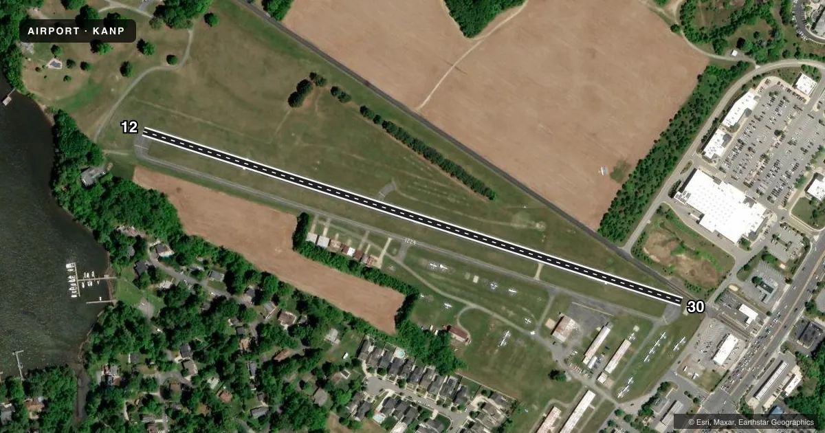
Airport sketch
Runways drawn to scale from FAA survey coordinates, rendered over satellite imagery. Not for navigation.
Approaches & charts
Services on the field
Fuel grades, oxygen, maintenance, ramp storage and lighting — as declared to the FAA by the airport operator.
Fuel & services
- Fuel
- 100LL
- Airframe repair
- Major
- Power plant repair
- Major
- Other services
- INSTR,RNTL
Ramp & ground
- Transient storage
- Tie-down
- Landing fee
- Yes
- Customs
- Not available
- Lighting schedule
- SEE RMK
- Beacon schedule
- SEE RMK
- Beacon
- White / Green (civil land)(WG)
- Wind indicator
- Lighted
- Segmented circle
- No
Fuel & FBOs
Cheapest 100LL and Jet A on the field and nearby. Always confirm with the FBO before taxi.
Airport notes
Surface conditions, obstructions, local procedures, lighting outages and other notes published with each FAA cycle.
General notes
- NO LANDING ON GRASS. LDG FEE AFTER ONE HOUR OR OVERNIGHT.
- TOUCH & GO OPNS PROHIBITED.
- NO TAKE-OFFS AFTER 2200 DAILY.
- NO GRASS CROSSOVER FM RWY 12/30 TO TWY ROLLOUT TO THE END OF RWY.
- HVY BIRD AND WILDLIFE ACT ON AND INVOF ARPT.
- ARPT CLSD 2200-0700 LCL, CTC ARPT MANAGER FOR DETAILS.
- FOR CD CTC POTOMAC APCH AT 866-429-5882.
Lighting notes
- DUSK-2200.
- ACTVT LIRL RWY 12/30 - CTAF. LIGHTING INOP BTW 2200-0700.
Approach & departure obstructions
- 126 FT FENCE ACROSS APCH END MARKED. 10 FT ROAD 156 FT FM THLD.
- 30+6 FT FENCE ACROSS APCH END MKD. +15 FT PUBLIC ROAD AT THLD, R OF CNTRLN.
- 12VGSI APCHS TO BE FLOWN. RWY 12 VGSI RELIABLE ON CNTLRN ONLY.
- 12RWY 12 APCH RATIO 20:1 TO DSPLCD THR & CNTRLN.
- 30RWY 30 APCH RATIO 20:1 TO THE DSPLCD THR AND CNTRLN.
Other notes
- EXISTED PRIOR TO 1959.
- 1CONTACT AIRPORT MANAGER 410-956-1280 FOR APPROVAL OF ANY FLIGHT OPERATIONS BETWEEN 2200 - 0700 LOCAL. ARPT UNATNDD NEW YEARS; MEMORIAL DAY; JULY 4; LABOR DAY; THANKSGIVING & CHRISTMAS.
- OWNERCORPORATION ESTABLISHED BY MARY C. LEE
- 12/30MINOR PAVEMENT CRACKS FULL LENGTH.
VFR map & nearby airports
VFR sectional. Tap any ICAO chip to open that airport.
Key facts · KANP
Answer card- ICAO
- KANP
- Name
- LEE
- Location
- ANNAPOLIS, MARYLAND
- Elevation
- 34.2 ft MSL
- Traffic pattern altitude
- 1,034.2 ft MSL (1,000 AGL)
- Control tower
- Non-towered (use CTAF)
- Total runways
- 1
- Longest runway
- 12/30 · 2,505 ft
- Published ILS approaches
- 0
- Published frequencies
- 3
- Magnetic variation
- 10°
- Current flight rules
- VFR
- Current wind
- 000° at 0 kt
- Favored runway now
- –
LEE Airport (KANP) sits in Annapolis, Maryland. Field elevation is 34.2 ft MSL. It has one runway, 12/30, which is 2,505 ft long. There is no control tower. Potomac Approach handles the area on 119.7 and 290.475. No ILS approaches are published here.
Pattern altitude is not published. Use the standard 1,000 ft AGL pattern for light piston traffic unless the current FAA Chart Supplement or ATC gives you something different. Lee Runway Manager is on field. It carries 100LL. Call (410) 956-1280 for current service details.
A few operational items matter here. Touch-and-go operations are prohibited. Visual glide slope indicators must be flown. The runway 12 VASI is reliable on the centerline only. Runway 30 has published obstacle clearance notes on approach. There is also a fence near the runway 12 approach end and a road close in. Heavy bird and wildlife activity is reported on and near the airport. Night operations need a call to the airport manager for approval between 2200 and 0700 local. Runway lighting is CTAF-activated. It is inoperative between 2200 and 0700. For a first-time arrival, brief the short runway, the wildlife and the published lighting limits before you go.