METAR & TAF KCGS
Current METAR
Observed 07:15Z
KCGS 270715Z AUTO 00000KT 10SM BKN075 BKN085 23/20 A2984 RMK AO2 T02330199
- Wind
- 000° @ 0 kt
- Visibility
- 10 SM
- Temp / Dew
- 23°C / 20°C
- Altimeter
- 29.84 inHg
- Clouds
- BKN
- Density alt
- 1,120 ft
- Ceiling
- 7,500 ft AGL
- Rules
- VFR
Airport info & contacts
Manager on record, flight service, ARTCC, attendance schedule and pattern altitude — published by the FAA and refreshed every 28 days.
Location
- From city
- 1 NM SE
- VFR sectional
- WASHINGTON
- ARTCC
- ZDC · WASHINGTON
- NOTAM facility
- CGS (NOTAM-D)
Airport manager
- Name
- DREW MYERS
- Phone
- 301-864-5844
- Address
- 1909 CORPORAL FRANK SCOTT DRIVE, COLLEGE PARK MD 20740
Flight service · Hours
- FSS DCA
- LEESBURG1-800-WX-BRIEF
- Attendance
- 0700-2200
Frequencies
Tap any row to copy the frequency to your clipboard.
Runways & pattern
Full pagePattern entry · RWY 15
LEFT TRAFFICRunway end performance
| End | TORA | TODA | ASDA | LDA | VGSI | Approach lights | Obstruction |
|---|---|---|---|---|---|---|---|
| 15 | 2,980' | 2,980' | 2,740' | 2,176' | PAPI 2-box left(4°) | — | 32', trees, 322' from thr, 51' R of cntrln, slope 3 |
| 33 | 2,980' | 2,980' | 2,846' | 2,675' | PAPI 2-box right(4°) | — | 64', trees, 1086' from thr, 172' R of cntrln, slope 13 |
Declared distances in feet. TORA = takeoff run available, TODA = takeoff distance, ASDA = accelerate-stop, LDA = landing distance.
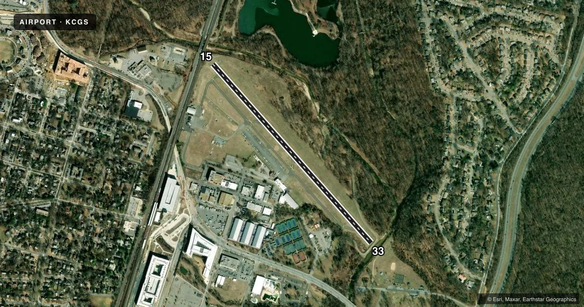
Airport sketch
Runways drawn to scale from FAA survey coordinates, rendered over satellite imagery. Not for navigation.
Approaches & charts
Services on the field
Fuel grades, oxygen, maintenance, ramp storage and lighting — as declared to the FAA by the airport operator.
Fuel & services
- Fuel
- 100LLA1+
- Oxygen (bottled)
- Not available
- Oxygen (bulk)
- Not available
- Airframe repair
- Not available
- Power plant repair
- Not available
Ramp & ground
- Transient storage
- Tie-down
- Landing fee
- No fee published
- Customs
- Not available
- Lighting schedule
- SEE RMK
- Beacon schedule
- SS-SR
- Beacon
- White / Green (civil land)(WG)
- Wind indicator
- Lighted
- Segmented circle
- Yes
Fuel & FBOs
Cheapest 100LL and Jet A on the field and nearby. Always confirm with the FBO before taxi.
Airport notes
Surface conditions, obstructions, local procedures, lighting outages and other notes published with each FAA cycle.
General notes
- NO TKOFS 2200-0700; LNDG ONLY.
- NO ACFT OVR 12500 LBS MFR GWT; HELS ONLY WITH 24 HR PPR - CALL AMGR 301-864-5844.
- NOISE ABATEMENT PROCEDURES IN EFFECT CTC AMGR 301-864-5844.
- AER 15 HEAVY SMOKE & FIREFIGHTING TRAINING OPNS INTERMITTENTLY IN PROGRESS.
- NO STUDENT TGL OR SOLO OPNS PERMITTED.
- DEER AND OTHER WILDLIFE ON & INVOF ARPT.
- COMPLIANCE WITH 14CFR SECTION 93.335 IS REQUIRED BEFORE PILOTS MAY OPERATE TO/FROM THIS AIRPORT.
- FOR CD CTC POTOMAC APCH AT 866-599-3874.
- TSNT PRKG: FIRST 4 HRS FREE; FEE AFT, WAIVED W/MIN FUEL PURCHASE; OVNGT FEE.
- HEL RAMP FEE; WAIVED IF UNDER 3500 LBS OR MIN FUEL PURCHASE.
- ACFT HANDLING FEE IF RELOCATION TO/FROM FUEL AREA RQRD BY ARPT PSNL.
- BLDG 0.1 NM S OF ARPT 23 FT AGL LGTD.
Lighting notes
- ACTVT REIL RWY 15 & 33; PAPI RWY 15 & 33; MIRL RWY 15/33 - CTAF.
Approach & departure obstructions
- 15+33 FT RAILROAD, 117 FM THR WITH OBS LTS.
- 33+15 FT FENCE 87 FT R AT THR; -6 FT DITCH 65 FT L AT THR.
- 15APCH SLOPE AT CL 20:1 FM DSPLCD THR AND CENTERLINE.
Other notes
- EXISTED PRIOR TO 1959.
- OWNERTHE MARYLAND NATIONAL CAPITAL PARK & PLANNING CMSN.
VFR map & nearby airports
VFR sectional. Tap any ICAO chip to open that airport.
Key facts · KCGS
Answer card- ICAO
- KCGS
- Name
- COLLEGE PARK
- Location
- COLLEGE PARK, MARYLAND
- Elevation
- 48.9 ft MSL
- Traffic pattern altitude
- 1,048.9 ft MSL (1,000 AGL)
- Control tower
- Non-towered (use CTAF)
- Total runways
- 1
- Longest runway
- 15/33 · 2,980 ft
- Published ILS approaches
- 0
- Published frequencies
- 6
- Magnetic variation
- 11°
- Current flight rules
- VFR
- Current wind
- 000° at 0 kt
- Favored runway now
- –
College Park Airport sits in College Park, Maryland. Field elevation is 48.9 ft MSL. The airport has one runway, 15/33, which is 2,980 ft long. It is a non-towered field. Use CTAF 122.975 for local traffic. No ILS approaches are published here.
Pattern altitude is not published. For light piston traffic, plan on the standard 1,000 ft AGL pattern unless the current Chart Supplement or local procedures say otherwise. The on-field FBO is College Park Airport. It carries 100LL and Jet A with Prist. Call (301) 864-5844 for current service details.
This field has a few operational points worth checking before you go. No takeoffs are permitted between 2200 and 0700. Landings are allowed during those hours. Deer and other wildlife are reported on and near the airport. Runway 15 has a displaced-threshold approach slope note. Runway 33 has a fence right of the threshold area plus a ditch left of the threshold. Runway 15/33 has medium intensity lights, runway end identifier lights and PAPI. Potomac Approach handles clearance delivery. Heavy smoke and firefighting training operations can be active nearby. Student touch-and-go and solo operations are not permitted.