METAR & TAF KDCA
Current METAR
Observed 09:52Z
KDCA 270952Z 21005KT 10SM SCT065 BKN250 22/19 A2984 RMK AO2 SLP103 T02220189
- Wind
- 210° @ 5 kt
- Visibility
- 10 SM
- Temp / Dew
- 22°C / 19°C
- Altimeter
- 29.84 inHg
- Clouds
- BKN
- Density alt
- 957 ft
- Ceiling
- 25,000 ft AGL
- Rules
- VFR
Airport info & contacts
Manager on record, flight service, ARTCC, attendance schedule and pattern altitude — published by the FAA and refreshed every 28 days.
Location
- From city
- 3 NM S
- VFR sectional
- WASHINGTON
- ARTCC
- ZDC · WASHINGTON
- NOTAM facility
- DCA (NOTAM-D)
Airport manager
- Name
- TERRY LIERCKE
- Phone
- 703-417-8050
- Address
- 1 AVIATION CIRCLE, WASHINGTON DC 20001-6000
Flight service · Hours
- FSS DCA
- LEESBURG1-800-WX-BRIEF
- Attendance
- ALL
Frequencies
Tap any row to copy the frequency to your clipboard.
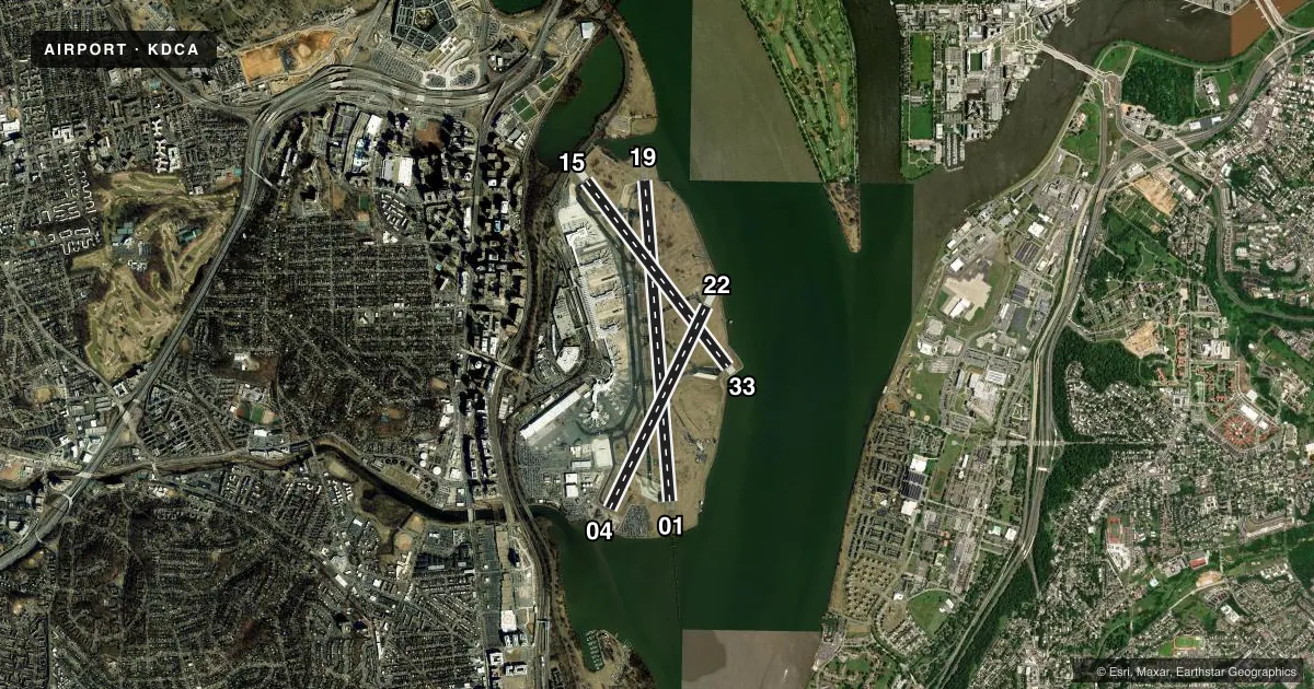
Runways & pattern
Full pagePattern entry · RWY 22
RIGHT TRAFFIC| Runway | Heading (°M) | Length | Surface | Traffic |
|---|---|---|---|---|
| 01/19 | 345° / 164° | 7,169 ft | ASPH | 19 R |
| 15/33 | 132° / 312° | 5,204 ft | ASPH | 15 R |
| 04/22Favored | 15° / 195° | 5,000 ft | ASPH | 22 R |
Runway end performance
| End | TORA | TODA | ASDA | LDA | VGSI | Approach lights | Obstruction |
|---|---|---|---|---|---|---|---|
| 01 | 6,869' | 6,869' | 6,869' | 6,869' | PAPI 4-box right(3°) | ALSF2 | 180', tower, 7700' from thr, 1600' R of cntrln, slope 41 |
| 19 | 6,869' | 6,869' | 6,869' | 6,869' | PAPI 4-box left(3°) | MALSF | 27', tree, 990' from thr, 240' R of cntrln, slope 29 |
| 15 | 5,204' | 5,204' | 5,204' | 5,204' | PAPI 4-box left(3°) | — | 49', trees, 380' from thr, 510' R of cntrln, slope 3 |
| 33 | 5,204' | 5,204' | 5,204' | 5,204' | PAPI 4-box left(3°) | — | 253', trees, 9600' from thr, 0' R of cntrln, slope 37 |
| 04 | 5,000' | 5,000' | 5,000' | 4,800' | PAPI 4-box left(3.25°) | — | 10', road, 400' from thr, 500' R of cntrln, slope 20 |
| 22 | 4,540' | 4,540' | 4,400' | 4,400' | PAPI 4-box left(3°) | — | 2', gnd, 220' from thr, 0' R of cntrln, slope 10 |
Declared distances in feet. TORA = takeoff run available, TODA = takeoff distance, ASDA = accelerate-stop, LDA = landing distance.
Airport sketch
Runways drawn to scale from FAA survey coordinates, rendered over satellite imagery. Not for navigation.
Approaches & charts
ILS · 2
Services on the field
Fuel grades, oxygen, maintenance, ramp storage and lighting — as declared to the FAA by the airport operator.
Fuel & services
- Fuel
- A
- Oxygen (bottled)
- Not available
- Oxygen (bulk)
- Not available
- Airframe repair
- Minor
- Power plant repair
- Minor
- Other services
- CARGO
Ramp & ground
- Transient storage
- Tie-down
- Hangar
- Landing fee
- Yes
- Customs
- Not available
- Beacon schedule
- SS-SR
- Beacon
- White / Green (civil land)(WG)
- Wind indicator
- Lighted
- Segmented circle
- No
Fuel & FBOs
Cheapest 100LL and Jet A on the field and nearby. Always confirm with the FBO before taxi.
Airport notes
Surface conditions, obstructions, local procedures, lighting outages and other notes published with each FAA cycle.
General notes
- LGT FM VEHICLE PARKING LOT LCTD 1000 FT SW OF RWY 01 COULD GIVE FALSE INDICATIONS OF BEING PART OF RWY 01 APCH LGT SYS DRG PERIODS OF REDUCED VIS & LOW CEILINGS.
- FORM 150R CREDIT CARD FOR ALL RQRD SVCS. NO MIL FACS.
- TWY K ENDS AT GATE 5.
- FLOCKS OF BIRDS ON & INVOF ARPT; FQT GULL & GEESE & DUCK POPULATIONS AB OVER ADJ RIVER AREAS.
- TRNG FLIGHTS THAT INCLUDE MULTIPLE APCHS AND/OR TOUCH & GO OPNS REQUIRE PRIOR PERMISSION FM THE ARPT MGR.
- LEFT-HAND TURN-OFFS FROM RWY 33 TO TWY 'K' PROHIBITED.
- ACFT ARRIVING/DEPARTING THE GA PARKING AREA ARE PROHIBITED FM TAXING BTN ACR PUSHBACK OPNS & THE GATES.
- BE ADVISED SOME AIRCREWS MISTAKE RWY 15 FOR RWY 19.
- RONALD REAGAN WASHINGTON NATIONAL ARPRT (KDCA) IS AN EMERGENCY USE ONLY FIELD FOR ALL DOD OWNED AND OPERATED ACFT.
- TWY N BTN APCH END RWY 15 AND TWY K CLSD TO ACFT WINGSPAN MORE THAN 124FT.
Runway surface & condition
- 01/19PCR VALUE: 580/F/B/W/T
- 04/22PCR VALUE: 420/F/B/W/T
- 15/33PCR VALUE: 540/F/B/W/T
- 19XTHIS RWY EXISTS TO SUPPORT THE DCA LDA ASSOCIATED WITH THE ILS.
Approach & departure obstructions
- 15RWY 15 +8 FT BLAST FENCE 120 FT FM AER 250 FT RIGHT.
- 19+10 FT BLDG (L/M) +120 FT FROM AER 300 FT LEFT.
- 19RWY 19 PAPI-4L CONSISTS OF TWO PAPI-4L SYSTEMS. RWY 19 PAPI-4L IS ROTATED 21 DEGS TO RIGHT OF CNTRLN. THE ROTATED PAPI-4L SYSTEM SUPPORTS VISUAL AND INSTR APCHS TO RWY 19. ADZY, ACFT ON TWY CREATE TMPRY OBSTN TO PAPI-4L.
- 04THREE OBSTRUCTION LGTS POLES--ONE 600 FEET LEFT, ONE ON CENTERLINE, ONE 600 FEET RIGHT.
Arresting gear
- 04_EMASENGINEERED MATERIALS ARRESTING SYSTEM (EMAS) 336 FT IN LENGTH BY 170 FT IN WIDTH LCTD AT THE DER 04.
- 15_EMASENGINEERED MATERIALS ARRESTING SYSTEM (EMAS) 142 FT IN LENGTH BY 170 FT IN WIDTH LCTD AT THE DER 15.
- 33_EMASENGINEERED MATERIALS ARRESTING SYSTEM (EMAS) 332 FT IN LENGTH BY 170 FT IN WIDTH LCTD AT THE DER 33.
Other notes
- RWY 06 +53 FT TREES 175 FT R @ THR.
VFR map & nearby airports
VFR sectional. Tap any ICAO chip to open that airport.
Key facts · KDCA
Answer card- ICAO
- KDCA
- Name
- RONALD REAGAN WASHINGTON NTL
- Location
- WASHINGTON, DIST. OF COLUMBIA
- Elevation
- 14.1 ft MSL
- Traffic pattern altitude
- 1,014.1 ft MSL (1,000 AGL)
- Control tower
- Towered · 24
- Total runways
- 3
- Longest runway
- 01/19 · 7,169 ft
- Published ILS approaches
- 2
- Published frequencies
- 22
- Magnetic variation
- 11°
- Current flight rules
- VFR
- Current wind
- 210° at 5 kt
- Favored runway now
- RWY 22
Ronald Reagan Washington Ntl sits in Washington, District of Columbia. Field elevation is 14.1 ft MSL. The airport has three asphalt runways. The longest is 7,169 ft. The tower is open 24 hours. Three ILS approaches are published for runway ends 01, 19 and 19X. Pattern altitude is not published. Use 1,000 ft AGL for light piston traffic unless current local guidance says otherwise.
Signature Aviation is on the field. It carries JET_A. Call (703) 417-3500 for current service details before arrival. This is a busy controlled field near the river. Bird activity is a real factor here. The Chart Supplement notes frequent gull, goose and duck traffic over adjacent river areas. There are also published cautions about confusing runway 15 with runway 19. Another remark warns that lights from the parking lot southwest of runway 01 can look like approach lighting in low visibility.
Taxi and runway awareness matter here. Runway 15/33, 04/22 and 01/19 all have asphalt surfaces. The airport also has published pavement strength data. Check the current FAA Chart Supplement for any local operating limits, taxi restrictions, or noise items before you go. If you are new to the field, brief the runway layout carefully and expect a busy environment.