METAR & TAF KFME
Current METAR
Observed 12:35Z
KFME 271235Z AUTO 00000KT 10SM CLR 21/20 A2989 RMK AO1
- Wind
- 000° @ 0 kt
- Visibility
- 10 SM
- Temp / Dew
- 21°C / 20°C
- Altimeter
- 29.89 inHg
- Clouds
- CLR
- Density alt
- 943 ft
- Ceiling
- Unlimited
- Rules
- VFR
Airport info & contacts
Manager on record, flight service, ARTCC, attendance schedule and pattern altitude — published by the FAA and refreshed every 28 days.
Location
- From city
- 1 NM SW
- VFR sectional
- WASHINGTON
- Pattern altitude
- 850 ft AGL · 1,000 ft MSL
- ARTCC
- ZDC · WASHINGTON
- NOTAM facility
- FME (NOTAM-D)
Airport manager
- Name
- MICHAEL A WASSEL
- Phone
- 410-222-6815
- Address
- 7515 GENERAL AVIATION DRIVE, SUITE 1, FT. MEADE MD 20755
Flight service · Hours
- FSS DCA
- LEESBURG1-800-WX-BRIEF
- Attendance
- 0830-1800
Frequencies
Tap any row to copy the frequency to your clipboard.
Runways & pattern
Full pagePattern entry · RWY 10
RIGHT TRAFFICRunway end performance
| End | TORA | TODA | ASDA | LDA | VGSI | Approach lights | Obstruction |
|---|---|---|---|---|---|---|---|
| 10 | — | — | — | — | PAPI 2-box left(4°) | — | 60', trees, 1227' from thr, 128' R of cntrln, slope 17 |
| 28 | — | — | — | — | PAPI 2-box left(4°) | — | — |
Declared distances in feet. TORA = takeoff run available, TODA = takeoff distance, ASDA = accelerate-stop, LDA = landing distance.
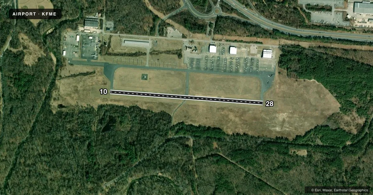
Airport sketch
Runways drawn to scale from FAA survey coordinates, rendered over satellite imagery. Not for navigation.
Approaches & charts
Services on the field
Fuel grades, oxygen, maintenance, ramp storage and lighting — as declared to the FAA by the airport operator.
Fuel & services
- Fuel
- 100LLA+
- Airframe repair
- Minor
- Power plant repair
- Minor
- Other services
- CHTR,INSTR,RNTL
Ramp & ground
- Transient storage
- Tie-down
- Landing fee
- No fee published
- Customs
- Not available
- Lighting schedule
- SEE RMK
- Beacon schedule
- SS-SR
- Beacon
- White / Green (civil land)(WG)
- Wind indicator
- Lighted
- Segmented circle
- Yes
Fuel & FBOs
Cheapest 100LL and Jet A on the field and nearby. Always confirm with the FBO before taxi.
Airport notes
Surface conditions, obstructions, local procedures, lighting outages and other notes published with each FAA cycle.
General notes
- DEER ON RWY & TWY.
- BE ALERT FOR NMRS BWI TBJT ARR/DEP IN THE AREA. FLY TFC PATTERN SOUTH OF THE FIELD TO AVOID BWI CLASS B ASP. REMAIN CLEAR OF BWI CLASS B ASP UNTIL CLNC IS OBTAINED.
- PAEW ADJ ALL TWYS AND RWYS 10 & 28 INDEFLY.
- FOR CD CTC POTOMAC APCH AT 866-429-5882.
- RWY 10 & 28 REIL; MIRL RWY 10/28 ON PHOTOCELL DURING DALGT HRS.
- RWY 28 NOISE ABATEMENT PROC: OBSTS CLRD, FLY UPWIND TRK OF 265 DEGS TIL CLRNG TOWNHOMES.
Lighting notes
- ACTVT REIL RWY 10 & 28; PAPI RWY 10 & 28; MIRL RWY 10/28 - CTAF.
Fuel notes
- 100LL24 HR SELF SVC 100LL AVBL WITH CREDIT CARD.
- A+24 HR SELF SVC JET A+ AVBL WITH CREDIT CARD.
Approach & departure obstructions
- 10PAPI UNUSBL BYD 8 DEGS LEFT & RIGHT OF CRS.
- 28PAPI UNUSBL BYD 5 DEGS LEFT OF CRS (TREES), AND 8 DEGS RIGHT OF CRS.
VFR map & nearby airports
VFR sectional. Tap any ICAO chip to open that airport.
Key facts · KFME
Answer card- ICAO
- KFME
- Name
- FORT MEADE EXEC
- Location
- FORT MEADE (ODENTON), MARYLAND
- Elevation
- 149.5 ft MSL
- Traffic pattern altitude
- 999.5 ft MSL (850 AGL)
- Control tower
- Non-towered (use CTAF)
- Total runways
- 1
- Longest runway
- 10/28 · 3,000 ft
- Published ILS approaches
- 0
- Published frequencies
- 4
- Magnetic variation
- 10°
- Current flight rules
- VFR
- Current wind
- 000° at 0 kt
- Favored runway now
- –
Fort Meade Exec sits in Fort Meade near Odenton, Maryland. Field elevation is 149.5 ft MSL. The airport has one runway. Runway 10/28 is 3,000 ft long with asphalt pavement. There is no control tower. Pattern altitude is 850 ft AGL, which is 999.5 ft MSL.
No ILS approaches are published here. For clearance delivery, Potomac Approach is listed in the remarks. The field is close to busy Baltimore and Washington traffic flows. Keep an eye out for arrivals and departures from Baltimore/Washington International Thurgood Marshall Airport. Fly the pattern south of the field to stay clear of Baltimore/Washington Class B airspace until you have clearance.
Tipton Airport Authority is on the field. It carries 100LL and Jet A+ fuel. Twenty-four hour self-serve fuel is available with credit card. Runway 10/28 has runway end identifier lights. Medium intensity runway lights are controlled by CTAF. The PAPI is installed on both ends. On runway 28, the published notes say the PAPI is unusable beyond 5 degrees left of course due to trees and 8 degrees right of course. Deer are also reported on the runways and taxiways, so a careful taxi and takeoff scan matters here.