METAR & TAF W00
W00 does not publish a METAR.
Showing the nearest reporting station: KCGS (COLLEGE PARK) · 7.4 NM away. Conditions at W00 may differ.
METAR · KCGS
Observed 12:35Z
KCGS 271235Z AUTO 30006KT 10SM CLR 25/20 A2986 RMK AO2 T02520197
- Wind
- 300° @ 6 kt
- Visibility
- 10 SM
- Temp / Dew
- 25°C / 20°C
- Altimeter
- 29.86 inHg
- Clouds
- CLR
- Density alt
- 1,483 ft
- Ceiling
- Unlimited
- Rules
- VFR
Airport info & contacts
Manager on record, flight service, ARTCC, attendance schedule and pattern altitude — published by the FAA and refreshed every 28 days.
Location
- From city
- 2 NM NW
- VFR sectional
- WASHINGTON
- ARTCC
- ZDC · WASHINGTON
- NOTAM facility
- DCA (NOTAM-D)
Airport manager
- Name
- MATTHEW LINDQUIST
- Phone
- 301-390-6424
- Address
- 3900 CHURCH RD, MITCHELLVILLE MD 20716
Flight service · Hours
- FSS DCA
- LEESBURG1-800-WX-BRIEF
- Attendance
- 0800-1700
Frequencies
Tap any row to copy the frequency to your clipboard.
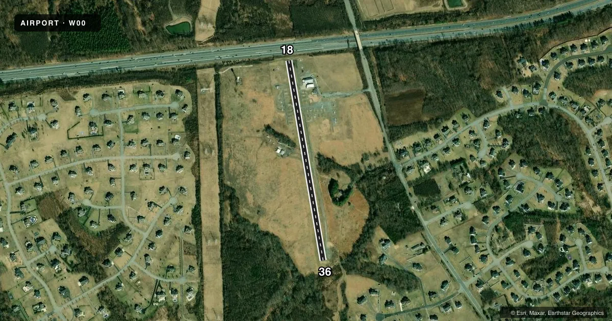
Runways & pattern
Full pagePattern entry · RWY 36
RIGHT TRAFFICRunway end performance
| End | TORA | TODA | ASDA | LDA | VGSI | Approach lights | Obstruction |
|---|---|---|---|---|---|---|---|
| 18 | — | — | — | — | PAPI 2-box right(6°) | — | 67', trees, 848' from thr, 164' R of cntrln, slope 9 |
| 36 | — | — | — | — | PAPI 2-box left(5.5°) | — | 48', trees, 569' from thr, 90' R of cntrln, slope 7 |
Declared distances in feet. TORA = takeoff run available, TODA = takeoff distance, ASDA = accelerate-stop, LDA = landing distance.
Airport sketch
Runways drawn to scale from FAA survey coordinates, rendered over satellite imagery. Not for navigation.
Approaches & charts
Services on the field
Fuel grades, oxygen, maintenance, ramp storage and lighting — as declared to the FAA by the airport operator.
Fuel & services
- Fuel
- 100LL
- Oxygen (bottled)
- Not available
- Oxygen (bulk)
- Not available
- Airframe repair
- Major
- Power plant repair
- Major
- Other services
- CHTR,INSTR,RNTL
Ramp & ground
- Transient storage
- Tie-down
- Customs
- Not available
- Lighting schedule
- SEE RMK
- Beacon schedule
- SS-SR
- Beacon
- White / Green (civil land)(WG)
- Wind indicator
- Lighted
- Segmented circle
- Yes
Fuel & FBOs
Cheapest 100LL and Jet A on the field and nearby. Always confirm with the FBO before taxi.
Airport notes
Surface conditions, obstructions, local procedures, lighting outages and other notes published with each FAA cycle.
General notes
- TPA 1000 FT MSL (832 FT AGL) FOR ACFT LESS THAN 4000 LBS MAX GWT; TPA 1200 FT MSL (1032 FT AGL) FOR ACFT GREATER THAN 4000 LBS.
- -15 FT DROP 80 FT FROM APCH TO RWY 36.
- -7 FT DROP 50 FT FM APCH END RWY 18.
- UNLGTD ANTENNA 135 FT AGL 600 FT NW AER 18.
- FOR CD CTC POTOMAC APCH AT 866-599-3874.
- TWY RUNUP AREA FOR RWY 36 CLSD.
Lighting notes
- ACTVT PAPI RWYS 18 & 36; MIRL RWY 18/36 - CTAF.
Fuel notes
- 100LL100LL AVBL WHEN ATNDD.
Approach & departure obstructions
- 18+7 FT ROAD AT 115 FT OUT, OB.
- 36+18 FT TREES AT 175 FT OUT, 22 FT R.
- 36APCH RATIO 15:1 TO DSPLCD THR AT CNTRLN.
Other notes
- ESTAB PRIOR TO 1959.
- 1UNATNDD MAJOR HOLIDAYS.
VFR map & nearby airports
VFR sectional. Tap any ICAO chip to open that airport.
Key facts · W00
Answer card- ICAO
- W00
- Name
- FREEWAY
- Location
- BOWIE, MARYLAND
- Elevation
- 168.1 ft MSL
- Traffic pattern altitude
- 1,168.1 ft MSL (1,000 AGL)
- Control tower
- Non-towered (use CTAF)
- Total runways
- 1
- Longest runway
- 18/36 · 2,420 ft
- Published ILS approaches
- 0
- Published frequencies
- 4
- Magnetic variation
- 10°
- Current flight rules
- VFR
- Current wind
- 300° at 6 kt
- Favored runway now
- RWY 36
Freeway Airport sits in Bowie, Maryland. Field elevation is 168.1 ft MSL. It has one runway. Runway 18/36 is 2,420 ft of asphalt, so plan your performance with that length in mind. There is no control tower. Clearance delivery goes through Potomac Approach at 866-599-3874. The published pattern altitude is 1,000 ft MSL, which is 832 ft AGL for aircraft under 4,000 lb. Aircraft over 4,000 lb use 1,200 ft MSL, which is 1,032 ft AGL.
No ILS approaches are published here. The field uses CTAF 123.075. UNICOM is also 123.075. Freeway Aviation is on the field and carries 100LL. 100LL fuel is available when attended. The runway lighting is pilot-controlled on CTAF for 18/36. PAPI is also available for both ends. One operational item to watch is the closed taxiway runup area for runway 36. There are also close-in obstructions. Runway 18 has a 7-foot road obstruction near the threshold. Runway 36 has trees near the threshold and a 15-to-1 approach slope to the displaced threshold. The airport is unattended on major holidays. For a first-time arrival, the main things are the short runway, the nearby obstructions. This is an uncontrolled field under Potomac airspace procedures.