METAR & TAF KVKX
KVKX does not publish a METAR.
Showing the nearest reporting station: KDCA (RONALD REAGAN WASHINGTON NTL) · 7.3 NM away. Conditions at KVKX may differ.
METAR · KDCA
Observed 12:52Z
KDCA 271252Z 01004KT 10SM SCT250 26/19 A2986 RMK AO2 SLP110 T02610194
- Wind
- 010° @ 4 kt
- Visibility
- 10 SM
- Temp / Dew
- 26°C / 19°C
- Altimeter
- 29.86 inHg
- Clouds
- SCT
- Density alt
- 1,540 ft
- Ceiling
- Unlimited
- Rules
- VFR
Airport info & contacts
Manager on record, flight service, ARTCC, attendance schedule and pattern altitude — published by the FAA and refreshed every 28 days.
Location
- From city
- 0 NM NE
- VFR sectional
- WASHINGTON
- ARTCC
- ZDC · WASHINGTON
- NOTAM facility
- DCA (NOTAM-D)
Airport manager
- Name
- DAVID WARTOFSKY
- Phone
- 301-248-5720
- Address
- 10300 GLEN WAY, FORT WASHINGTON MD 20744
Flight service · Hours
- FSS DCA
- LEESBURG1-800-WX-BRIEF
- Attendance
- 0700-2200
Frequencies
Tap any row to copy the frequency to your clipboard.
Runways & pattern
Full pagePattern entry · RWY 06
LEFT TRAFFICRunway end performance
| End | TORA | TODA | ASDA | LDA | VGSI | Approach lights | Obstruction |
|---|---|---|---|---|---|---|---|
| 06 | — | — | — | — | PAPI 2-box left(5°) | — | 102', trees, 1074' from thr, 189' R of cntrln, slope 8 |
| 24 | — | — | — | — | PAPI 2-box left(5.5°) | — | 89', trees, 1348' from thr, 94' R of cntrln, slope 12 |
Declared distances in feet. TORA = takeoff run available, TODA = takeoff distance, ASDA = accelerate-stop, LDA = landing distance.
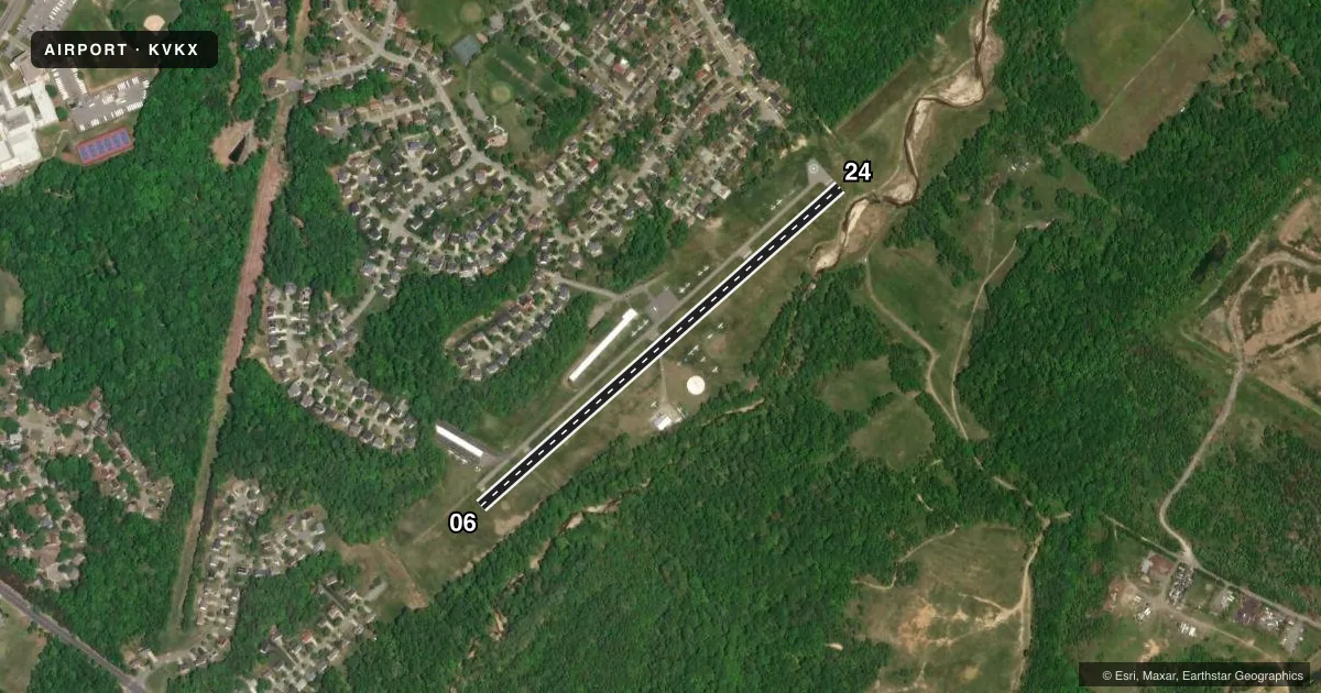
Airport sketch
Runways drawn to scale from FAA survey coordinates, rendered over satellite imagery. Not for navigation.
Approaches & charts
Services on the field
Fuel grades, oxygen, maintenance, ramp storage and lighting — as declared to the FAA by the airport operator.
Fuel & services
- Fuel
- 100LL
- Oxygen (bottled)
- Not available
- Oxygen (bulk)
- Not available
- Airframe repair
- Major
- Power plant repair
- Major
- Other services
- CHTR,INSTR,RNTL
Ramp & ground
- Transient storage
- Tie-down
- Landing fee
- No fee published
- Customs
- Not available
- Lighting schedule
- SEE RMK
- Beacon schedule
- SS-SR
- Beacon
- White / Green (civil land)(WG)
- Wind indicator
- Lighted
- Segmented circle
- Yes
Fuel & FBOs
Cheapest 100LL and Jet A on the field and nearby. Always confirm with the FBO before taxi.
Airport notes
Surface conditions, obstructions, local procedures, lighting outages and other notes published with each FAA cycle.
General notes
- UNLIMITED VEHICLE ACCESS TO ACFT MOVEMENT AREAS.
- VISITORS PLEASE TUNE 122.85 FOR PARKING INSTRUCTIONS & GND SVCS.
- NOISE ABATEMENT PROCEDURES: AVOID TAKEOFF 2200-0700.
- SECURITY: EXPECT 24 HR SURVEILLANCE: CIVIL & MIL, GROUND AND AIR.
- ARPT WITHIN FLT RSTRD ZONE (FRZ).
- RENTALS AVBL AT 301-292-9700.
- FOR CD CTC POTOMAC APCH AT 866-599-3874.
- FRZ PILOTS MUST FILE FRZ SCTY FP THRU 703-771-3476.
- SFRA OR IFR FP DOES NOT GRANT FRZ ASP ACES.
- FOR ACES PILOT MUST BE PRE-APVD THRU TSA MD3 PROGRAM. TO APPLY FOR FRZ ACCESS, SEE ARPT WEBSITE.
Lighting notes
- ROTG BCN LOCATED 1000 FT N OF ARPT.
- MIRL RWY 06/24 OPR SS-SR; TO ACTVT OTR TIMES AND ACTVT PAPI RWY 06 & 24 - CTAF.
Approach & departure obstructions
- 06RWY 06 HAS +60 FT TREES 240 FT R AT THR.
- 24BASIC MKGS PLUS FIELD CARRIER LDG PRACTICE (FCLP) MKGS.
- 06RWY 06 PAPI CNTRLN USE ONLY.
- 06APCH RATIO 20:1 AT CNTRLN TO DSPLCD THR.
- 24APCH SLOPE 15:1 AT CNTRLN TO DSPLCD THR.
Other notes
- ESTAB PRIOR TO 1959.
- AUTOMATED UNICOM; 3 CLICKS ADZY & WX, 4 CLICKS RADIO CHECK.
VFR map & nearby airports
VFR sectional. Tap any ICAO chip to open that airport.
Key facts · KVKX
Answer card- ICAO
- KVKX
- Name
- POTOMAC AIRFIELD
- Location
- FRIENDLY, MARYLAND
- Elevation
- 117.7 ft MSL
- Traffic pattern altitude
- 1,117.7 ft MSL (1,000 AGL)
- Control tower
- Non-towered (use CTAF)
- Total runways
- 1
- Longest runway
- 06/24 · 2,665 ft
- Published ILS approaches
- 0
- Published frequencies
- 6
- Magnetic variation
- 11°
- Current flight rules
- VFR
- Current wind
- 010° at 4 kt
- Favored runway now
- RWY 06
Potomac Airfield is in Friendly, Maryland. The field elevation is 117.7 ft MSL. It has one runway, 06/24, which is 2,665 ft long and paved. There is no control tower. No ILS approaches are published. Pattern altitude is not published in the facts, so verify the current Chart Supplement before you go. The airport sits inside the flight restricted zone, so plan ahead and make sure your clearance and arrival setup are correct before departure.
The on-field FBO is Potomac Airfield. It carries AVGAS 100LL. Call the field directly at (301) 248-5720 for current service details. Published remarks say the airport uses an automated UNICOM. Three clicks gets an advisory and weather. Four clicks gets a radio check. Visitors are told to tune 122.85 for parking instructions and ground services. Medium intensity runway lights on 06/24 operate from sunset to sunrise. Use CTAF to activate them outside those hours. The remarks also note noise abatement. Avoid takeoff between 2200 and 0700. For a first-time arrival, the big items are the FRZ. The runway length and the lighting setup also matter. The field is close in, so brief the arrival carefully and confirm current procedures with the airport operator or the FBO directly by phone.