METAR & TAF KHEF
Current METAR
Observed 08:56Z
KHEF 270856Z AUTO 00000KT 10SM CLR 20/19 A2985 RMK AO2 SLP111 T02000189 56006 $
- Wind
- 000° @ 0 kt
- Visibility
- 10 SM
- Temp / Dew
- 20°C / 19°C
- Altimeter
- 29.85 inHg
- Clouds
- CLR
- Density alt
- 925 ft
- Ceiling
- Unlimited
- Rules
- VFR
Airport info & contacts
Manager on record, flight service, ARTCC, attendance schedule and pattern altitude — published by the FAA and refreshed every 28 days.
Location
- From city
- 28 NM WSW
- VFR sectional
- WASHINGTON
- ARTCC
- ZDC · WASHINGTON
- NOTAM facility
- HEF (NOTAM-D)
Airport manager
- Name
- JUAN RIVERA
- Phone
- 703-361-1882
- Address
- 10600 HARRY J. PARRISH BOULEVARD, MANASSAS VA 20110
Flight service · Hours
- FSS DCA
- LEESBURG1-800-WX-BRIEF
- Attendance
- 0630-2230
Frequencies
Tap any row to copy the frequency to your clipboard.
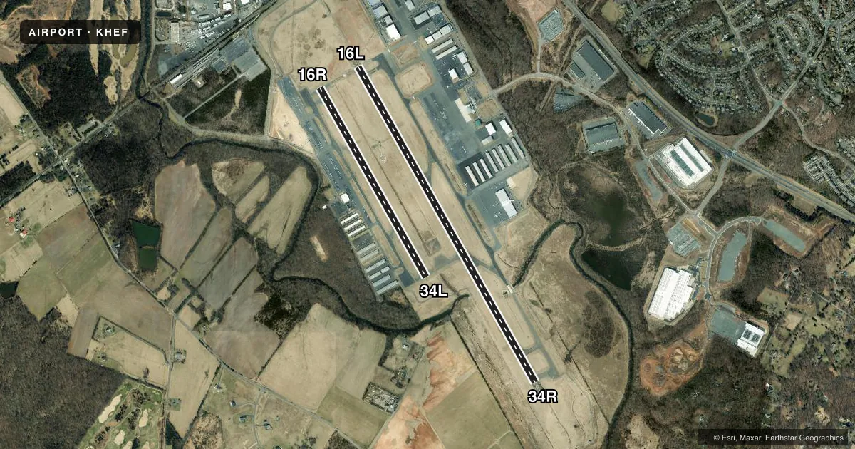
Runways & pattern
Full pagePattern entry · RWY 16L
LEFT TRAFFIC| Runway | Heading (°M) | Length | Surface | Traffic |
|---|---|---|---|---|
| 16L/34R | 141° / 321° | 6,200 ft | ASPH | 34R R |
| 16R/34L | 141° / 321° | 3,715 ft | ASPH | 16R R |
Runway end performance
| End | TORA | TODA | ASDA | LDA | VGSI | Approach lights | Obstruction |
|---|---|---|---|---|---|---|---|
| 16L | — | — | — | — | PAPI 4-box left(3°) | MALSR | 55', trees, 1822' from thr, 358' R of cntrln, slope 29 |
| 34R | — | — | — | — | PAPI 4-box left(3°) | MALSF | 63', trees, 1794' from thr, 329' R of cntrln, slope 25 |
| 16R | — | — | — | — | PAPI 2-box left(3°) | — | 64', tree, 1782' from thr, 150' R of cntrln, slope 24 |
| 34L | — | — | — | — | PAPI 2-box left(3°) | — | 39', trees, 849' from thr, 10' R of cntrln, slope 16 |
Declared distances in feet. TORA = takeoff run available, TODA = takeoff distance, ASDA = accelerate-stop, LDA = landing distance.
Airport sketch
Runways drawn to scale from FAA survey coordinates, rendered over satellite imagery. Not for navigation.
Approaches & charts
ILS · 1
Services on the field
Fuel grades, oxygen, maintenance, ramp storage and lighting — as declared to the FAA by the airport operator.
Fuel & services
- Fuel
- 100LLA
- Oxygen (bottled)
- Low pressure
- Oxygen (bulk)
- HIGH/LOW
- Airframe repair
- Major
- Power plant repair
- Major
- Other services
- AVNCS,CHTR,INSTR,RNTL,SALES
Ramp & ground
- Transient storage
- Tie-down
- Hangar
- Landing fee
- No fee published
- Customs
- Not available
- Lighting schedule
- SEE RMK
- Beacon schedule
- SS-SR
- Beacon
- White / Green (civil land)(WG)
- Wind indicator
- Lighted
- Segmented circle
- Yes
Fuel & FBOs
Cheapest 100LL and Jet A on the field and nearby. Always confirm with the FBO before taxi.
Airport notes
Surface conditions, obstructions, local procedures, lighting outages and other notes published with each FAA cycle.
General notes
- BIRDS & DEER ON & INVOF ARPT.
- HELICOPTER OPS OVER RESIDENTIAL AREAS BLW 1000 FT SHOULD BE AVOIDED; CTC AMGR 703-361-1882 FOR INFO.
- US CUSTOMS AVBL MON-SUN 1000-0400Z. CALL COMMAND CENTER 703-661-2800 FOR APNTMT. 24 HR NOTICE RQRD. ALL WKEND FLIGHTS MUST BE ARNGD BFR 1700 LOCAL ON FRI BFR.
- FOR CD WHEN ATCT IS CLSD CTC POTOMAC APCH AT 866-709-4993.
- TRML APN FOR TSNT AND US CUST PRKG.
- TWY B SAFETY AREA WID 44 FT LATERALLY EAST SIDE FM TWY E TO TWY G.
- ARFF INDEX B SVCS AVBL 0700-1900 DAILY, PPR 48HRS FOR ARFF INDEX C OR STANDBY SVC OUTSIDE OPRG HRS. FEE FOR ADDNL SVC. CALL ARFF AT 703-587-6302.
Lighting notes
- WHEN ATCT CLSD ACTVT MALSR RWY 16L; MALSF RWY 34R; REILS RWY 16R & 34L; HIRL RWY 16L/34R, MIRL RWY 16R/34L - CTAF.
Other notes
- TPA - 1200 MSL SINGLE ENGINE & LGT TWIN ACFT; 1500 MSL MED TWIN & TURBOPROP ACFT; 1000 MSL HELICOPTER.
VFR map & nearby airports
VFR sectional. Tap any ICAO chip to open that airport.
Key facts · KHEF
Answer card- ICAO
- KHEF
- Name
- WASHINGTON MANASSAS/HARRY P DAVIS FLD
- Location
- WASHINGTON, DIST. OF COLUMBIA
- Elevation
- 192.2 ft MSL
- Traffic pattern altitude
- 1,192.2 ft MSL (1,000 AGL)
- Control tower
- Towered · 0630-2230
- Total runways
- 2
- Longest runway
- 16L/34R · 6,200 ft
- Published ILS approaches
- 1
- Published frequencies
- 9
- Magnetic variation
- 10°
- Current flight rules
- VFR
- Current wind
- 000° at 0 kt
- Favored runway now
- –
KHEF is Manassas Rgnl/Harry P Davis Fld in Manassas, in the Washington, District of Columbia area. Field elevation is 192.2 ft MSL. The airport has 2 asphalt runways. The longest is 16L/34R at 6,200 ft. The other runway is 16R/34L at 3,715 ft. The tower is open daily from 0630 to 2230.
There is 1 ILS approach. It is for runway 16L. Pattern altitude is published as 1,200 ft MSL for single engine and light twin aircraft. Medium twin and turboprop aircraft use 1,500 ft MSL. Helicopters use 1,000 ft MSL. The field sits in a busy metro area. Helicopter operations over residential areas below 1,000 ft should be avoided. Birds and deer are reported on and near the airport. Keep a sharp scan on taxi, takeoff and final.
Two on-field FBOs are listed. Chantilly Air Jet Center carries 100LL and Jet A Prist. APP Jet Center carries 100LL and Jet A Prist. When the tower is closed, use CTAF for lighting activation. The published remarks also note customs service by appointment with advance notice. For clearance delivery when the tower is closed, contact Potomac Approach. If you need current procedures, check the current FAA Chart Supplement or call the airport operator or FBO directly.