METAR & TAF KIAD
Current METAR
Observed 04:52Z
KIAD 280452Z 19008KT 10SM CLR 24/20 A2978 RMK AO2 SLP082 T02440200 403060200
- Wind
- 190° @ 8 kt
- Visibility
- 10 SM
- Temp / Dew
- 24°C / 20°C
- Altimeter
- 29.78 inHg
- Clouds
- CLR
- Density alt
- 1,641 ft
- Ceiling
- Unlimited
- Rules
- VFR
Airport info & contacts
Manager on record, flight service, ARTCC, attendance schedule and pattern altitude — published by the FAA and refreshed every 28 days.
Location
- From city
- 20 NM W
- VFR sectional
- WASHINGTON
- ARTCC
- ZDC · WASHINGTON
- NOTAM facility
- IAD (NOTAM-D)
Airport manager
- Name
- RICHARD GOLINOWSKI
- Phone
- 703-572-2730
- Address
- 1 SAARINEN CIRCLE, SAARINEN CENTER MA-210, DULLES VA 20166
Flight service · Hours
- FSS DCA
- LEESBURG1-800-WX-BRIEF
- Attendance
- ALL
Frequencies
Tap any row to copy the frequency to your clipboard.
Runways & pattern
Full pagePattern entry · RWY 19L
LEFT TRAFFIC| Runway | Heading (°M) | Length | Surface | Traffic |
|---|---|---|---|---|
| 01R/19LFavored | 351° / 171° | 11,500 ft | CONC | Standard L |
| 01C/19C | 351° / 171° | 11,500 ft | CONC | Standard L |
| 12/30 | 101° / 281° | 10,501 ft | CONC | Standard L |
| 01L/19R | 351° / 171° | 9,400 ft | CONC | Standard L |
Runway end performance
| End | TORA | TODA | ASDA | LDA | VGSI | Approach lights | Obstruction |
|---|---|---|---|---|---|---|---|
| 01R | 11,500' | 11,500' | 11,500' | 11,500' | PAPI 4-box right(3°) | ALSF2 | — |
| 19L | 11,500' | 11,500' | 11,500' | 11,500' | PAPI 4-box left(3°) | ALSF2 | 38', pole, 1900' from thr, 720' R of cntrln, slope 44 |
| 01C | 11,500' | 11,500' | 11,500' | 11,500' | PAPI 4-box left(3°) | MALSR | — |
| 19C | 11,500' | 11,500' | 11,500' | 11,089' | PAPI 4-box right(3°) | ALSF2 | — |
| 12 | 10,501' | 10,501' | 10,501' | 10,501' | PAPI 4-box right(3°) | MALSR | — |
| 30 | 10,501' | 10,501' | 10,501' | 10,501' | PAPI 4-box left(3°) | — | — |
| 01L | 9,400' | 9,400' | 9,400' | 9,400' | PAPI 4-box left(3°) | ALSF2 | — |
| 19R | 9,400' | 9,400' | 9,400' | 9,400' | PAPI 4-box left(3°) | ALSF2 | — |
Declared distances in feet. TORA = takeoff run available, TODA = takeoff distance, ASDA = accelerate-stop, LDA = landing distance.
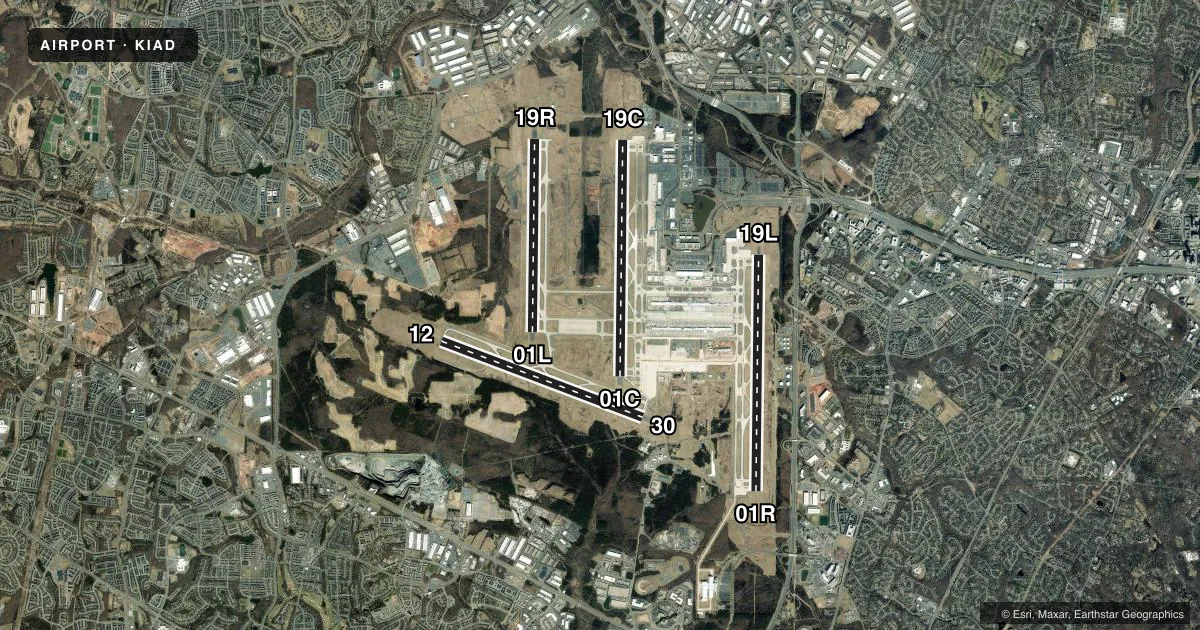
Airport sketch
Runways drawn to scale from FAA survey coordinates, rendered over satellite imagery. Not for navigation.
Approaches & charts
ILS · 7
Services on the field
Fuel grades, oxygen, maintenance, ramp storage and lighting — as declared to the FAA by the airport operator.
Fuel & services
- Fuel
- 100LLA
- Oxygen (bottled)
- High pressure
- Oxygen (bulk)
- High pressure
- Airframe repair
- Major
- Power plant repair
- Major
- Other services
- AFRT,AVNCS,CARGO,SALES
Ramp & ground
- Transient storage
- Tie-down
- Hangar
- Landing fee
- Yes
- Customs
- Not available
- Beacon schedule
- SS-SR
- Beacon
- White / Green (civil land)(WG)
- Wind indicator
- Lighted
- Segmented circle
- No
Fuel & FBOs
Cheapest 100LL and Jet A on the field and nearby. Always confirm with the FBO before taxi.
Airport notes
Surface conditions, obstructions, local procedures, lighting outages and other notes published with each FAA cycle.
General notes
- ITNRNT ACFT CTC FBO ON 122.95 OR 129.77 FOR SVCS.
- ACR PUSH BACKS & PWR FM ALL APRON PSNS REQUIRE CLNC FM MWAA RAMP TWR.
- LARGE FLOCKS OF BIRDS ON & INVOF ARPT/DEER INVOF ARPT.
- DURING PERIODS OF ACFT SATURATION LONG TERM PARKING MAY NOT BE AVAILABLE. SERVICES FOR FUEL AND GO ONLY WILL BE AVAILABLE.
- FLIGHT TRAINING BETWEEN 2200-0700 IS PROHIBITED.
- TAXILANE 'C' ACTIVE; PUSHBACK CLNCS ON NORTH SIDE OF MIDFIELD TERMINAL ARE ONTO TAXILANE 'D' ONLY UNLESS OTHERWISE AUTH.
- ALL AIRCRAFT WITH WINGSPAN EXCEEDING 118 FT ARE RESTRICTED FROM USING TAXILANE A BTN A1 & A5.
- RUNUP BLX FOR RWY 30 DSGND AS NON-MOVEMENT AREA.
- ALL 180 DEG TURNS OUT OF APRON POSITIONS SHALL BE MADE USING MINIMUM POWER.
- LDG FEE. FLIGHT NOTIFICATION SERVICE (ADCUS) AVBL. NOTE: SEE SPECIAL NOTICES --CONTINUOUS POWER FACILITIES.
- TXL E1 CLSD TO ACFT WINGSPAN MORE THAN 118 FT.
- B747-8 RESTRICTED TO MAXIMUM TAXI SPEED 17 KTS (20 MPH) ON TWY J.
- ENGINE RUN-UPS BTW 2200L & 0700L REQUIRE PRIOR APPROVAL FM ARPT OPS.
- RWY 30 DEPARTURES USE UPPER ANTENNA FOR ATC COMMUNICATIONS.
- RWY STATUS LGTS ARE IN OPN.
- PILOTS CONDUCTING EFVS OPS; BE AWARE LED ALS IN USE RWY 01C.
- COCKPIT OVER CNTRLN TAXI PROHIBITED AT TWY Y INT WITH TWY Y11. JUDGMENTAL OVERSTEER RQRED.
Runway surface & condition
- 01C/19CPCR VALUE: 1089/R/B/W/T
- 01L/19RPCR VALUE: 1045/R/B/W/T
- 01R/19LPCR VALUE: 1005/R/B/W/U
- 12/30PCR VALUE: 1108/R/B/W/T
Other notes
- LOCATED IN BOTH FAIRFAX COUNTY VA AND LOUDOUN COUNTY VA.
VFR map & nearby airports
VFR sectional. Tap any ICAO chip to open that airport.
Key facts · KIAD
Answer card- ICAO
- KIAD
- Name
- WASHINGTON DULLES INTL
- Location
- WASHINGTON, DIST. OF COLUMBIA
- Elevation
- 312.3 ft MSL
- Traffic pattern altitude
- 1,312.3 ft MSL (1,000 AGL)
- Control tower
- Towered · 24
- Total runways
- 4
- Longest runway
- 01R/19L · 11,500 ft
- Published ILS approaches
- 7
- Published frequencies
- 29
- Magnetic variation
- 10°
- Current flight rules
- VFR
- Current wind
- 190° at 8 kt
- Favored runway now
- RWY 19L
Washington Dulles Intl sits in the Washington, District of Columbia area. The field elevation is 312.3 ft MSL. It has four runways. The longest runways are 11,500 ft. The tower is open 24 hours. Seven ILS approaches are published. Pattern altitude is not published, so light piston pilots should plan on the standard 1,000 ft AGL unless current instructions say otherwise.
This is a busy Class B airport environment, so expect heavy airline traffic and close coordination on the radios. Atlantic Aviation and Signature Aviation are on the field. Both carry 100LL and Jet A. For itinerant service, the airport remarks say to contact the FBO on 122.95 or 129.77. The airport also notes that pushbacks and power from apron positions need MWAA ramp tower clearance. Taxi and ground movement can be tight. Taxilane C is active. North side pushbacks from the midfield terminal are normally onto taxilane D unless told otherwise.
The published remarks also flag birds and deer in the area. Flight training is prohibited between 2200 and 0700. Runway 01C uses LED approach lighting, which matters for EFVS crews. If you are planning a stop here, check the current FAA Chart Supplement for any current restrictions before departure.