METAR & TAF W50
W50 does not publish a METAR.
Showing the nearest reporting station: KGAI (MONTGOMERY COUNTY AIRPARK) · 4.6 NM away. Conditions at W50 may differ.
METAR · KGAI
Observed 11:56Z
KGAI 271156Z AUTO 30003KT 10SM CLR 22/21 A2989 RMK AO2 SLP130 T02170211 10239 20200 53011
- Wind
- 300° @ 3 kt
- Visibility
- 10 SM
- Temp / Dew
- 22°C / 21°C
- Altimeter
- 29.89 inHg
- Clouds
- CLR
- Density alt
- 1,632 ft
- Ceiling
- Unlimited
- Rules
- VFR
Airport info & contacts
Manager on record, flight service, ARTCC, attendance schedule and pattern altitude — published by the FAA and refreshed every 28 days.
Location
- From city
- 3 NM N
- VFR sectional
- WASHINGTON
- Pattern altitude
- 800 ft AGL · 1,409 ft MSL
- ARTCC
- ZDC · WASHINGTON
- NOTAM facility
- DCA (NOTAM-D)
Airport manager
- Name
- ALICIA HARVEY STANLEY
- Phone
- 301-253-2897
- Address
- 7200 HAWKINS CREAMERY RD, LAYTONSVILLE MD 20882
Flight service · Hours
- FSS DCA
- LEESBURG1-800-WX-BRIEF
- Attendance
- MON-FRI · DAWN-DUSK
Frequencies
Tap any row to copy the frequency to your clipboard.
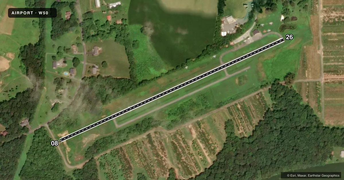
Runways & pattern
Full pagePattern entry · RWY 26
LEFT TRAFFICRunway end performance
| End | TORA | TODA | ASDA | LDA | VGSI | Approach lights | Obstruction |
|---|---|---|---|---|---|---|---|
| 08 | — | — | — | — | — | — | 57', trees, 714' from thr, 87' R of cntrln, slope 9 |
| 26 | — | — | — | — | — | — | 44', trees, 838' from thr, 177' R of cntrln, slope 14 |
Declared distances in feet. TORA = takeoff run available, TODA = takeoff distance, ASDA = accelerate-stop, LDA = landing distance.
Airport sketch
Runways drawn to scale from FAA survey coordinates, rendered over satellite imagery. Not for navigation.
Approaches & charts
Services on the field
Fuel grades, oxygen, maintenance, ramp storage and lighting — as declared to the FAA by the airport operator.
Fuel & services
- Fuel
- 100LL
- Oxygen (bottled)
- Not available
- Oxygen (bulk)
- Not available
- Airframe repair
- Minor
- Power plant repair
- Minor
- Other services
- INSTR,RNTL
Ramp & ground
- Transient storage
- Tie-down
- Landing fee
- No fee published
- Wind indicator
- Yes
- Segmented circle
- No
Fuel & FBOs
Cheapest 100LL and Jet A on the field and nearby. Always confirm with the FBO before taxi.
Airport notes
Surface conditions, obstructions, local procedures, lighting outages and other notes published with each FAA cycle.
General notes
- ARPT CLSD DUSK-DAWN.
- BIRDS & WILDLIFE ON & INVOF ARPT.
- TOUCH & GO OPS NA.
- FOR CD CTC POTOMAC APCH AT 866-429-5882.
Approach & departure obstructions
- 26POND 80 FT R OF THR.
Other notes
- ESTAB PRIOR TO 1959.
- UNICOM UNMON.
VFR map & nearby airports
VFR sectional. Tap any ICAO chip to open that airport.
Key facts · W50
Answer card- ICAO
- W50
- Name
- DAVIS
- Location
- LAYTONSVILLE, MARYLAND
- Elevation
- 609 ft MSL
- Traffic pattern altitude
- 1,409 ft MSL (800 AGL)
- Control tower
- Non-towered (use CTAF)
- Total runways
- 1
- Longest runway
- 08/26 · 2,600 ft
- Published ILS approaches
- 0
- Published frequencies
- 2
- Magnetic variation
- 9°
- Current flight rules
- VFR
- Current wind
- 300° at 3 kt
- Favored runway now
- RWY 26
Davis Airport (W50) sits in Laytonsville, Maryland. The field elevation is 609 ft MSL. It has one runway, 08/26, which is 2,600 ft long and paved asphalt. The airport is non-towered. CTAF and UNICOM are both 122.8, though the UNICOM is unmonitored.
Pattern altitude is 800 ft AGL, which is 1,409 ft MSL. No ILS approaches are published here, so plan with that in mind if the weather is marginal. The airport is closed from dusk to dawn. Touch-and-go operations are not authorized. For clearance delivery, contact Potomac Approach at 866-429-5882.
Davis Airport is a small field with one on-field FBO, Davis Airport. Fuel grades are not reported in the facts, so call ahead at (301) 253-2897 if you need current fuel details. Published remarks also note birds and wildlife on and near the airport. There is a pond about 80 feet right of the threshold for runway 26, so give that end extra attention on arrival and departure. The field was established prior to 1959. For current operational details, check the current FAA Chart Supplement or call the airport operator directly before you go.