METAR & TAF 2W2
2W2 does not publish a METAR.
Showing the nearest reporting station: KDMW (CARROLL COUNTY RGNL/JACK B POAGE FLD) · 8.5 NM away. Conditions at 2W2 may differ.
METAR · KDMW
Observed 07:35Z
KDMW 270735Z AUTO VRB01KT 10SM OVC055 20/19 A2985 RMK AO2
- Wind
- VAR @ 1 kt
- Visibility
- 10 SM
- Temp / Dew
- 20°C / 19°C
- Altimeter
- 29.85 inHg
- Clouds
- OVC
- Density alt
- 1,677 ft
- Ceiling
- 5,500 ft AGL
- Rules
- VFR
Airport info & contacts
Manager on record, flight service, ARTCC, attendance schedule and pattern altitude — published by the FAA and refreshed every 28 days.
Location
- From city
- 7 NM S
- VFR sectional
- WASHINGTON
- ARTCC
- ZDC · WASHINGTON
- NOTAM facility
- DCA (NOTAM-D)
Airport manager
- Name
- WALTER S. TEGELER, III
- Phone
- 410-984-2434
- Address
- 519 OAK TREE ROAD, WESTMINSTER MD 21157
Flight service · Hours
- FSS DCA
- LEESBURG1-800-WX-BRIEF
- Attendance
- 0900-1700
Frequencies
Tap any row to copy the frequency to your clipboard.
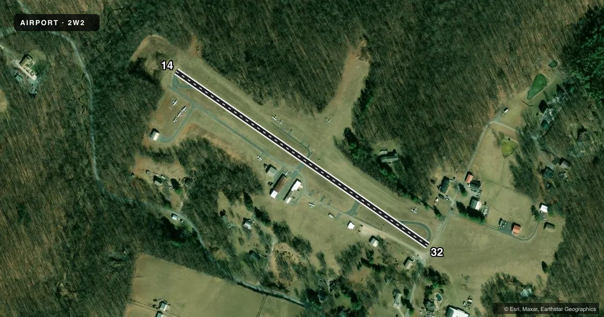
Runways & pattern
Full pagePattern entry · RWY 32
LEFT TRAFFICRunway end performance
| End | TORA | TODA | ASDA | LDA | VGSI | Approach lights | Obstruction |
|---|---|---|---|---|---|---|---|
| 14 | — | — | — | — | PNIL(4°) | — | 40', trees, 814' from thr, 128' R of cntrln, slope 15 |
| 32 | — | — | — | — | PNIL(7°) | — | 21', trees, 458' from thr, 40' R of cntrln, slope 12 |
Declared distances in feet. TORA = takeoff run available, TODA = takeoff distance, ASDA = accelerate-stop, LDA = landing distance.
Airport sketch
Runways drawn to scale from FAA survey coordinates, rendered over satellite imagery. Not for navigation.
Approaches & charts
Services on the field
Fuel grades, oxygen, maintenance, ramp storage and lighting — as declared to the FAA by the airport operator.
Fuel & services
- Fuel
- 100LL
- Oxygen (bottled)
- Not available
- Oxygen (bulk)
- Not available
- Airframe repair
- Not available
- Power plant repair
- Not available
- Other services
- INSTR,RNTL
Ramp & ground
- Transient storage
- Tie-down
- Landing fee
- No fee published
- Lighting schedule
- SEE RMK
- Beacon schedule
- SEE RMK
- Beacon
- White / Green (civil land)(WG)
- Wind indicator
- Lighted
- Segmented circle
- No
Fuel & FBOs
Cheapest 100LL and Jet A on the field and nearby. Always confirm with the FBO before taxi.
Airport notes
Surface conditions, obstructions, local procedures, lighting outages and other notes published with each FAA cycle.
General notes
- 60 FT DROP OFF 125 FT FM AER 14.
- ULTRALIGHT ACT ON & INVOF ARPT.
- UNL VEHICLE ACES TO ACFT MOVEMENT AREAS.
- FOR CD CTC POTOMAC APCH AT 866-429-5882.
Lighting notes
- ACTVT ROTG BCN - CTAF.
- ACTVT LIRL RWY 14/32 - CTAF.
Runway surface & condition
- 14/32NSTD - LGTS 20 FT FM RWY EDGE.
Approach & departure obstructions
- 1440 FT TREES, 124 FT LEFT OF THLD.
- 3210 FT PVT ROAD AT THLD; 60 FT TREES, 140 FT RIGHT.
- 32APCH RATIO 20:1 TO DSPLCD THR.
Other notes
- 1ARPT UNATNDD THANKSGIVING, CHRISTMAS & NEW YEARS DAY.
VFR map & nearby airports
VFR sectional. Tap any ICAO chip to open that airport.
Key facts · 2W2
Answer card- ICAO
- 2W2
- Name
- CLEARVIEW AIRPARK
- Location
- WESTMINSTER, MARYLAND
- Elevation
- 798.6 ft MSL
- Traffic pattern altitude
- 1,798.6 ft MSL (1,000 AGL)
- Control tower
- Non-towered (use CTAF)
- Total runways
- 1
- Longest runway
- 14/32 · 1,840 ft
- Published ILS approaches
- 0
- Published frequencies
- 4
- Magnetic variation
- 11°
- Current flight rules
- VFR
- Current wind
- 000° at 1 kt
- Favored runway now
- RWY 32
Clearview Airpark is in Westminster, Maryland. The field elevation is 798.6 ft MSL. It has one runway, 14/32, which is 1,840 ft long and asphalt. There is no control tower. No ILS approaches are published here. Pattern altitude is not published, so verify the current traffic pattern altitude before arrival.
The on-field FBO is Clearview Airport. It carries AVGAS 100LL. Call the FBO directly at (410) 795-9840 for current service details. Potomac Approach handles clearance delivery and approach or departure support on 125.525 and 291.625 MHz. CTAF and UNICOM are both 122.8.
A few remarks matter here. The rotating beacon and the low-intensity runway lights are activated by CTAF. The runway lights are nonstandard and sit 20 feet from the runway edge. There are trees near both runway ends. Runway 14 has 40-foot trees 124 feet left of the threshold. Runway 32 has a 10-foot private road at the threshold plus 60-foot trees 140 feet to the right. There is also a 60-foot drop-off 125 feet from aerodrome 14. Ultralight activity occurs on and near the airport. Unleashed vehicles can access aircraft movement areas, so keep a sharp lookout on the ground.