METAR & TAF KDMW
Current METAR
Observed 14:55Z
KDMW 271455Z AUTO 32006KT 10SM CLR 26/17 A2989 RMK AO2
- Wind
- 320° @ 6 kt
- Visibility
- 10 SM
- Temp / Dew
- 26°C / 17°C
- Altimeter
- 29.89 inHg
- Clouds
- CLR
- Density alt
- 2,336 ft
- Ceiling
- Unlimited
- Rules
- VFR
Airport info & contacts
Manager on record, flight service, ARTCC, attendance schedule and pattern altitude — published by the FAA and refreshed every 28 days.
Location
- From city
- 3 NM N
- VFR sectional
- WASHINGTON
- ARTCC
- ZDC · WASHINGTON
- NOTAM facility
- DMW (NOTAM-D)
Airport manager
- Name
- M. DEAN LEISTER
- Phone
- 410-876-9885
- Address
- 200 AIRPORT DRIVE, BOX 8, WESTMINSTER MD 21157
Flight service · Hours
- FSS DCA
- LEESBURG1-800-WX-BRIEF
- Attendance
- 0700-2000
Frequencies
Tap any row to copy the frequency to your clipboard.
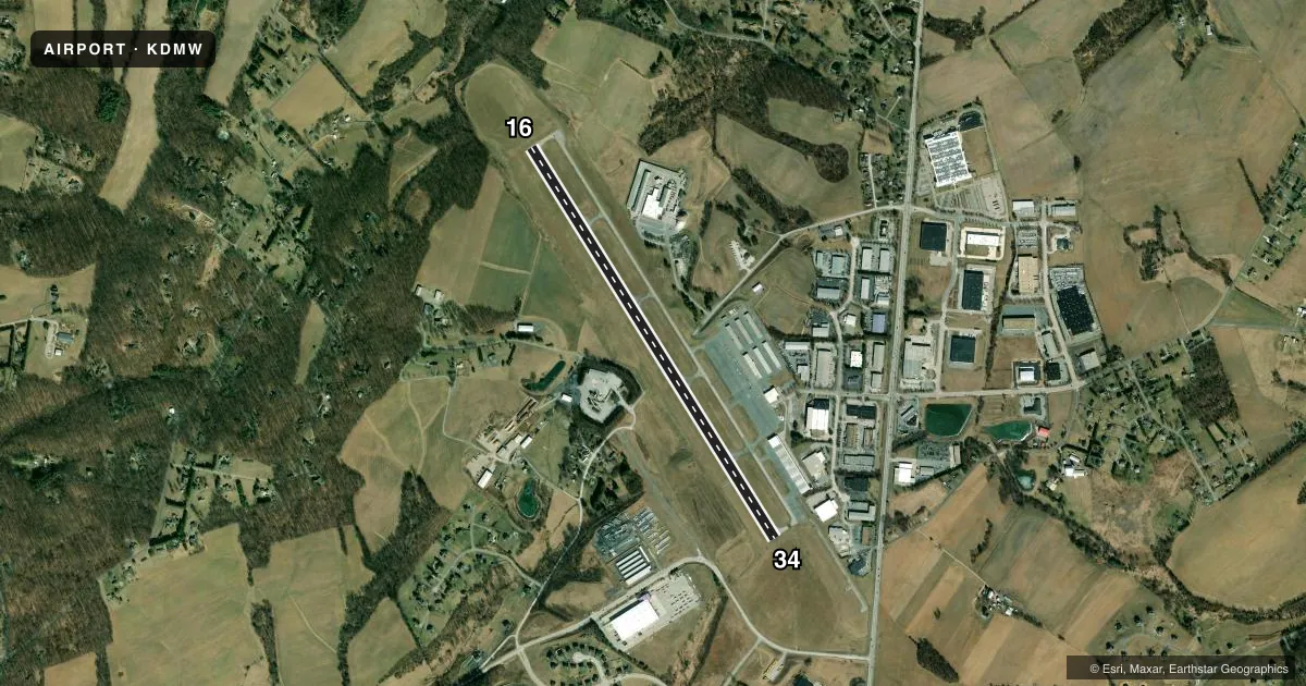
Runways & pattern
Full pagePattern entry · RWY 34
RIGHT TRAFFICRunway end performance
| End | TORA | TODA | ASDA | LDA | VGSI | Approach lights | Obstruction |
|---|---|---|---|---|---|---|---|
| 16 | — | — | — | — | PAPI 4-box left(3°) | — | 72', trees, 2415' from thr, 602' R of cntrln, slope 30 |
| 34 | — | — | — | — | PAPI 4-box left(3°) | — | — |
Declared distances in feet. TORA = takeoff run available, TODA = takeoff distance, ASDA = accelerate-stop, LDA = landing distance.
Airport sketch
Runways drawn to scale from FAA survey coordinates, rendered over satellite imagery. Not for navigation.
Approaches & charts
Services on the field
Fuel grades, oxygen, maintenance, ramp storage and lighting — as declared to the FAA by the airport operator.
Fuel & services
- Fuel
- 100LLA
- Oxygen (bottled)
- HIGH/LOW
- Airframe repair
- Major
- Power plant repair
- Major
- Other services
- CHTR,INSTR,RNTL,SALES
Ramp & ground
- Transient storage
- Tie-down
- Hangar
- Landing fee
- No fee published
- Customs
- Not available
- Lighting schedule
- SEE RMK
- Beacon schedule
- SS-SR
- Beacon
- White / Green (civil land)(WG)
- Wind indicator
- Lighted
- Segmented circle
- Yes
Fuel & FBOs
Cheapest 100LL and Jet A on the field and nearby. Always confirm with the FBO before taxi.
Airport notes
Surface conditions, obstructions, local procedures, lighting outages and other notes published with each FAA cycle.
General notes
- ARPT UNATNDD CHRISTMAS.
- WILDLIFE ON & INVOF ARPT.
- GCO AVBL ON FREQ 121.725. IF UNA, FOR CD CTC POTOMAC APCH AT 866-429-5882.
Lighting notes
- ACTVT REIL RWYS 16 & 34; MIRL RWY 16/34; TWY LGTS - CTAF.
Fuel notes
- 100LLSELF SERVE 100LL AVAILABLE WITH CREDIT CARD.
Runway surface & condition
- 16/34DISTANCE MARKERS EVERY 1000 FT WEST SIDE OF RWY.
Approach & departure obstructions
- 16PAPI RWY 16 UNUSBL BYD 5 DEGS R OF CNTRLN.
Other notes
- THIS AIRPORT HAS BEEN SURVEYED BY THE NATIONAL GEODETIC SURVEY.
- TPA FIXED WING 810 FT, TURBO PROP & JET 1310 FT.
VFR map & nearby airports
VFR sectional. Tap any ICAO chip to open that airport.
Key facts · KDMW
Answer card- ICAO
- KDMW
- Name
- CARROLL COUNTY RGNL/JACK B POAGE FLD
- Location
- WESTMINSTER, MARYLAND
- Elevation
- 789.2 ft MSL
- Traffic pattern altitude
- 1,789.2 ft MSL (1,000 AGL)
- Control tower
- Non-towered (use CTAF)
- Total runways
- 1
- Longest runway
- 16/34 · 5,100 ft
- Published ILS approaches
- 0
- Published frequencies
- 4
- Magnetic variation
- 11°
- Current flight rules
- VFR
- Current wind
- 320° at 6 kt
- Favored runway now
- RWY 34
Carroll County Rgnl/Jack B Poage Fld sits in Westminster, Maryland. Field elevation is 789.2 ft MSL. The airport has one runway, 16/34, at 5,100 ft. There is no control tower. Potomac Approach handles the area on 125.525 and 291.625 MHz. No ILS approaches are published here.
The published pattern altitude is 810 ft AGL for fixed-wing aircraft. That puts the fixed-wing pattern at 1,599.2 ft MSL. Turboprop and jet traffic uses 1,310 ft AGL. The field is on the higher side for the region. Plan for a little more density altitude than you would at a low coastal airport, especially on warm days.
PILATUS, formerly Skytech, is on the field. It carries 100LL and Jet A Prist. Self-serve 100LL is available with credit card. Runway end identifier lights are installed on 16 and 34. Medium intensity runway lights are on the runway. Taxiway lights are controlled by CTAF. The airport also has wildlife in and around the field. One published note says the PAPI for runway 16 is unusable beyond 5 degrees right of centerline. First-time arrivals should brief that before final.