METAR & TAF N71
N71 does not publish a METAR.
Showing the nearest reporting station: KMDT (HARRISBURG INTL) · 10.6 NM away. Conditions at N71 may differ.
METAR · KMDT
Observed 15:56Z
KMDT 271556Z 29009KT 10SM FEW040 FEW100 BKN250 28/17 A2985 RMK AO2 SLP105 T02780172
- Wind
- 290° @ 9 kt
- Visibility
- 10 SM
- Temp / Dew
- 28°C / 17°C
- Altimeter
- 29.85 inHg
- Clouds
- BKN
- Density alt
- 2,215 ft
- Ceiling
- 25,000 ft AGL
- Rules
- VFR
Airport info & contacts
Manager on record, flight service, ARTCC, attendance schedule and pattern altitude — published by the FAA and refreshed every 28 days.
Location
- From city
- 3 NM SW
- VFR sectional
- NEW YORK
- ARTCC
- ZNY · NEW YORK
- NOTAM facility
- IPT (NOTAM-D)
Airport manager
- Name
- BENJAMIN TRAVIS
- Phone
- 717-928-4360
- Address
- 186 AIRPORT RD, MARIETTA PA 17547
Flight service · Hours
- FSS IPT
- WILLIAMSPORT1-800-WX-BRIEF
- Attendance
- MON-FRI · 0800-1630
- SAT · UNATTND
- SUN · UNATTND
Frequencies
Tap any row to copy the frequency to your clipboard.
Runways & pattern
Full pagePattern entry · RWY 28
LEFT TRAFFICRunway end performance
| End | TORA | TODA | ASDA | LDA | VGSI | Approach lights | Obstruction |
|---|---|---|---|---|---|---|---|
| 10 | — | — | — | — | — | — | 35', pole, 606' from thr, 244' R of cntrln, slope 11 |
Declared distances in feet. TORA = takeoff run available, TODA = takeoff distance, ASDA = accelerate-stop, LDA = landing distance.
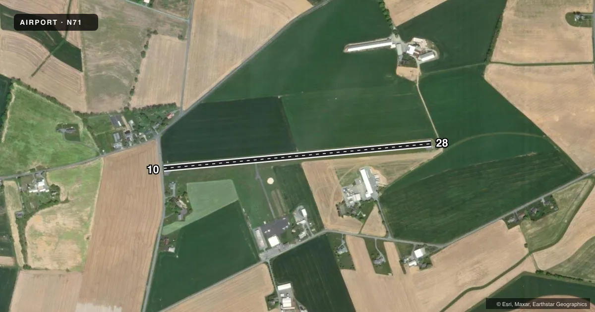
Airport sketch
Runways drawn to scale from FAA survey coordinates, rendered over satellite imagery. Not for navigation.
Approaches & charts
Services on the field
Fuel grades, oxygen, maintenance, ramp storage and lighting — as declared to the FAA by the airport operator.
Fuel & services
- Fuel
- 100LL
- Oxygen (bottled)
- Not available
- Oxygen (bulk)
- Not available
- Airframe repair
- Major
- Power plant repair
- Not available
- Other services
- AVNCS,PAJA
Ramp & ground
- Transient storage
- Tie-down
- Landing fee
- No fee published
- Customs
- Not available
- Lighting schedule
- SEE RMK
- Beacon schedule
- SEE RMK
- Beacon
- White / Green (civil land)(WG)
- Wind indicator
- Yes
- Segmented circle
- No
Fuel & FBOs
Cheapest 100LL and Jet A on the field and nearby. Always confirm with the FBO before taxi.
Airport notes
Surface conditions, obstructions, local procedures, lighting outages and other notes published with each FAA cycle.
General notes
- FOR CD CTC HARRISBURG APCH AT 800-932-0712.
Lighting notes
- ACTVT ROTG BCN - CTAF
- ACTVT MIRL RWY 10/28 - CTAF.
Approach & departure obstructions
- 10RWY 10; 15 FT ROAD 16 FT FM RWY END.
- 10RWY 10 DTHR BAR 300 FT FM RWY END, DTHR LGTS 300 FT FM RWY END.
- 10RWY 10 APCH SLOPE RATIO 20:1 TO DTHR LGTS 300 FT FM RWY END.
- 10RWY 10 HAS 30 FT HOUSE 190 FT FM DTHR, 206 FT RIGHT; APCH RATIO 6:1 TO DTHR.
Other notes
- THIS AIRPORT HAS BEEN SURVEYED BY THE NATIONAL GEODETIC SURVEY.
VFR map & nearby airports
VFR sectional. Tap any ICAO chip to open that airport.
Key facts · N71
Answer card- ICAO
- N71
- Name
- DONEGAL SPRINGS AIRPARK
- Location
- MOUNT JOY/MARIETTA, PENNSYLVANIA
- Elevation
- 458 ft MSL
- Traffic pattern altitude
- 1,458 ft MSL (1,000 AGL)
- Control tower
- Non-towered (use CTAF)
- Total runways
- 1
- Longest runway
- 10/28 · 3,250 ft
- Published ILS approaches
- 0
- Published frequencies
- 5
- Magnetic variation
- 9°
- Current flight rules
- VFR
- Current wind
- 290° at 9 kt
- Favored runway now
- RWY 28
Donegal Springs Airpark sits in Mount Joy/Marietta, Pennsylvania. The field elevation is 458 ft MSL. It has one runway. Runway 10/28 is 3,250 ft long and asphalt. There is no control tower. No ILS approaches are published here.
Pattern altitude is not published. Use the standard 1,000 ft AGL for light piston traffic unless the current Chart Supplement says otherwise. The field uses CTAF and UNICOM 122.8. Harrisburg Approach handles approach and departure services on the published frequencies. For clearance delivery, the Chart Supplement lists Harrisburg Approach by phone.
Donegal Springs Airpark has one on-field FBO. Donegal Springs Airpark carries 100LL. The airport remarks also call out runway 10 obstacles and displaced threshold markings. Runway 10 has a road close to the end of the runway. It also has a house near the approach path. Plan the departure and arrival with those notes in mind. The runway lights and rotating beacon are activated on CTAF. This is a good field to brief carefully before arrival, especially if you are flying a higher-performance airplane or operating at night.