METAR & TAF 0P8
0P8 does not publish a METAR.
Showing the nearest reporting station: KTHV (YORK) · 7.0 NM away. Conditions at 0P8 may differ.
METAR · KTHV
Observed 05:53Z
KTHV 270553Z AUTO 00000KT 10SM BKN110 18/17 A2986 RMK AO2 SLP109 T01780172 10250 20178 56004
- Wind
- 000° @ 0 kt
- Visibility
- 10 SM
- Temp / Dew
- 18°C / 17°C
- Altimeter
- 29.86 inHg
- Clouds
- BKN
- Density alt
- 1,025 ft
- Ceiling
- 11,000 ft AGL
- Rules
- VFR
Airport info & contacts
Manager on record, flight service, ARTCC, attendance schedule and pattern altitude — published by the FAA and refreshed every 28 days.
Location
- From city
- 3 NM E
- VFR sectional
- NEW YORK
- ARTCC
- ZNY · NEW YORK
- NOTAM facility
- IPT (NOTAM-D)
Airport manager
- Name
- HARRIET T. GRAY
- Phone
- 717-577-8827
- Address
- 3883 BULL ROAD, DOVER PA 17315
Flight service · Hours
- FSS IPT
- WILLIAMSPORT1-800-WX-BRIEF
- Attendance
- Unattended
Frequencies
Tap any row to copy the frequency to your clipboard.
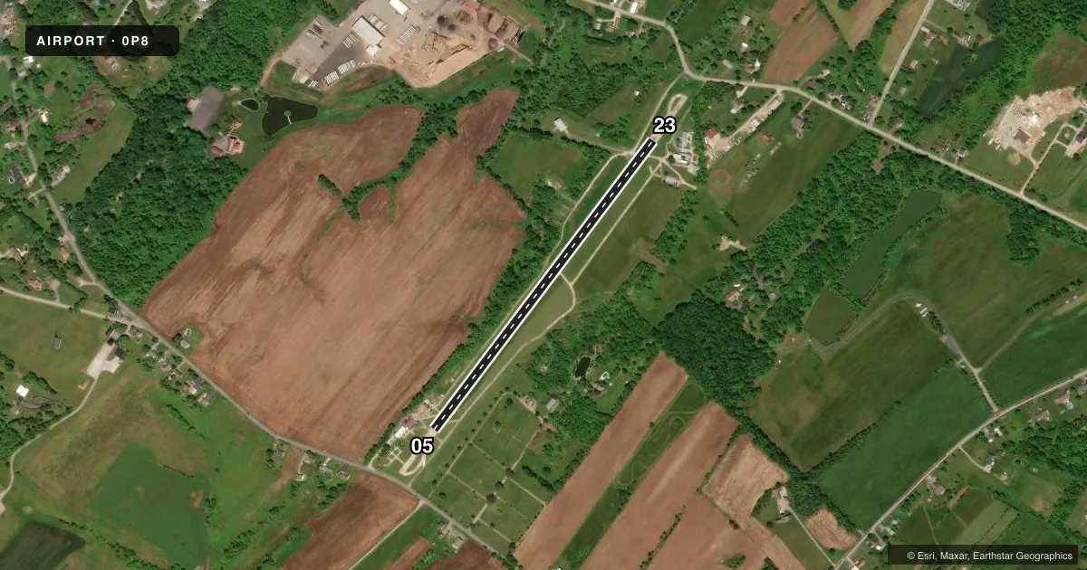
Runways & pattern
Full pagePattern entry · RWY 05
LEFT TRAFFICRunway end performance
| End | TORA | TODA | ASDA | LDA | VGSI | Approach lights | Obstruction |
|---|---|---|---|---|---|---|---|
| 23 | — | — | — | — | — | — | 13', trees, 211' from thr, 56' R of cntrln, slope 0 |
Declared distances in feet. TORA = takeoff run available, TODA = takeoff distance, ASDA = accelerate-stop, LDA = landing distance.
Airport sketch
Runways drawn to scale from FAA survey coordinates, rendered over satellite imagery. Not for navigation.
Approaches & charts
Services on the field
Fuel grades, oxygen, maintenance, ramp storage and lighting — as declared to the FAA by the airport operator.
Fuel & services
- Fuel
- Not available
- Airframe repair
- Not available
- Power plant repair
- Not available
Ramp & ground
- Transient storage
- Tie-down
- Buoy
- Landing fee
- No fee published
- Lighting schedule
- SEE RMK
- Wind indicator
- Yes
- Segmented circle
- No
Fuel & FBOs
Cheapest 100LL and Jet A on the field and nearby. Always confirm with the FBO before taxi.
Airport notes
Surface conditions, obstructions, local procedures, lighting outages and other notes published with each FAA cycle.
General notes
- TURF AREA PARALLEL TO RWY 5/23, FOR TAXI ONLY.
- FOR CD CTC HARRISBURG APCH AT 800-932-0712.
- DEER INVOF ARPT.
- RWY CLSD DLY SS-SR.
Lighting notes
- FOR LIRL RY 05/23 KEY 122.9 5 TIMES.
Approach & departure obstructions
- 23RWY 23: 6 FT TREES, 106 FT FM RWY END; 47 FT RIGHT OF CNTRLN.
- 05CTLNG OBSTN EXCEEDS A 45 DEG SLP.
Other notes
- 05/23LARGE PATCHES OF CONC ON EDGES OF RWY WITH SFC CRACKING AND VEGETATION GROWTH.
VFR map & nearby airports
VFR sectional. Tap any ICAO chip to open that airport.
Key facts · 0P8
Answer card- ICAO
- 0P8
- Name
- LAZY B RANCH
- Location
- DOVER, PENNSYLVANIA
- Elevation
- 476 ft MSL
- Traffic pattern altitude
- 1,476 ft MSL (1,000 AGL)
- Control tower
- Non-towered (use CTAF)
- Total runways
- 1
- Longest runway
- 05/23 · 2,400 ft
- Published ILS approaches
- 0
- Published frequencies
- 1
- Magnetic variation
- 10°
- Current flight rules
- VFR
- Current wind
- 000° at 0 kt
- Favored runway now
- –
Lazy B Ranch (0P8) sits in Dover, Pennsylvania at 476 ft MSL. It has one runway. Runway 05/23 is 2,400 ft long with asphalt and concrete pavement. The airport is not towered. CTAF is 122.9. No ILS approaches are published here.
The pattern altitude is not published. Use the standard 1,000 ft AGL unless the current Chart Supplement says otherwise. That puts the traffic pattern at about 1,476 ft MSL based on the field elevation. Verify the published pattern before you go. The field is close to Harrisburg Approach for clearance delivery. Published remarks also call out deer in the vicinity. Keep a sharp scan on taxi, takeoff and landing.
There is a turf area parallel to runway 05/23 for taxi only. The runway edges have large patches of concrete with cracking and vegetation growth. Low-intensity runway lighting is available on 05/23. To activate it, key 122.9 five times. No on-field FBOs are listed, so plan to confirm services directly with the airport operator before arrival.