METAR & TAF 2N5
2N5 does not publish a METAR.
Showing the nearest reporting station: KTHV (YORK) · 9.3 NM away. Conditions at 2N5 may differ.
METAR · KTHV
Observed 15:53Z
KTHV 271553Z AUTO 32007KT 10SM CLR 28/17 A2987 RMK AO2 SLP112 T02830172
- Wind
- 320° @ 7 kt
- Visibility
- 10 SM
- Temp / Dew
- 28°C / 17°C
- Altimeter
- 29.87 inHg
- Clouds
- CLR
- Density alt
- 2,380 ft
- Ceiling
- Unlimited
- Rules
- VFR
Airport info & contacts
Manager on record, flight service, ARTCC, attendance schedule and pattern altitude — published by the FAA and refreshed every 28 days.
Location
- From city
- 2 NM W
- VFR sectional
- NEW YORK
- ARTCC
- ZNY · NEW YORK
- NOTAM facility
- IPT (NOTAM-D)
Airport manager
- Name
- THOMAS E KAMPEL
- Phone
- 717-432-9688
- Address
- 8930 CARLISLE RD, WELLSVILLE PA 17365
Flight service · Hours
- FSS IPT
- WILLIAMSPORT1-800-WX-BRIEF
- Attendance
- APR-NOV · MON-FRI · 0800-1700
- APR-NOV · SAT-SUN · Unattended
Frequencies
Tap any row to copy the frequency to your clipboard.
Runways & pattern
Full pagePattern entry · RWY 05
LEFT TRAFFICRunway end performance
| End | TORA | TODA | ASDA | LDA | VGSI | Approach lights | Obstruction |
|---|---|---|---|---|---|---|---|
| 05 | — | — | — | — | — | — | 70', stack, 1081' from thr, 151' R of cntrln, slope 15 |
| 23 | — | — | — | — | — | — | 83', trees, 939' from thr, 183' R of cntrln, slope 11 |
Declared distances in feet. TORA = takeoff run available, TODA = takeoff distance, ASDA = accelerate-stop, LDA = landing distance.
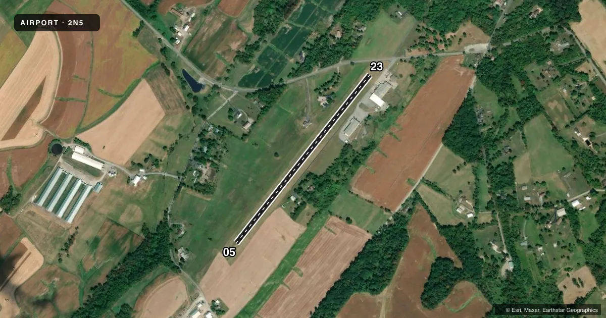
Airport sketch
Runways drawn to scale from FAA survey coordinates, rendered over satellite imagery. Not for navigation.
Approaches & charts
Services on the field
Fuel grades, oxygen, maintenance, ramp storage and lighting — as declared to the FAA by the airport operator.
Fuel & services
- Fuel
- 100LL
- Oxygen (bottled)
- Not available
- Oxygen (bulk)
- Not available
- Airframe repair
- Major
- Power plant repair
- Minor
Ramp & ground
- Transient storage
- Tie-down
- Landing fee
- No fee published
- Customs
- Not available
- Wind indicator
- Yes
- Segmented circle
- No
Fuel & FBOs
Cheapest 100LL and Jet A on the field and nearby. Always confirm with the FBO before taxi.
Airport notes
Surface conditions, obstructions, local procedures, lighting outages and other notes published with each FAA cycle.
General notes
- ARPT CLSD TO TRANSIENT ACFT NOV-APR.
- FUEL NOT AVLBL ON WKENDS.
- FOR CD CTC HARRISBURG APCH AT 800-932-0712.
Approach & departure obstructions
- 05DSPLCD THLD MKD WITH 3 YELLOW CONES EACH SIDE OF RWY.
- 23DSPLCD THLD MKD WITH 3 YELLOW CONES EACH SIDE OF RWY.
- 0505/23 MKD WITH YELLOW CONES.
- 05RWY 05 APCH SLP 20:1 TO DTHR.
- 23RWY 23 APCH SLOPE 20:1 TO DSPLCD THLD MARKED AT 686 FT.
Other notes
- VFR USE ONLY.
VFR map & nearby airports
VFR sectional. Tap any ICAO chip to open that airport.
Key facts · 2N5
Answer card- ICAO
- 2N5
- Name
- KAMPEL
- Location
- WELLSVILLE, PENNSYLVANIA
- Elevation
- 611 ft MSL
- Traffic pattern altitude
- 1,611 ft MSL (1,000 AGL)
- Control tower
- Non-towered (use CTAF)
- Total runways
- 1
- Longest runway
- 05/23 · 2,550 ft
- Published ILS approaches
- 0
- Published frequencies
- 1
- Magnetic variation
- 10°
- Current flight rules
- VFR
- Current wind
- 320° at 7 kt
- Favored runway now
- RWY 05
Kampel (2N5) sits near Wellsville, Pennsylvania. The field elevation is 611 ft MSL. It has one runway. Runway 05/23 is a 2,550 ft turf strip. There is no control tower. CTAF is 122.9. No ILS approaches are published here.
The published pattern altitude is not listed. Use the standard 1,000 ft AGL pattern unless the current Chart Supplement says otherwise. Kampel Enterprises is on the field. It carries 100LL. Fuel is not available on weekends. The airport is closed to transient aircraft from November through April, so call ahead before planning a stop.
This is a VFR-only airport. That matters here. Runway 05 and Runway 23 both have published 20:1 approach slopes to displaced thresholds marked with yellow cones. Runway 23 has a displaced threshold marked at 686 ft. If you are new to the field, brief the turf surface. Brief the displaced threshold markings. Brief the seasonal closure before you go. For clearance delivery, Harrisburg Approach is the published contact.