METAR & TAF KMDT
Current METAR
Observed 03:56Z
KMDT 270356Z 00000KT 10SM OVC100 24/20 A2984 RMK AO2 SLP102 T02390200 $
- Wind
- 000° @ 0 kt
- Visibility
- 10 SM
- Temp / Dew
- 24°C / 20°C
- Altimeter
- 29.84 inHg
- Clouds
- OVC
- Density alt
- 1,564 ft
- Ceiling
- 10,000 ft AGL
- Rules
- VFR
Airport info & contacts
Manager on record, flight service, ARTCC, attendance schedule and pattern altitude — published by the FAA and refreshed every 28 days.
Location
- From city
- 8 NM SE
- VFR sectional
- NEW YORK
- ARTCC
- ZNY · NEW YORK
- NOTAM facility
- MDT (NOTAM-D)
Airport manager
- Name
- TIM EDWARDS
- Phone
- 717-948-3900
- Address
- ONE TERMINAL DRIVE, MIDDLETOWN PA 17057
Flight service · Hours
- FSS IPT
- WILLIAMSPORT1-800-WX-BRIEF
- Attendance
- ALL
Frequencies
Tap any row to copy the frequency to your clipboard.
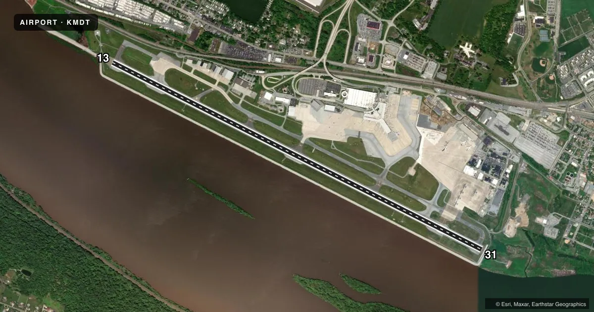
Runways & pattern
Full pagePattern entry · RWY 13
LEFT TRAFFICRunway end performance
| End | TORA | TODA | ASDA | LDA | VGSI | Approach lights | Obstruction |
|---|---|---|---|---|---|---|---|
| 13 | 10,001' | 10,001' | 9,063' | 8,070' | PAPI 4-box left(3°) | ALSF2 | 60', pole, 1780' from thr, 719' R of cntrln, slope 26 |
| 31 | 10,001' | 10,001' | 9,122' | 8,129' | PAPI 4-box left(3°) | — | 79', trees, 2485' from thr, 712' R of cntrln, slope 29 |
Declared distances in feet. TORA = takeoff run available, TODA = takeoff distance, ASDA = accelerate-stop, LDA = landing distance.
Airport sketch
Runways drawn to scale from FAA survey coordinates, rendered over satellite imagery. Not for navigation.
Approaches & charts
ILS · 2
Services on the field
Fuel grades, oxygen, maintenance, ramp storage and lighting — as declared to the FAA by the airport operator.
Fuel & services
- Fuel
- 100LLA
- Oxygen (bottled)
- Low pressure
- Oxygen (bulk)
- HIGH/LOW
- Airframe repair
- Major
- Power plant repair
- Major
- Other services
- AVNCS,CHTR,INSTR,RNTL
Ramp & ground
- Transient storage
- Tie-down
- Hangar
- Landing fee
- Yes
- Customs
- Not available
- Beacon schedule
- SS-SR
- Beacon
- White / Green (civil land)(WG)
- Wind indicator
- Lighted
- Segmented circle
- No
Fuel & FBOs
Cheapest 100LL and Jet A on the field and nearby. Always confirm with the FBO before taxi.
Airport notes
Surface conditions, obstructions, local procedures, lighting outages and other notes published with each FAA cycle.
General notes
- CARGO RAMP CLSD TO TSNT ACFT WO PRIOR PERMISSION; CALL AMGR 717-948-3919.
- BIRD FLOCKS ON & INVOF ARPT.
- NO TOUCH & GO LDGS 2300-0600 LCL.
- REMARKS-ANG: ACFT NOT SUPPORTING ANG AND ALL FIGHTER ACFT MUST CTC FBO C 717-944-4666 FOR PRK AND FUEL. NSTD MRK ON C130J PRK APRON SPOT 5; WHITE PAINTED LINES DENOTING LAIRCM LASER TESTING AREA.
- ACFT DESTINED FOR AVFLIGHT HARRISBURG SO INDICATE IN RMK SEC OF DD175 AND ATTEMPT TO CTC WITH ETA ON 122.95, 15 MIN PRIOR TO LND.
- BIRD WATCH COND PHASE 1 (DEC-FEB & MAY-JUL) INDICATED LGT BIRD ACT. PHASE 2 (AUG-NOV & MAR-APR) INDICATES HVY BIRD ACT NML ASSOCIATED WITH MIGRATORY SEASON.
- CARGO APRON PARKING SPOT 9 CLOSED TO ACFT WITH A WINGSPAN OF MORE THAN 52 FT.
- COLD TEMPERATURE AIRPORT. ALTITUDE CORRECTION REQUIRED AT OR BELOW -16C.
- USE CTN: DUE TO PROXIMITY & RWY ALMNT, AIRCREWS HAVE MISTAKEN CXY RWY 12/30 FOR MDT RWY 13/31 WHICH IS 4 NM E.
Runway surface & condition
- 13/31PCR VALUE: 800/F/C/X/T
Approach & departure obstructions
- 13RWY 13: PIR AND MIL ASSAULT LDG ZONE MKGS.
- 31RWY 31: PIR AND MIL ASSAULT LDG ZONE MKGS.
- 13APCH RATIO 47:1 TO DTHR.
- 31RWY 31 APCH SLP 36:1 TO DTHR.
Other notes
- TPA 1300 FT MSL (990 FT AGL) PROPS; 1800 FT MSL (1490 FT AGL) JETS.
VFR map & nearby airports
VFR sectional. Tap any ICAO chip to open that airport.
Key facts · KMDT
Answer card- ICAO
- KMDT
- Name
- HARRISBURG INTL
- Location
- HARRISBURG, PENNSYLVANIA
- Elevation
- 310 ft MSL
- Traffic pattern altitude
- 1,310 ft MSL (1,000 AGL)
- Control tower
- Towered · 24
- Total runways
- 1
- Longest runway
- 13/31 · 10,001 ft
- Published ILS approaches
- 2
- Published frequencies
- 19
- Magnetic variation
- 11°
- Current flight rules
- VFR
- Current wind
- 000° at 0 kt
- Favored runway now
- –
Harrisburg Intl sits in Harrisburg, Pennsylvania. The field elevation is 310 ft MSL. It has one runway. Runway 13/31 is 10,001 ft long with asphalt pavement. The tower is open 24 hours. Two ILS approaches are published, one for each runway end.
Pattern altitude is published at 1,300 ft MSL for propeller aircraft. That is 990 ft AGL. Jet pattern altitude is 1,800 ft MSL. That is 1,490 ft AGL. Avflight Harrisburg is the on-field FBO. It carries 100LL, Jet A and Jet A with Prist. Call them at (717) 944-4666 for current service details.
This is a Class C field. Use the current chart and listen carefully on arrival. The airport remarks call out runway and taxiway confusion risk. Taxiway 12/30 has been mistaken for runway 13/31, which sits 4 NM east. Runway 13 and runway 31 both have precision instrument markings. The field is also a cold temperature airport. Altitude correction is required at or below minus 16 degrees Celsius. There is a no touch-and-go window from 2300 to 0600 local time. Bird activity also rises in the migratory seasons, so plan your scan on approach and departure.